B
Brick Tamland
Guest
Can we get a late winter storm in the southeast? Or maybe an early start to severe season? Or will we just more and more rain? Stay tuned for the March edition of As The Weather Turns!
NC/SC has CADI'm sure we'll have non-stop Cad reports all month long. Your cad, his cad, your momma's cad, grandma's cad in 1922. About the only thing I see on this board these days is CAD. Long live the CAD.
My great grandmas CAD was the best! Severe will be almost non-existent in the CAD areas for all of March/April, but not cold enough for snow/ice! Just look what it did to the line of storms a few days ago!I'm sure we'll have non-stop Cad reports all month long. Your cad, his cad, your momma's cad, grandma's cad in 1922. About the only thing I see on this board these days is CAD. Long live the CAD.
I'm sure we'll have non-stop Cad reports all month long. Your cad, his cad, your momma's cad, grandma's cad in 1922. About the only thing I see on this board these days is CAD. Long live the CAD.

Lol how does a map like that even happenEven your grandma's snowstorm in 1922 was a Roxboro crush job, arguably the most epic one ever.
View attachment 15935
Lol how does a map like that even happen
Even your grandma's snowstorm in 1922 was a Roxboro crush job, arguably the most epic one ever.
View attachment 15935
Folks will love the 18Z GEFS as it is one of the coldest runs yet for the country as a whole (and for the Midwest especially) due to several Arctic highs and it also suggests Miller A action along the SE fringe of the cold from one or more lows moving from the GOM to off the SE coast. Verbatim, it shows a good sized threat for SN for a good portion of TN/NC but we know how this song and dance has gone. Hopefully, there won't be a NW trend/stronger than modeled SER to cause any storm to track well inland and thus mean mainly rain for NC/TN but we know quite well that would be quite possible. This doesn't mean areas further south couldn't also cash in because this is a nice setup in general from this far out, but obviously it would be more difficult as that isn't showing on the mean verbatim.
Remember that the 11-15 day GEFS has had a strong cold bias of some 7-8 degrees in much of the SE for many weeks averaged out. Take away 7-8 degrees and you'd have slightly warmer than normal SE. So hopefully things change this time.

Wait til folks see the 0Z GEFS for 2/28+ OMG

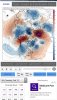
-AO, -NAO, -EPO?, +PNA?Folks will love the 00z gfs (had to do it @GaWx ?) Big displacement of the PV due to that ridging around Greenland, the JB theory ? this is it chief View attachment 15948
I’ll buy the -EPO with a weak +PNA and maybe a touch of ridging at the pole but NOT a -NAO..miss me w that bs

Folks, the 0Z GEFS has some sections of the Midwest/N Plains a mind boggling 30 colder than normal for Mar 1-5!!! See pic below. I'm not talking just one day on an operational run but a 5 day period on an ensemble!!! Do you realize how incredible that that is even showing up and how incredible that would be? To sort of quote John Sterling, that would be the wackiest, wildest, most incredible wx pattern in history. This is not normal. If this happens, fasten your seatbelts, folks. Something crazy seems to want to occur but will it actually happen?? And by the way, there is practically no cold bias of the GEFS up there.
So, how cold would 30 below normal be at Des Moines? Oh, only 19 colder than normal for the heart of January!! I can't even wrap my head around this. I'm going to search March for past years in Des Moines and see if I can see anything even close to a 5 day period averaging 30 colder than normal:
View attachment 15950

Yes, sort of. In your image, the trough east of HI has moved where he thought it would. The EPO ridge and NAO ridge join, as he thought. The PV moves south, and the PNA goes up. Ok, that part is in line with his thinking. The difference is the strength of the anomalies in the NAO/EPO spaces. They need to be reversed (strongest anoms near Greenland). That would press the core of the cold south into the TN Valley, suppressing the storm track and setting the SE up for a 2-3 week period of winter weather opportunities. That last part seems unlikely to happen, as we don't seem to be able to get any lasting cooperation in with the NAO. I'm still optimistic for an event or two before the winter is out. At least getting some legit front-end snow/ice seems likely to me.Isn’t this what JB said would happen lol @Rain Cold ?
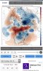
This would completely crash the PV lobe into the US/major displacement, this is a Miller A/southern Slider pattern right here, I don’t think the gefs is to cold with this kind of look this time, question is will it hold View attachment 15939
So what makes a 336 hour storm so special? Not going to happen. Willing to even put money on that it won't.Well, we had our only storm a lot earlier than usual. Who's to say we can't have another one a lot later than usual? And that does look maaahvelous.
So what makes a 336 hour storm so special? Not going to happen. Willing to even put money on that it won't.


12z gefs is still decent, still we need quite a bit more ridging around Greenland for a stronger PV lobe displacement, PNA has looked more nuetral/weaker + with these past runs, need to stop that trend, this is a pattern we can still work with but it could be much better than this, this looks pretty similar to the EPS @Rain Cold posted above View attachment 15996