B
Brick Tamland
Guest
GFS, UK, and FV3 all look awesome for most of NC, especially Wake westward.
A very wise route for them to be taking. Many possibilities still on the table.FFC:
LONG TERM /Thursday Night through Tuesday/...
The main concern for the long term period continues to be the
potential for a winter mix of precipitation across portions
of the forecast area this coming weekend into Tuesday morning.
The GFS and European are similar with developing low pressure
along the Gulf Coast and moving it across S GA on Sunday and then
into the Atlantic thereafter with the GFS being a little faster.
Deep moisture is forecast to move over the area Friday night and
Saturday with a rather strong surface ridge of high pressure
developing down the eastern Appalachians providing a strong
overrunning flow. The question will be is how cold the airmass
will be through Sunday over the far ne, especially the mountains.
For the most part, a cold rain can be expected. However a period
of a winter mix is possible of mainly sleet, possibly snow, and
this will depend greatly on how cold the airmass is over the NE
counties. Confidence is low for significant accumulations of sleet
but you can NOT rule it out and it will be a watch and monitor of
future model runs to see how this system might develop.
The associated upper system moves to the area Sunday night into
Monday night giving potential for a Rain/Snow shower mix.
At this time, any precipitation amounts with the upper system
are expected to be light.
Never underestimate the wedge in NE GA. I don't see the city of ATL getting much of anything but as always Gwinnett, Forsyth, etc tend to hold on to the cold air longer.
Close to 20" in Chatham, ill take it!!!FV3 Kuchera looks great, too.
I agtee!I think ATL and even just south/west also have a good shot at significant ZR. The GFS looks too warm to me.
I think most in Raleigh would take that in a heartbeat. We are going to rain some.If I was at Raleigh, I would expect 3/4 of the storm to be ip and 1/4 snow
These maps tend to not be as accurate as the bufkit extracted data. I can post that info when it updates.
Don't do it, it's not nearly as purdy.... LolThese maps tend to not be as accurate as the bufkit extracted data. I can post that info when it updates.
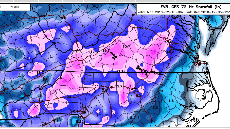
I like your optimism Brick, but it is important to remember that the models assume all snow will stick and with marginal temps like we will likely be seeing, some of the snow may melt upon contact. Also, most of the models indicate a warm nose will result in precipitation changing over to rain for a while from Sunday afternoon into Monday.Sure is nice to see the totals today actually be consistent or increase on most of the model runs instead of the other way around. Looks like most have anywhere from 6 to 12 inches across Wake.
Packfan98 shared this earlier but here it is again..... have funAny chance of getting a bufkit on gsp
I like your optimism Brick, but it is important to remember that the models assume all snow will stick and with marginal temps like we will likely be seeing, some of the snow may melt upon contact. Also, most of the models indicate a warm nose will result in precipitation changing over to rain for a while from Sunday afternoon into Monday.
I expect Wake Co accumulations to be around 1-2" of snow/sleet mix on Sunday morning, followed by rain melting most of the snow from the initial front end thump. An additional dusting to an inch, perhaps a bit more, snow is possible on Monday night from the back side of the system. Could be wrong for sure but that is my current thinking.

And you know this how? Give us your reasoning synoptically
There's your reasoning right there! Interesting info about latent heat release actually contributing to the warm nose, most of us know about it's effects at the surface (zr self limiting, etc) but that part was new to me (or at least I've missed it somewhere before). Great stuffIt's a cascading failure that happens with global models and CAD east of the Appalachians. I've seen this time and time again as a long time NC resident. NAM will likely have a better thermo profile than the global models, but a lot of this happens in real time and therefore is very hard to forecast.
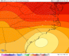
Prequil: GFS already shows geostrophic adjustment east of the mountains as the parent high slides to our north before the arrival of the precip early Sunday morning...so a CAD will already be in place (along with cold DRY air). The dryness of the air will definitely matter, but we won't know this until we see OBS most likely. So great, the model has no problem with this. Check out the image valid Sunday AM for MSLP, you can see the CAD there.
Now to the cascading failure part
1. Precip begins falling into the dry airmass (CAD), resulting in evaporation cooling. That very crudely represented in hydrostatic nwp, so it ends up not being modeled correctly and is often underestimated. To make matters worse, the GFS does not have parameterizations for phase changes, so all that refreezing into sleet that's going to be happening in and under the warm nose is not accounted for. The result? Lot's of latent heat release on top of the CAD resulting in a stronger warm nose than what's represented in the nwp. So at this point we now have a stronger, deeper, CAD and a warmer warm nose than forecast.
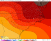
2. Here we go with feedback now. Not only are we getting QG forcing for ascent from the DPVA, but we have a very significant contribution from the WAA (synonymous to isentropic upglide), which especially drives precip on the front end. As a result of the stronger than forecast CAD, isentropic upglide is enhanced (more WAA than forecast), which results in a beefier warm nose than forecast. Already the gfs forecast some extreme WAA (see attached image) during the precip, and this is likely underdone.
So now our warm nose is very strong, and the CAD is extremely entrenched, which is considered high impact...so now it's going to take a lot more than WAA and a low to our east to erode the CAD.
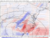
3. NWP is notorious for eroding a CAD to quickly. Climo tells us it's going to stick around, so the fact that the GFS completely erodes the CAD by 18-21z Sunday is complete BS (see mslp image attached). There are certain synoptic patterns in which CAD erodes, and this is not one of them. So almost certainty the low will track further east than forecast (along the coastal front, edge of the CAD) and not do much to erode it.
All of this results in an almost impossible precipitation forecast, but it will do things like throw sleet all the way back to the Triad, even though you don't even see a hint about it in the global nwp. Could even result in there being more sleet further southeast than forecast before a complete changeover to rain. NAM is alot better with thermo profiles, but a lot of this will be now-casting during the event.
Who knows about totals, but imo, Raleigh gets some snow to start, then quickly to sleet and eventually rain, while the Triad will be extremely lucky to stay snow the whole time and not mix with sleet at some points. I don't buy these foot+ totals except for the extreme NW piedmont & mountains.
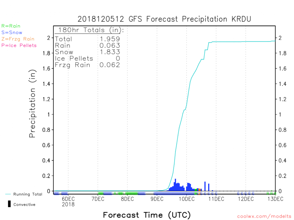
Considering model biases, our history with warm noses, how much QPF this has and potential for compaction by sleet, something in the ballpark of 6-12” seems conservatively reasonable for the Triad this far out, the front end thump of snow being depicted certainly brings Feb 2014 flashbacksFor KGSO it is 20.3" Snow, .08 Sleet and 0.00 ZR
Nice to see you here on the forum man!It's a cascading failure that happens with global models and CAD east of the Appalachians. I've seen this time and time again as a long time NC resident. NAM will likely have a better thermo profile than the global models, but a lot of this happens in real time and therefore is very hard to forecast.
Prequil: GFS already shows geostrophic adjustment east of the mountains as the parent high slides to our north before the arrival of the precip early Sunday morning...so a CAD will already be in place (along with cold DRY air). The dryness of the air will definitely matter, but we won't know this until we see OBS most likely. So great, the model has no problem with this. Check out the image valid Sunday AM for MSLP, you can see the CAD there.
Now to the cascading failure part
1. Precip begins falling into the dry airmass (CAD), resulting in evaporation cooling. That very crudely represented in hydrostatic nwp, so it ends up not being modeled correctly and is often underestimated. To make matters worse, the GFS does not have parameterizations for phase changes, so all that refreezing into sleet that's going to be happening in and under the warm nose is not accounted for. The result? Lot's of latent heat release on top of the CAD resulting in a stronger warm nose than what's represented in the nwp. So at this point we now have a stronger, deeper, CAD and a warmer warm nose than forecast.
2. Here we go with feedback now. Not only are we getting QG forcing for ascent from the DPVA, but we have a very significant contribution from the WAA (synonymous to isentropic upglide), which especially drives precip on the front end. As a result of the stronger than forecast CAD, isentropic upglide is enhanced (more WAA than forecast), which results in a beefier warm nose than forecast. Already the gfs forecast some extreme WAA (see attached image) during the precip, and this is likely underdone.
So now our warm nose is very strong, and the CAD is extremely entrenched, which is considered high impact...so now it's going to take a lot more than WAA and a low to our east to erode the CAD.
3. NWP is notorious for eroding a CAD to quickly. Climo tells us it's going to stick around, so the fact that the GFS completely erodes the CAD by 18-21z Sunday is complete BS (see mslp image attached). There are certain synoptic patterns in which CAD erodes, and this is not one of them. So almost certainty the low will track further east than forecast (along the coastal front, edge of the CAD) and not do much to erode it.
All of this results in an almost impossible precipitation forecast, but it will do things like throw sleet all the way back to the Triad, even though you don't even see a hint about it in the global nwp. Could even result in there being more sleet further southeast than forecast before a complete changeover to rain. NAM is alot better with thermo profiles, but a lot of this will be now-casting during the event.
Who knows about totals, but imo, Raleigh gets some snow to start, then quickly to sleet and eventually rain, while the Triad will be extremely lucky to stay snow the whole time and not mix with sleet at some points. I don't buy these foot+ totals except for the extreme NW piedmont & mountains.
Thanks, I need to participate in this more often. A lot of my meteorological connects in the Triangle have moved away!Nice to see you here on the forum man!
 Hour 78 euro
 Unmmmm..... Nice!
 Hour 84
Heck yeah looks like that's setting up to be a decent front end thump