That’s the track I need right there!! When’s the soonest they would maybe send in a plane??
-
Hello, please take a minute to check out our awesome content, contributed by the wonderful members of our community. We hope you'll add your own thoughts and opinions by making a free account!
You are using an out of date browser. It may not display this or other websites correctly.
You should upgrade or use an alternative browser.
You should upgrade or use an alternative browser.
Tropical Major Hurricane Michael
- Thread starter ForsythSnow
- Start date
Brent
Member
That’s the track I need right there!! When’s the soonest they would maybe send in a plane??
Looks like Sunday afternoon
I. ATLANTIC REQUIREMENTS
1. NEGATIVE RECONNAISSANCE REQUIREMENTS.
2. OUTLOOK FOR SUCCEEDING DAY: POSSIBLE LOW-LEVEL
INVEST IN THE WESTERN CARIBBEAN NEAR
17.5N 86.5W FOR 07/1800Z.
A broad area of low pressure centered near the northeastern coast
of Honduras is drifting northwestward and producing disorganized
shower and thunderstorm activity from Central America
east-northeastward across the Western Caribbean to Hispaniola.
Although strong winds aloft persist just to the north of the
system, the upper-level environment is expected to be conducive
enough to allow slow development. A tropical depression could
form by late this weekend or early next week over the northwestern
Caribbean Sea or Gulf of Mexico while the system moves northwestward
to northward. Regardless of tropical cyclone formation, this
disturbance will continue to bring torrential rains primarily to
portions of Central America and the Yucatan peninsula during the
next few days.
* Formation chance through 48 hours...medium...40 percent.
* Formation chance through 5 days...high...70 percent.
WXinCanton
Member
Navgem FWIW

Storm5
Member
Euro has a weak system into the panhandle on Thursday
Sent from my iPhone using Tapatalk
Sent from my iPhone using Tapatalk
ForsythSnow
Moderator
Officially 91L now.
Euro has a weak system into the panhandle on Thursday
The 12Z Euro is actually stronger than the 0Z during most of the track in the Gulf.
GeorgiaGirl
Member
Euro free maps looks like a TS to me. I'd sign for a weak TS/TD that tracks into Georgia. Hopefully it doesn't turn into more for the sake of people that live near the coast.
WXinCanton
Member
Never gets it much further north than Columbus. Meanders thru south GA then back out into the Atlantic
WXinCanton
Member
Yeah, I would just like some rain.Euro free maps looks like a TS to me. I'd sign for a weak TS/TD that tracks into Georgia. Hopefully it doesn't turn into more for the sake of people that live near the coast.
Euro brings some strong winds inland, in fact stronger inland than along the coast....

18z Gfs shows a Cat 1 Or even Cat 2 Wow. Hopefully this storm doesn’t stall close offshore.
The TWC hurricane guy says he expects the NHC to up the percentages to go up from 70%, at the 8pm update!
I know it’s a model run, but the Euro grossly overestimated the wind gusts in Florence on the high side. They were showing my area with some 60+ mph gusts, and highest we got was like 29. Just an observation, as we get closer to landfallEuro brings some strong winds inland, in fact stronger inland than along the coast....
Last edited:
Henry2326
Member
18z Gfs shows a Cat 1 Or even Cat 2 Wow. Hopefully this storm doesn’t stall close offshore.
958 pressure on Wednesday. Sooner than 12z version by about 8 hours.

Henry2326
Member
80%
Tropical Weather Outlook
NWS National Hurricane Center Miami FL
800 PM EDT Fri Oct 5 2018
For the North Atlantic...Caribbean Sea and the Gulf of Mexico:
The National Hurricane Center is issuing advisories on Tropical
Storm Leslie, located over the central Atlantic Ocean.
1. Surface observations and satellite data indicate that a broad area
of low pressure is centered near the coast of Honduras. This system
is producing a large area of disturbed weather extending from
Central America east-northeastward across the Western Caribbean to
Hispaniola. Environmental conditions are expected to become more
favorable for development, and a tropical depression will likely
form over the northwestern Caribbean Sea or the southern Gulf of
Mexico by late this weekend or early next week while the system
moves slowly toward the northwest and north. Regardless of tropical
cyclone formation, this disturbance will continue to bring
torrential rains primarily to portions of Central America, and these
rains should then spread over western Cuba and the Yucatan peninsula
during the next few days.
* Formation chance through 48 hours...medium...50 percent.
* Formation chance through 5 days...high...80 percent.
Forecaster Avila
Looks we have another system to track.
pcbjr
Member
Aw damm poopLooks we have another system to track.
GeorgiaGirl
Member
Is there even a historical comp for the track that I'm seeing? Seems weird to me. But I might be missing an analog that was like that track.
Major Shift South On 0z Gfs tracks storm through Lowcountry of SC.
accu35
Member
0z icon west from 18z. CMC still landfall in La, 12z EURO pensacola area, FV3 still loading and navy not out yet. As of now, gfs is the furthest east
Brent
Member
dang ASCAT is almost closed...

Honestly this system is less than a week from making landfall and yet no one is talking about it on here as much.
Brent
Member
Recent satellite-derived wind data indicate that an area of low
pressure is centered about 80 miles north of the coast of Honduras,
however, the system is somewhat elongated and does not yet have a
closed circulation. Heavier showers and thunderstorms have been
developing near and to the east of the low's center during the past
several hours, and extensive cloudiness and showers extend elsewhere
across the western Caribbean Sea eastward over the Greater Antilles.
Environmental conditions are expected to become gradually more
conducive for further development, and a tropical depression is
expected to form over the northwestern Caribbean Sea or the southern
Gulf of Mexico over the weekend or early next week while the system
moves slowly north-northwestward at about 5 mph. Interests in the
Yucatan peninsula and western Cuba should monitor the progress of
this system during the next several days. Regardless of tropical
cyclone formation, this disturbance will continue to bring
torrential rains to portions of Central America, the Yucatan
peninsula, and western Cuba into next week.
* Formation chance through 48 hours...high...70 percent.
* Formation chance through 5 days...high...90 percent.
$$
Blue_Ridge_Escarpment
Member
Euro at 120 just south of MS/AL line.
 Euro going with a very weak storm, around Mobile AL landfall!
 Then very, very slow movement !!!! Moves about 150/200 miles in 3 days!
 Thursday....
 Sunday...!!!!!
0z eps staring to tighten up some.

Kylo
Member
6z GFS would not be good for eastern Carolinas again.

Yellow Snow
Member
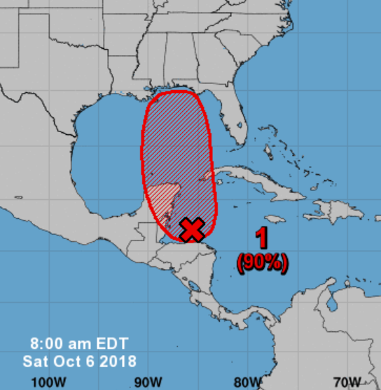
8:00am tropical outlook from the NHC
Henry2326
Member
8 am. 80/90%
Tropical Weather Outlook
NWS National Hurricane Center Miami FL
800 AM EDT Sat Oct 6 2018
For the North Atlantic...Caribbean Sea and the Gulf of Mexico:
The National Hurricane Center is issuing advisories on Tropical
Storm Leslie, located over the central Atlantic Ocean.
1. Satellite imagery, surface observations, and radar data from Belize
indicate that an area of low pressure is centered just north of the
Bay Islands of Honduras. The associated showers and thunderstorms
show signs of organization, however, the system does not yet have a
well-defined circulation. Environmental conditions are expected to
become gradually more conducive for further development, and a
tropical depression or tropical storm is expected to form over the
northwestern Caribbean Sea or the southern Gulf of Mexico on Sunday
or Monday while the system moves slowly northward. Interests in the
Yucatan peninsula, western Cuba, and the northern coast of the Gulf
of Mexico should monitor the progress of this system during the next
several days. Regardless of tropical cyclone formation, this
disturbance will continue to bring torrential rains to portions of
Central America, the Yucatan peninsula, and western Cuba into next
week.
* Formation chance through 48 hours...high...80 percent.
* Formation chance through 5 days...high...90 percent.
Slow moving system with trough interaction spells trouble
Sent from my SM-G920V using Tapatalk
Henry2326
Member
Yup...all with trough interaction with similar paths. See charts on global model run thread.Slow moving system with trough interaction spells trouble
Sent from my SM-G920V using Tapatalk
Eloise 9/23/75 955 MB 125 mph
Opal 10/6/95 . 916 mb 150 mph
Agnes 6/23/72. 977 MB. 85 mph
Florence 9/26/53. 968 MB 115 mph. Landfall 80 mph
Flossy 9/30/56 . 974 MB 90 mph...2 landfall...mouth of MS river and Ft. Walton/Destin, FL
Appears to be somewhat similar to Opal in 1995, in regards to track and time of year. Opal was stronger storm and this doesn't appear to be as strong. Opal also went further north. I guess it comes down to the stubborn SER. Some forecasts have a trough pushing it out with a front later this upcoming week but we have seen how that goes. If it does get caught up by that front, it seems to me that it will be pulled further NNE. If not, then it could be much slower. Just my uneducated observations though ....
Henry2326
Member
Courtesy of Mike's Weather page. EURO/GFS

pcbjr
Member
FS,
As much as the Lake may need a drink, I'm really hoping that you don't have to endure this ...

Phil
As much as the Lake may need a drink, I'm really hoping that you don't have to endure this ...
Phil
accu35
Member

NoSnowATL
Member
Bring it, ATL needs the rain at roof replacements make me money.GFS west
12z Models Update
Gfs: West
CMC: East. track through LA/MS
Icon: East
Gfs: West
CMC: East. track through LA/MS
Icon: East