Webberweather53
Meteorologist
Low strength is vital as well. Weak won't pull in the cold air.Someone said the UK had the low tracking across the FL panhandle? If so, money
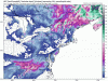
That won't do the trick. Too weak and likely too warm even at 850.Not much precip into NC or SC with this run though.
View attachment 4365 View attachment 4366 View attachment 4367 View attachment 4368
How did the 12z do compared to 0z? We need rain here in South Carolina. #drought
Worry about track first, precip 2nd, and temps 3rd! And Mid Atlantic people are probably about to cry!Not much precip into NC or SC with this run though.
View attachment 4365 View attachment 4366 View attachment 4367 View attachment 4368
12Z Euro is way South like the UKMET. Always hard to beat the Euro/UKMET combo. Will definitely be interesting to see how this one turns out.12z GFS and 12Z Can to go along with 12z Nam from Jon above.

Anyone Have the 12z euro maps? My subscription ran out yesterday but I may need to re up if things continue to trend better. I'm sitting at 39 degrees as of 1:50 pm. Also got some Fluries around midnight last night and woke up to a minor dusting that quickly melted after sunrise.


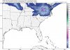
Move that about 50-100 miles North and I think it is reasonable, so basically S.Va northwardJust for entertainment:


.thumb.png.319951ad6dc5a85977b189f368372c9c.png")