Shaggy
Member
At least my local nws office is more bullish on storms today for me. They almost speak in certainties that this time its gonna happen. Will be needed to cool us down80/77 @ 7:45 lol
At least my local nws office is more bullish on storms today for me. They almost speak in certainties that this time its gonna happen. Will be needed to cool us down80/77 @ 7:45 lol
80/77 @ 7:45 lol
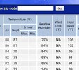
| Humidity | 94% |
| Wind Speed | Calm |
| Barometer | 29.97 in |
| Dewpoint | 79°F (26°C) |
| Visibility | 10.00 mi |
| Heat Index | 89°F (32°C) |
| Last update | 3 Jul 7:45 am EDT |
At least my local nws office is more bullish on storms today for me. They almost speak in certainties that this time its gonna happen. Will be needed to cool us down
? Yeah that's horrible.Yeah give me 101 with NW flow and low dews any day over this crap....heat index pushing 90 before 8am...
81°F
27°C
Humidity 94% Wind Speed Calm Barometer 29.97 in Dewpoint 79°F (26°C) Visibility 10.00 mi Heat Index 89°F (32°C) Last update 3 Jul 7:45 am EDT

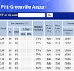
Pgv is now 88/81 with a HI of 106 at 1015amCedar Island heat index is 103 at 9am lol....probably gonna see some 115-120 values along the IBX today
View attachment 135660
Pgv is now 88/81 with a HI of 106 at 1015am
yeah a heat index of 113 at 11:15am is straight from pits of hell.IT feels like total satans armpit down here right now.
All you need is a nice fetch of wind off the Gulf of Mexico for a few days and high temps. You don't need a tropical system. We are just a stones throw away from the sub-tropics. Very typical of summer, if you ask me. Happens every year. We have a nice Bermuda high setting up, lots of cape, 30% chance of afternoon thunderstorms every day...very, very typical. What we don't want is a ridge to center itself right over MS and drive dry air into our region for days... Your dry air is out west and you want it to stay out there. Come September, we will get some lower dew points as the troughs start to penetrate deeper into the southeast US. Until then, enjoy your swamp ass weather!What's with these crazy high dews? It took a landfalling hurricane to get dews like these in the past.
Sent from my iPhone using Tapatalk
What's with these crazy high dews? It took a landfalling hurricane to get dews like these in the past.
Sent from my iPhone using Tapatalk
Mixing us out too much maybe?Hrrr is a big ouch for today

Nah we get several days like this every year....at least around here.
Mixing us out too much maybe?
Yep got .11 and knocked power out