Pattern June 29-July 2 Heat Wave

  • Hello, please take a minute to check out our awesome content, contributed by the wonderful members of our community. We hope you'll add your own thoughts and opinions by making a free account!
I mean, last winter overall still ended up above average temp-wise for Texas.

DFW averages 2" of snow per year, and it's perfectly normal for it to get brief cold snaps and intermittent snow/ice events. In total, DFW got about 1.8" of sleet last year, right in line with climo.

Feb '21 was indeed highly unusual, especially with respect to coverage/duration and the fact that ERCOT's capacity is under even more strain these days because of the explosive population growth, but even it wasn't entirely unprecedented (see 2011 and 1983).

As far as Summers, 2019-2021 were fairly pedestrian by Texas standards, if not a bit on the cool side. And don't forget, the hottest Summer of all was way back in 1980. With respect to this Summer, it's too early to judge how it will playout. Although with the Canadian wildfires having similar cooling effects in the atmosphere as the big Volcano eruption did in 1992 across the NE US and the burgeoning El Nino amplifying the STJ, any ridging and potential heatwaves going forward are looking a lot messier, especially for North Texas (see the way the pattern played out through mid-June for example).

But my overall point is there isn't enough hard statistical evidence to suggest the weather patterns are becoming any more wonky for us than usual, other than the frequency of tornado outbreaks having taken a huge nose dive (which is a good thing).

Yeah I mean we can sit here and talk about 2021 all day but I lived in Dallas from 2014-2021 and I had exactly one winter besides that with a real snowfall... It was rough. 5 winters in a row nothing more than a flake basically

Also the 90s were bad for snow too while the east coast had the blizzards so I think a lot of it is cycles

The summers have always been iffy outside of a few days here and there but still 1980 and 2011 haven't been topped. Just imagine if it was over 110 everyday like it was then...

Heck up here our all time high is still from 1936! Has yet to be topped
 
Last edited:
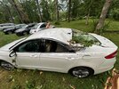
First 90 degree day of the year for about 2 hours and it stormed and dropped it right back down in the 80’s and with cloud covered. Good luck to everybody in the mid to upper 90’s. I’ll at least be at most 90-91 this early week which is a win if the rest of the SE is hovering around 100 during the summer.
 
I don't think I have ever seen a watch for only a 3 1/2 hour time period before.

SEVERE THUNDERSTORM WATCH OUTLINE UPDATE FOR WS 433
NWS STORM PREDICTION CENTER NORMAN OK
225 PM EDT SUN JUL 2 2023

SEVERE THUNDERSTORM WATCH 433 IS IN EFFECT UNTIL 600 PM EDT
FOR THE FOLLOWING LOCATIONS

NCC001-033-063-065-069-077-083-101-127-131-135-145-181-183-185-
195-022200-
/O.NEW.KWNS.SV.A.0433.230702T1825Z-230702T2200Z/

NC
. NORTH CAROLINA COUNTIES INCLUDED ARE

ALAMANCE CASWELL DURHAM
EDGECOMBE FRANKLIN GRANVILLE
HALIFAX JOHNSTON NASH
NORTHAMPTON ORANGE PERSON
VANCE WAKE WARREN
WILSON
 
  • Like
Reactions: weather bubba
Some storms to my north.

SEVERE THUNDERSTORM WARNING
NATIONAL WEATHER SERVICE RALEIGH NC
316 PM EDT SUN JUL 2 2023

THE NATIONAL WEATHER SERVICE IN RALEIGH HAS ISSUED A

* SEVERE THUNDERSTORM WARNING FOR...
NORTHERN VANCE COUNTY IN CENTRAL NORTH CAROLINA...
NORTHERN GRANVILLE COUNTY IN CENTRAL NORTH CAROLINA...

* UNTIL 345 PM EDT.

* AT 316 PM EDT, SEVERE THUNDERSTORMS WERE LOCATED ALONG A LINE EXTENDING FROM NEAR BUFFALO SPRINGS TO NEAR VIRGILINA TO NEAR ROXBORO, MOVING EAST AT 40 MPH.

HAZARD...60 MPH WIND GUSTS AND PENNY SIZE HAIL.

SOURCE...RADAR INDICATED.

IMPACT...EXPECT DAMAGE TO ROOFS, SIDING, AND TREES.

* LOCATIONS IMPACTED INCLUDE...
OXFORD, STOVALL, DABNEY, TUNGSTEN, SATTERWHITE POINT MARINA, STEELE CREEK MARINA & CAMPGROUND, BULLOCKSVILLE, KERR LAKE AND JOHN H KERR RESERVOIR.

PRECAUTIONARY/PREPAREDNESS ACTIONS...

FOR YOUR PROTECTION MOVE TO AN INTERIOR ROOM ON THE LOWEST FLOOR OF A BUILDING.

STRAIGHT LINE WINDS CAN BLOW DOWN TREES, POWER LINES, AND DAMAGE MOBILE HOMES AND OTHER BUILDINGS. SEEK SHELTER IN A STURDY STRUCTURE UNTIL THE STORM HAS PASSED. STAY AWAY FROM WINDOWS AS FLYING DEBRIS
GENERATED BY DAMAGING WINDS CAN BE DEADLY.
 
I don't think I have ever seen a watch for only a 3 1/2 hour time period before.

SEVERE THUNDERSTORM WATCH OUTLINE UPDATE FOR WS 433
NWS STORM PREDICTION CENTER NORMAN OK
225 PM EDT SUN JUL 2 2023

SEVERE THUNDERSTORM WATCH 433 IS IN EFFECT UNTIL 600 PM EDT
FOR THE FOLLOWING LOCATIONS

NCC001-033-063-065-069-077-083-101-127-131-135-145-181-183-185-
195-022200-
/O.NEW.KWNS.SV.A.0433.230702T1825Z-230702T2200Z/

NC
. NORTH CAROLINA COUNTIES INCLUDED ARE

ALAMANCE CASWELL DURHAM
EDGECOMBE FRANKLIN GRANVILLE
HALIFAX JOHNSTON NASH
NORTHAMPTON ORANGE PERSON
VANCE WAKE WARREN
WILSON

I have..
 
  • Like
Reactions: J1C1111