I have to admit the warm up will be niceYep. They even note moisture is too shallow; might not even see rain! Thunderstorms possible next week, though.
-
Hello, please take a minute to check out our awesome content, contributed by the wonderful members of our community. We hope you'll add your own thoughts and opinions by making a free account!
You are using an out of date browser. It may not display this or other websites correctly.
You should upgrade or use an alternative browser.
You should upgrade or use an alternative browser.
Wintry January 8-9, 2018 Ice threat
- Thread starter ForsythSnow
- Start date
CoreyTheSecond
Member
The mean has practically doubled here from .13 to .21 QPF FWIW. Seems to reflect what the other SR models are showing.
Would .2 ice accumulations cause potential power outages? The trends are a little concerning for North Ga. I have seen storms like this in the past trend much wetter within the 24 hour period and hope this isn't another one. Thankfully, the dry air might save us from seeing much ice
")
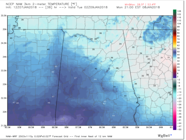
12Z NAM has ice storm warning criteria for Chattanooga and Hamilton County
BPATL
Member
The CAD is already starting in Georgia.....
http://weather.uga.edu/?content=si&variable=XT&title=Air Temperature
http://weather.uga.edu/?content=si&variable=XT&title=Air Temperature
GeorgiaGirl
Member
The NAM was too wet on a few runs but the short range models were closer to reality than the global models with the last storm (except the Euro which got a clue late). There was light accumulating snow in Waynesboro, about 15 miles away from me which was not depicted by any global outside of the Euro.
I'd take what the NAM says and cut it in half.
I'd take what the NAM says and cut it in half.
0.26" in half is 0.13" ice accretion
DadOfJax
Member
Remember the phrase..."The air was just too dry".
BPATL
Member
Not a good sign for the ATL...
CoreyTheSecond
Member
Hopefully the dry air will prevent hardly any precip from reaching the ground in Atlanta. Will be a true nowcasting situation with this one.
0.26" in half is 0.13" ice accretion
But also remember that not all of the ZR accretes to the trees and power lines since a portion drips to the ground before it gets a chance to freeze but a higher % does accrete (though still not 100%) when it is falling lightly as is progged. Regardless, I see the risk for at least N GA to be much more for dangerous travel than for power outages should ZR occur as qpf isn't heavy enough for that kind of worry.
Last edited:
CoreyTheSecond
Member
Fwiw, the 12Z Euro has substantially more qpf for N AL to the ATL area, especially NW burbs. This is obviously a big outlier, especially for the ATL area.
How much qpf for Atlanta?
How much qpf for Atlanta?
Take with a humongous grain since it is a big outlier, but it has 0.50-0.55" in your area, which would be enough for power concerns.
Corey, did you by chance do some ice dancing today?
That's interesting Larry. Wonder why so much? Changes at H5?Take with a humongous grain since it is a big outlier, but it has 0.50-0.55" in your area, which would be enough for power concerns.
Corey, did you by chance do some ice dancing today?
CoreyTheSecond
Member
Take with a humongous grain since it is a big outlier, but it has 0.50-0.55" in your area, which would be enough for power concerns.
Corey, did you by chance do some ice dancing today?
I can't help it. I wanna see anything that is frozen. LOL. JK.....I really didn't. BTW, my area got almost 10 inches of snow during the last storm. I didn't have any socks though so it was really tough to stay out for more than a few hours. Plus my shoes were made of a paper type material so my feet were always wet. But, I actually don't want any ice in reality. The concept seems exciting, but really I dont want any ice. Nothing but problems.
bud006
Member
Just read FFC AFD ... WW Advisory sounds like it is going to be expanded. South to Heard Cty., across south metro then up I-85 through Banks and Jackson counties.
—30–
Sent from my iPhone using Tapatalk
—30–
Sent from my iPhone using Tapatalk
That's interesting Larry. Wonder why so much? Changes at H5?
Yes to some extent.
Psalm 148:8
Member
- Joined
- Dec 25, 2016
- Messages
- 235
- Reaction score
- 420
I’ve seen it forecasted not to get to lagrange but many times it does... i will be cking radars for sure. Again... reason is because wedge verifies stronger than models picked up on..
CoreyTheSecond
Member
I’ve seen it forecasted not to get to lagrange but many times it does... i will be cking radars for sure. Again... reason is because wedge verifies stronger than models picked up on..
Lagrange is always a surprise with wedge situations. They are never in the forecast yet half the time they end up getting ice lol. It's the literal "wedge cutoff" in many CAD events.
Well from me north would be icy if we got moisture in here