Goofus is running
-
Hello, please take a minute to check out our awesome content, contributed by the wonderful members of our community. We hope you'll add your own thoughts and opinions by making a free account!
You are using an out of date browser. It may not display this or other websites correctly.
You should upgrade or use an alternative browser.
You should upgrade or use an alternative browser.
bud006
Member
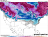
Per 12z Euro (not being talked about yet) these wind gusts would be problematic for areas that receive ice:

Thanks for posting the wind map. Anytime there is an ice threat for the area north and northeast of Atlanta, I worry about winds.
Our trees have taken a beating the past four months, from Irma and the heavy wet snowfall. That amount of ice on those trees with any type of steady breeze concerns me greatly.
—30—
Sent from my iPhone using Tapatalk
Xtreme Weather
Member
HP little farther SE through 90 vs 12z
Webberweather53
Meteorologist
Damn lol you'd probably even have some light snow in the midlands at the onset if that verifiedJeeze, the Euro control (which is lighter than most members in regards to precip totals) has the 32F line to the SC coast:

Snowflowxxl
Member
The gfs continues to look more and more embarrassing
Webberweather53
Meteorologist
Lets just remember only a few short days ago the GFS was dumping a trough into the Rockies and sending this storm into the Midwest and Great Lakes. Oops lol
You can see the difference at 5H out west with energy 18Z GFS vs NAM


Sent from my SM-N950U using Tapatalk


Sent from my SM-N950U using Tapatalk
Cary_Snow95
Member
While the 18z mostly sucks it did slightly amp the sw as it moved across the midwest

Flurry
Member
Great map.
Whose profile did you use to draw that?? LOL
Sent from my iPhone using Tapatalk
Stormlover
Member
packfan98
Moderator
Big step back on the 18z GEFS by looking at the snow depth mean on pivotal. Someone else can fill us in on what’s going on when the individual panels come out.
Edit: my guess is more suppressed solutions like the op. The huge totals for the MA went poof! As Webber said previously, the ensembles will often mirror the op, because there are not enough perturbations programmed into the ensembles. I think.
Edit: my guess is more suppressed solutions like the op. The huge totals for the MA went poof! As Webber said previously, the ensembles will often mirror the op, because there are not enough perturbations programmed into the ensembles. I think.
Snowflowxxl
Member
At this point it’s good too see the GFs not showing a thing. Model is so bad you don’t want it showing anything until 2 dads out
Big step back on the 18z GEFS by looking at the snow depth mean on pivotal. Someone else can fill us in on what’s going on when the individual panels come out.
You're looking too far in advance. Their maps start to remove accumulation the further you get out from them storm. Here is what it looks like for this event: (these maps try to use an algorithm to remove ice/sleet) but it isn't fool proof.. so its still an icy mess per this:
Attachments
Stormsfury
Member
Damn lol you'd probably even have some light snow in the midlands at the onset if that verified
That's quite probable with the wedging/AG signature that strong, the SFC FZ line gets that close to the coast. OP EURO pulls KCHS down to 34 at 06z 12-29, before warming back up to 40 during the afternoon. We all know under steady precip and channeled NNE winds don't allow that even down in my world❄
pcbjr
Member
Hope this is appropriate ... but here goes ...Big step back on the 18z GEFS by looking at the snow depth mean on pivotal. Someone else can fill us in on what’s going on when the individual panels come out.
1) It's 18Z
2) The Pac is so screwy models are just spitting out junk (GIGO)
3) Trends are the key (and IMHO, looking back over 5 days, trends are not supporting anything colossal - only seasonal)