Great they just pulled you into full complaint mode when you don't get a severe storm today
-
Hello, please take a minute to check out our awesome content, contributed by the wonderful members of our community. We hope you'll add your own thoughts and opinions by making a free account!
You are using an out of date browser. It may not display this or other websites correctly.
You should upgrade or use an alternative browser.
You should upgrade or use an alternative browser.
Severe 2023 Spring Severe
- Thread starter SD
- Start date
- Status
- Not open for further replies.
Avalanche
Member
I’m gonna lose whatever marbles I have leftGreat they just pulled you into full complaint mode when you don't get a severe storm today
Shaggy
Member
The hrrr did really good a couple weeks ago and was really close to what happened.The Hhhrrrrr was showing run after run storms for Sunday, while the 3k was showing zilch. Now, it's the opposite. I'm usually inclined to discount the HhrrrrRR any chance I get. That said, there just doesn't look to be a favorable setup for widespread coverage.
Scattered showers/storms with maybe a severe cluster somewhere in the east seems reasonable. 30% --> 50% central to east looks right to me.
Brick Tamland
Member
You know it.Great they just pulled you into full complaint mode when you don't get a severe storm today
znel52
Member
12z NAM 3K coming in quite a bit weaker overall. NE NC still looks to at least get something but it is borderline nothing burger for SE NC. Looks like their *could* be a couple of small cells. Lame.
znel52
Member
Also, KMHX is down for roughly a month due to Pedestal Maintenance. Us crystal coasters will have to use KLTX or KRAX for any radar viewing.
Brick Tamland
Member
WRAL 's Mike Maze posted this on Facebook.
WRAL WEATHER ALERT DAY: We are starting to see showers pop up on the DD5K which could be the start of the storms for this afternoon. Still waiting for a Severe Thunderstorm Watch to be issued. It's watch and wait mode!
WRAL WEATHER ALERT DAY: We are starting to see showers pop up on the DD5K which could be the start of the storms for this afternoon. Still waiting for a Severe Thunderstorm Watch to be issued. It's watch and wait mode!
Brick Tamland
Member
And just got an alert for a lightning strike 6 miles away. Looks like things are starting to fire up now.
znel52
Member
Not an exact match but initiation looks more like what the HRRR and most other mesoscales were showing and less like the NAM. Doubting the MCS idea playing out at the moment.
Downeastnc
Member
Not an exact match but initiation looks more like what the HRRR and most other mesoscales were showing and less like the NAM. Doubting the MCS playing out.
Yeah not seeing the big cluster forming in VA just yet.....needs to get popping soon if its going to keep the timing the hi res had....
Brick Tamland
Member

Downeastnc
Member
Going to have to see how it plays out, pretty nasty cell moving into Pitt Co, worse looks to miss me west though....
Brick Tamland
Member
Severe Thunderstorm Warning for...
Northeastern Greene County in eastern North Carolina...
Central Pitt County in eastern North Carolina...
* Until 430 PM EDT.
* At 341 PM EDT, a severe thunderstorm was located 9 miles southeast
of Elm City, or 11 miles northwest of Farmville, moving east at 30
mph.
HAZARD...60 mph wind gusts and quarter size hail.
SOURCE...Radar indicated.
IMPACT...Hail damage to vehicles is expected. Expect wind damage
to roofs, siding, and trees.
* Locations impacted include...
Greenville, Winterville, Farmville, Bell Arthur, House, Bruce, East
Carolina University, Pitt Greenville Airport, Dowdy Ficklen
Stadium, Fountain, Simpson, Walstonburg and Falkland.
znel52
Member
Oof

Sent from my SM-S918U using Tapatalk

Sent from my SM-S918U using Tapatalk
znel52
Member
Oh alright then 

Sent from my SM-S918U using Tapatalk


Sent from my SM-S918U using Tapatalk
weatherfide
Member
- Joined
- Jan 5, 2017
- Messages
- 3,078
- Reaction score
- 4,501
Whopper sized hail at my house this afternoon!

Downeastnc
Member
My wife is in Ayden and looks to get some big hail I tried to convince her to leave work early to get the car out there lol....
Shaggy
Member
I live near the black dot near those three lightning strikes and they were brown pants level close.Oh alright then
Sent from my SM-S918U using Tapatalk
Attachments
znel52
Member
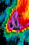
That cell is just a beast. Don't get too many of them around here. Got a 72.5dbz on another scan.
Sent from my SM-S918U using Tapatalk
Sent from my SM-S918U using Tapatalk
Shaggy
Member
The hail we got was mostly dime with a few pennies. Bet it was way bigger than that a mile or two to my south. Damage report at Ballard's crossroads and a house fire that's about 2 miles to my southwest
- Status
- Not open for further replies.