• Hello, please take a minute to check out our awesome content, contributed by the wonderful members of our community. We hope you'll add your own thoughts and opinions by making a free account!

Tropical 2019 Atlantic Hurricane Season & Model Discussion

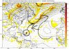
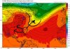
The 6Z GEFS continues with the idea of a very good chance at a similar recurve to what the 0Z GEFS favors but unlike the 0Z GEFS threatens the CONUS with a strong H with ~20% of its members: 10% in Gulf and 10% close to the east coast (1 FL and 1 NC). The 0Z EPS is kind of similar to the 6Z GEFS.

Therefore, what the overall model consensus has been telling me since yesterday is to favor a recurve east of the CONUS but not to bet strongly on it at this early stage as there’s probably something like a 1 in 4 chance for the CONUS to be hit. So, I’ll keep watching this closely at least for the next few days. I’d like to at least get a better idea of the expected genesis location and timing as there’s still a lot of uncertainty there.
 
Last edited:
It may not be nothing big or anything at all, but we may want to watch the gulf by this weekend. Low pressure tries to form in the gulf. Icon has it as tropical storm euro tries also and gfs tries something as well. Regardless, it will bring beneficial rain to the southeast which is a great thing.
 
Figure it would give us something to do lol. Is there a thread for this one? If not I'll post here.
icon_mslp_pcpn_frzn_seus_48.png
 
For the yet tbd system but yeah GFS just flipped the script....

View attachment 23314

It’s gonna be hard to get a trough to come down and sweep it OTS as long as energy keeps dropping in the west. The best chance here is like the Euro had a day or so ago where a trough digs on the east side of the WAR and pulls it east of Bermuda.
 
The actual GFS shows this scenario well. IMO this is probably the only escape route. Does the trough create enough weakness to grab it before the ridge builds back in.
 

Attachments

  • 23F4A11C-A775-4EE7-9B5B-53FBAEC0831B.jpeg
    23F4A11C-A775-4EE7-9B5B-53FBAEC0831B.jpeg
    400.7 KB · Views: 33
The actual GFS shows this scenario well. IMO this is probably the only escape route. Does the trough create enough weakness to grab it before the ridge builds back in.

This looks very familiar.
 
You can see it the escape route on the Euro again. If the ridge can break down enough, it can go OTS. If it tucks in under the east US ridge, here it comes.
 

Attachments

  • 19AAF395-EDF8-4AB6-8571-9D50C76FC724.jpeg
    19AAF395-EDF8-4AB6-8571-9D50C76FC724.jpeg
    336.8 KB · Views: 32
You can see it the escape route on the Euro again. If the ridge can break down enough, it can go OTS. If it tucks in under the east US ridge, here it comes.
Either you or GaWX mentioned last week (maybe), Euro tends to stiffen the ridge and GFS tends to break it down too much....I think?
So looking at 12z version of each and eyeball those changes....they are not as far apart as you think to CONUS landfall in the same general area.
 
Opposite to what I thought....Interesting....


1. The SSTs didn't cool much off the SE coast and they're already warming back up thanks largely to a very hot SE. For example, KSAV just had the 3rd 97 in a row.

2. I'm actually more concerned about a storm going into the Gulf. IF the next storm tracks through the western Caribbean and Gulf, it would be going through water that hasn't been tapped in quite awhile and there also have been no sig cold fronts to cool the waters thus leaving it very hot. The SSTs are boiling...I mean nearly 1 C warmer than they were just before Michael came through in some areas! Most of the open Gulf and W Caribbean is ~86-87 range with some open areas even close to 88! Just before Michael, it was at or near record warm for early Oct., but even that was more like 84-6. Also to compare, the warmest open ocean SSTs in Dorian's path were near 86-7 (Bahamas). That's quite concerning, especially if it is not crawling slowly enough to lead to weakening due to its own wake.
Unless that wave now north of the Greater Antilles were to develop much and cool the Gulf some, the Gulf will likely still be about this hot if the far E Atlantic entity were to track this way as I don't see any sig cold fronts during the next 14+ days with well above normal temps continuing.
 
Last edited:
1. The SSTs didn't cool much off the SE coast and they're already warming back up thanks largely to a very hot SE. For example, KSAV just had the 3rd 97 in a row.

2. I'm actually more concerned about a storm going into the Gulf. IF the next storm tracks through the western Caribbean and Gulf, it would be going through water that hasn't been tapped in quite awhile and there also have been no sig cold fronts to cool the waters thus leaving it very hot. The SSTs are boiling...I mean nearly 1 C warmer than they were just before Michael came through in some areas! Most of the open Gulf and W Caribbean is ~86-87 range with some open areas even close to 88! Just before Michael, it was at or near record warm for early Oct., but even that was more like 84-6. Also to compare, the warmest open ocean SSTs in Dorian's path were near 86-7 (Bahamas). That's quite concerning, especially if it is not crawling slowly enough to lead to weakening due to its own wake.
Unless that wave now north of the Greater Antilles were to develop much and cool the Gulf some, the Gulf will likely still be about this hot if the far E Atlantic entity were to track this way as I don't see any sig cold fronts during the next 14+ days with well above normal temps continuing.
To your point...."Gulf of Mexico just endured its hottest June ever, new report says"
BY CAITLIN LOOBY | STAFF WRITER JUL 19, 2019 - 12:32 PM

https://www.nola.com/news/environment/article_38d15394-aa4b-11e9-be4a-0b43e9e22441.html
 
Back
Top