accu35
Member
12z gfs trending better


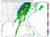
Given my closest weather station, seems very much spot on with GVL (closest station to me in that map). Right now, I'm at 40 degrees with a wetbulb of 31, so if that doesn't go up, we could see some icing early tomorrow.The 3km NAM's surface dew points are off by about 10F area wide across much of upstate SC and NC. Supposed to be around the low-mid 10s already here in Charlotte, our dew point is near 0F.
View attachment 12614
View attachment 12615
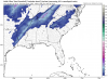
It's not really a storm, it's cold chasing moisture scenario. For most, nothing significant, mostly just flurries. Short range models do not show much in the way of frozen precip. Maybe better snow accumulations across TN/KY and the mountains.Does this storm still have legs or have forecast models backed off? Local Mets aren’t talking about it.
Given my closest weather station, seems very much spot on with GVL (closest station to me in that map). Right now, I'm at 40 degrees with a wetbulb of 31, so if that doesn't go up, we could see some icing early tomorrow.


18z 3k-Nam
View attachment 12617
Last time I checked, mine was 3!!!! Solid stratocumulos now! Winds steady 5-10 from the NE! They were supposed to be SE by now!The 3km NAM's surface dew points are off by about 10F area wide across much of upstate SC and NC. Supposed to be around the low-mid 10s already here in Charlotte, our dew point is near 0F.
View attachment 12614
View attachment 12615

I meant to fix your username ill do that tonightSouthend Charlotte (close to Uptown)
Sent from my iPhone using Tapatalk
Hey, I'll be excited just to see flurries LOL. I'm more excited about next weekIt's not really a storm, it's cold chasing moisture scenario. For most, nothing significant, mostly just flurries. Short range models do not show much in the way of frozen precip. Maybe better snow accumulations across TN/KY and the mountains.


39/8 no legs. RH will rapidly rise before precip gets here and WB will be 32.4Current wet bulb 30.72
legs?
healthy cloud cover in Possum Kingdom right now39/8 no legs. RH will rapidly rise before precip gets here and WB will be 32.4


Cess is blending the warmest and driest model apparently. Can’t blame him18z GFS, very mehView attachment 12629
KK makes me want to kick kittens and baby ducks!Cess is blending the warmest and driest model apparently. Can’t blame him
Is KK calling for 50 and sunny at midnight?KK makes me want to kick kittens and baby ducks!