• Hello, please take a minute to check out our awesome content, contributed by the wonderful members of our community. We hope you'll add your own thoughts and opinions by making a free account!

Wintry Winter 26-27

I did not realize it was that low.

Hard to get really big storms here. Just like last year and the 2 feet models. There was always an issue with how unusual that would have been. Some years it's just a bunch of little events(like January 1979 when it snowed nearly everyday). Had a foot that month but it was so spread out

The year we had 26 also had the blizzard with 14 inches which is the biggest snowstorm on record here

At least it's happened in the 2000s though!

6-12 seems to be our high end most years like last year and that's also how February 2021 was

And even then 2 weeks later it was in the 70s and all that was left was the dirty piles

That seems to be the other thing when we do get a really big storm it seems to warm up and be spring like for awhile at some point
 
Last edited:
BamWx says it's going to be a record-warm winter. But the best chances for big snows, meaning more than one, are from Texas to the Mid-Atlantic, centered in the Mid-South and extending into the Carolinas! With that said, I was driving and watching as best I could, so I think I got it right for the most part. lol
 
BamWx says it's going to be a record-warm winter. But the best chances for big snows, meaning more than one, are from Texas to the Mid-Atlantic, centered in the Mid-South and extending into the Carolinas! With that said, I was driving and watching as best I could, so I think I got it right for the most part. lol

186a4d6f686b7b593aadbfc2bd89a405.png


Sent from my iPhone using Tapatalk
 
BamWx says it's going to be a record-warm winter. But the best chances for big snows, meaning more than one, are from Texas to the Mid-Atlantic, centered in the Mid-South and extending into the Carolinas! With that said, I was driving and watching as best I could, so I think I got it right for the most part. lol
He’s right about as much as Judah and JB, so buy a sled!
 
We shall wait and see up here, but this local met gave me some hope…… ⛄️ IMG_6626.png
 
1bb92f9447d93bbed5b4bdc988ad0b3f.webp

0b1c80e9f4dbcb4f97ac1e1288d5bd7e.webp

ca31c5154965ff7370d118264637da8e.webp

Here’s the Sept Euro seasonal DJF snowfall forecast for the mid Atlantic/southern Appalachians, credit to SW Europe for the maps.


Sent from my iPhone using Ta

Doesn’t have to be a cold winter to get winter storms just have to have things work out correctly


Sent from my iPhone using Tapatalk
Especially higher elevations. I'm thinking NC, VA mountains might do well.
 
My bet is on a warm winter .
Bet the house
El Niño winter means the overall average temperature trends higher, which does not stop short arctic blasts or freezing days from happening. Depends on what we are looking at by DJF of the strength of El Nino. I say all types of precipitation will form this winter, and there will be chances of winter storms just as well as severe weather.
 
El Niño winter means the overall average temperature trends higher, which does not stop short arctic blasts or freezing days from happening. Depends on what we are looking at by DJF of the strength of El Nino. I say all types of precipitation will form this winter, and there will be chances of winter storms just as well as severe weather.
Yes that statement works every winter.
 
Keep in mind that every El Nino or La Nina episode has its own characteristics. You would think that with a basin-wide and strong +ENSO signal, the classic jet stream configuration of very strong polar westerlies would be showing up on the numerical models. Instead, most of the forecast schemes and ensemble members are keying in on a -AO/+PNA type alignment that keeps ridging over Alaska and the western/northern portions of North America. The former set-up of a potent heat ridge in the south central states is gone for good, and within ten days the characteristic spread of hotter temperatures at surface will be gone as well. I will get right to the critical point: if we do not see the "usual" split flow signature of a California/Texas/Georgia storm track and a lateral spread of very mild readings through southern Canada and the northern half of the USA, an alteration of forecast above normal values and dry conditions above 40 N Latitude is very likely to take shape in the lower 48 states. For now I am leaning toward a cool October and November, a warm December/early and central January, then a cold turn for February and March 2027.

Precipitation chances should be more widespread over the eastern 2/3 of the USA, and with ridging in the West and across far northern Canada/Alaska, cool but not cold air will be on order from the High Plains to the Appalachian Mountains. Most of the storms would ride from TX/LA to GA/FL and then northeast past Cape Hatteras NC, following the warm waters of the Gulf Stream. The pulsing of the Madden-Julian Oscillation and the injection of Typhoon Surigae into a sub-Aleutian mPk vortex are cold indicators for North America, which is the kind of scenario that last happened in 2014 (the famed "OctSnowber" that led to record cold in the DJFM winter season). The hydrothermal measures in the equatorial Pacific Basin are closest to 1997, for most locales a mild fall and winter that cooled in February and March of 1998.

What this all means is that the many reports of the current El Nino are often deficient with one truth. That is, the importance of this event lies not in its numbers and indices, but what happens in actual weather that affects real people. And to get a clearer picture of what should transpire. That might well mean a very stormy alignment in much of Texas that will give way to a colder look in the third or fourth week of January.


Prepared by Meteorologist LARRY COSGROVE on
Sunday, September 27, 2026 at 3:00 A.M. CT
​
 
Per Robert: Potentially some hope for this winter. Wait and see how this shakes out over next 8 weeks. Could just be a coincidence. Time will tell.


"Interesting that things want to amplify this strongly, and this early in October (and to see negative NAO showing up again). It reminds me of the active El Nino of 2009-10 that got off to a fast and wild start, and we were rocking and rolling by December back then. We’ll see."
 
Per Robert: Potentially some hope for this winter. Wait and see how this shakes out over next 8 weeks. Could just be a coincidence. Time will tell.


"Interesting that things want to amplify this strongly, and this early in October (and to see negative NAO showing up again). It reminds me of the active El Nino of 2009-10 that got off to a fast and wild start, and we were rocking and rolling by December back then. We’ll see."
Robert from WxSouth?
 
Really I think we can hope for a Negative NAO then we will be in business this winter it did work in 2015-2016


Sent from my iPhone using Tapatalk
 
Going be big problem with super Nino. Getting that nao go in the negative range for a period

It wasn’t a problem in 2015-2016 it was a Super El Niño then. I’m just saying that it’s not impossible we don’t have some opportunities for winter weather this year!


Sent from my iPhone using Tapatalk
 
Per Robert: Potentially some hope for this winter. Wait and see how this shakes out over next 8 weeks. Could just be a coincidence. Time will tell.


"Interesting that things want to amplify this strongly, and this early in October (and to see negative NAO showing up again). It reminds me of the active El Nino of 2009-10 that got off to a fast and wild start, and we were rocking and rolling by December back then. We’ll see."
Yep when you look at a good amount of our strong ninos and you isolate out years like 82, 97, 15 most of those winters feature some type of hyper amplification. The better part is most of those years featured legitimate arctic cold for us when the jet retracted and the pac ridge went poleward. The biggest challenges we have seen in most of our supers really hasn't been cold or moisture its been warm moist then strong cold front overbearing NW flow then repeat. The upcoming pattern with the western ridge is a good sign but then again most of the super ninos lean cold so it's not a leading indicator for winter.
 
Last edited:
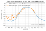
I find it interesting that the high Arctic continues to follow the trend of being below average as it has since May. In fact, the region hasn't been this cold heading into October in more than twenty years. (2010 & 2011 are close)

If nothing else, this has to be good for an early refreeze of the polar ice cap and promotes October Siberian snow cover growth. Not saying this means a cold winter, but it's interesting nonetheless.
1790688620634.png
 
I find it interesting that the high Arctic continues to follow the trend of being below average as it has since May. In fact, the region hasn't been this cold heading into October in more than twenty years. (2010 & 2011 are close)

If nothing else, this has to be good for an early refreeze of the polar ice cap and promotes October Siberian snow cover growth. Not saying this means a cold winter, but it's interesting nonetheless.
View attachment 198335
Really don’t have much effect on our winters. Look at some past records to see that
 
Really don’t have much effect on our winters. Look at some past records to see that
"Look at some past records to see that"

Do you have some data to share? Are you just guessing?

The last time the high Arctic was not above average in this time frame was the 80s through the early 90s. I seem to recall some great winters back then. And 2011 wasn't too shabby either.
 
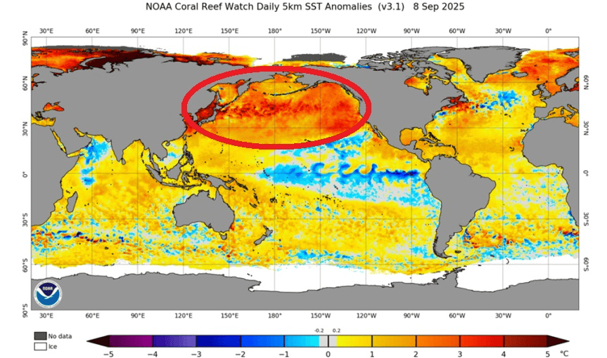
Of course I'm hoping for snow this year. I keep hearing folks talk about the northwest Pacific water temps. It is unusually warm, whereas it is normally cold(er) with an emerging el nino. The hope is it will help Aleutian (Islands) lows to setup this winter. This would (in tern) help build west coast ridging (+PNA). Here's a September 16th article. It's focused on Minnesota, but still relevant:


Edit: That article is from last year, but still defines what we're looking for. Here's an animation of the current Pacific water temps, which shows the warmth continuing in the NW regions.

 
Last edited:
Of course I'm hoping for snow this year. I keep hearing folks talk about the northwest Pacific water temps. It is unusually warm, whereas it is normally cold(er) with an emerging el nino. The hope is it will help Aleutian (Islands) lows to setup this winter. This would (in tern) help build west coast ridging (+PNA). Here's a September 16th article. It's focused on Minnesota, but still relevant:


Edit: That article is from last year, but still defines what we're looking for. Here's an animation of the current Pacific water temps, which shows the warmth continuing in the NW regions.

That's last year. The PDO has flipped negative. Which, btw is different than the 1997 "super El Niño when the PDO was strongly positive.
1790692751074.png
 
"Look at some past records to see that"

Do you have some data to share? Are you just guessing?

The last time the high Arctic was not above average in this time frame was the 80s through the early 90s. I seem to recall some great winters back then. And 2011 wasn't too shabby either.

Thanks for posting this. 2026 having it this cold N of 80N on Sep 28th is per this site technically the coldest this early in the season in 30 years, quite notable! I say “technically” though because it only barely beat 2011 (as you implied), 2004, and 2000.

Regardless, the most interesting comparison is to 2012-25, which were all much warmer/AN on Sep 28th:

1958-2002 mean: -11C
26: -13C

25: -7C
24: -9C
23: -8C
22: -7C
21: -8C
20: -5C
19: -5C
18: -5C
17: -8C
16: -7C
15: -8C
14: -7C
13: -9C
12: -9C
2012-25 mean: -7C

So, regarding Sep 28th, 2026 is:
1. 4-8C colder than every year since 2012
2. 6C colder than the mean of 2012-2025!

I’m not saying it necessarily means much for the winter of 2026-7. Also, yes, I’m only talking in this post about a point in time and 80N+ is a small area in relation to the globe. But that area is just coming off the coldest late May-early Aug back to 1958 by a good margin. So, perhaps this overall cooling up there will have legs. I’ll keep following this to see if there’s chilly follow-through going ahead as this is quite interesting on its own up there, especially due to its implications on Arctic ice since GW had lead to the greatest warming by a good margin in the Arctic.
 
Last edited:
That's last year. The PDO has flipped negative. Which, btw is different than the 1997 "super El Niño when the PDO was strongly positive.
View attachment 198336
Ryan Hall talked about this departure from normal with the PDO being negative in the pacific this year (versus the regular +PDO association for El Nino conditions) and tied it back into the potential implications for winter conditions in the eastern US. Based on my limited understanding of teleconnections, the +PDO is much more prevalent during El Nino with the -PDO during La Nina. Over the most recent La Nina episodes, we can all agree that there have been notable and sharp cold fronts from more amplification of the Jet Stream than during El Nino seasons when a more consistent pattern can establish itself for a longer time.

Basically what Ryan Hall said was that the -PDO could associate with more activity of troughing in the eastern US, particularly with a tendency to provide more ample and frequent cold shots unlike a typical El Nino, and given the STJ which will be screaming through the southern US, the background probability that a significant winter storm occurs with this patten increases. Essentially, the -PDO may be providing more cold shots in this El Nino than typically would be expected, and this in turn increases the probability of an overlap.

Now I do not have enough background knowledge to back this up significantly, but can say I could see this correlation between -PDO and active La Nina cold shots (which I have seen over these past few years) working towards providing an increased chance of moisture overlapping cold air since the STJ will be more stubborn to scour out unlike during La Nina episodes. We will have to wait and see how this pans out, but I am more optimistic than I have been in prior outlooks for increased winter weather chances.
 
Thanks for posting this. 2026 having it this cold N of 80N on Sep 28th is per this site technically the coldest this early in the season in 30 years, quite notable! I say “technically” though because only it barely beat 2011 (as you implied), 2004, and 2000.

Regardless, the most interesting comparison is to 2012-25, which were all much warmer/AN on Sep 28th:

1958-2002 mean: -11C
26: -13C

25: -7C
24: -9C
23: -8C
22: -7C
21: -8C
20: -5C
19: -5C
18: -5C
17: -8C
16: -7C
15: -8C
14: -7C
13: -9C
12: -9C
2012-25 mean: -7C

So, regarding Sep 28th, 2026 is:
1. 4-8C colder than every year since 2012
2. 6C colder than the mean of 2012-2025!

I’m not saying it necessarily means much for the winter of 2026-7. Also, yes, I’m only talking in this post about a point in time and 80N+ is a small area in relation to the globe. But that area is just coming off the coldest late May-early Aug back to 1958 by a good margin. So, perhaps this overall cooling up there will have legs. I’ll keep following this to see if there’s chilly follow-through going ahead as this is quite interesting on its own up there, especially due to its implications on Arctic ice since GW had lead to the greatest warming by a good margin in the Arctic.
Perhaps most impressively, we have to go back to a time when the summer ice retention was far greater to sniff these temps. Interestingly, I couldn't find any summer season when the average temperature (June-August) failed to get above 0 °C.
 
Ryan Hall talked about this departure from normal with the PDO being negative in the pacific this year (versus the regular +PDO association for El Nino conditions) and tied it back into the potential implications for winter conditions in the eastern US. Based on my limited understanding of teleconnections, the +PDO is much more prevalent during El Nino with the -PDO during La Nina. Over the most recent La Nina episodes, we can all agree that there have been notable and sharp cold fronts from more amplification of the Jet Stream than during El Nino seasons when a more consistent pattern can establish itself for a longer time.

Basically what Ryan Hall said was that the -PDO could associate with more activity of troughing in the eastern US, particularly with a tendency to provide more ample and frequent cold shots unlike a typical El Nino, and given the STJ which will be screaming through the southern US, the background probability that a significant winter storm occurs with this patten increases. Essentially, the -PDO may be providing more cold shots in this El Nino than typically would be expected, and this in turn increases the probability of an overlap.

Now I do not have enough background knowledge to back this up significantly, but can say I could see this correlation between -PDO and active La Nina cold shots (which I have seen over these past few years) working towards providing an increased chance of moisture overlapping cold air since the STJ will be more stubborn to scour out unlike during La Nina episodes. We will have to wait and see how this pans out, but I am more optimistic than I have been in prior outlooks for increased winter weather chances.
Just not seeing it be honest , this winter will be filled with pacific air pumping into the pattern with strong pacific jet influenced by this suoer Nino… which is on pace to blow the other strong El Niños out of the water .
 
Just not seeing it be honest , this winter will be filled with pacific air pumping into the pattern with strong pacific jet influenced by this suoer Nino… which is on pace to blow the other strong El Niños out of the water .
You have never called for cold or snow even when it was cold and snowing.
 
Just not seeing it be honest , this winter will be filled with pacific air pumping into the pattern with strong pacific jet influenced by this suoer Nino… which is on pace to blow the other strong El Niños out of the water .
What’s your call for Jackson, TN this winter? Any frozen precip events? Do you really think warm pacific air from December- March?

I’ll do Huntsville, I know I’ll be wrong but fun to try.

December: 2°F above normal. No winter weather events.


January: 1° F below normal. Small snowfall for MLK day.

Feb 2°F below normal. Two events, one bigger >4”.

March- one more good shot. It snowed like a whiteout for 10 mins on March 16 this year, it was 36° and melted immediately. If it did it once, it can do it better next time.


Good luck to us all.
 
Back
Top