How would you guys rank things in level of importance from the following for us to have a nice winter?
PDO going positive
+PNA
EPO
North Atlantic Blocking
STJ (seems like moisture won’t be a problem this year)
Anything else?
PNA is #1 for the SE.

How would you guys rank things in level of importance from the following for us to have a nice winter?
PDO going positive
+PNA
EPO
North Atlantic Blocking
STJ (seems like moisture won’t be a problem this year)
Anything else?

PNA is #1 for the SE.
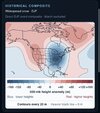
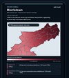 New research compiled on Dr. Jonathan Wall’s Snow Signal website emphasizes the statistical probability increase of snowfall when a +PNA is present. It trumps the significance of every other teleconnection. This is not only for East Tennessee, but for many other CWA’s in the Southeast.

Travis Weather on the 'nino
I think he lives in Virginia he's not an on air meteorologist at the moment though. He was a meteorologist in the past though.Thanks. Interesting. For what location is Travis a met.?
Travis Weather on the 'nino
From Tazewell I believe. Great place for snow in SW Virginia. Burke's Garden at 3100' had 42 inches last Winter. Plenty of upslope there.I think he lives in Virginia he's not an on air meteorologist at the moment though. He was a meteorologist in the past though.
I think most higher elevation areas will do great this year. The biggest concern for a lot of us will be how much cold will pair with each storm system. But, as long as the storm track stays south of the mountain areas, the higher locations should be good for many opportunities. I'll be taking a lot of Boone trips this year.From Tazewell I believe. Great place for snow in SW Virginia. Burke's Garden at 3100' had 42 inches last Winter. Plenty of upslope there.
Might be a good Winter to be North and WestI think most higher elevation areas will do great this year. The biggest concern for a lot of us will be how much cold will pair with each storm system. But, as long as the storm track stays of the mountain areas, the higher locations should be good for many opportunities. I'll be taking a lot of Boone trips this year.

Might be a good Winter to be North and West


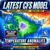

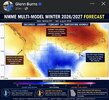

I saw where he expected early SPV disruptions as well.GB delivering our pre season fixView attachment 197593


I know December 1997 was very active for snow lovers across the Deep South. There was the big snow event in MS and AL in Mid December and in Late December there was a snow event for Georgia. The rest of the winter sucked though.I was looking at winter storm data from the winters of 1982-1983 and 1997-1998 which had very strong El Ninos close to the record event that is being predicted and both years Central North Carolina did see at least one event with accumulating winter precipitation. In 1982-1983 Raleigh had a January storm that produced around two inches at RDU and in March a storm dumped seven inches and even larger totals east of the Triangle. Then came the latest accumulating snow on record at RDU on April 18, 1983.
In the winter of 1997-1998, Raleigh got one significant winter weather event in mid January with around eight inches being recorded at RDU. I know that history doesn't exactly repeat itself with El Nino weather events but after looking at this it makes me more optimistic that the record El Nino might not be the harbinger of doom that shuts down winter weather in Central North Carolina.
Do you know anything about February 1998? Specifically on the 4th, I see the ECMWF ERA5 historical reanalysis with an upper low snow type feature during the morning hours over mainly the NW part of the state, but beyond that mostly confined to apps and points north and west. Couldn’t find any documentation of this in GA after a quick search. Perhaps it was borderline temps but mostly rain down in the southern extent regions?I know December 1997 was very active for snow lovers across the Deep South. There was the big snow event in MS and AL in Mid December and in Late December there was a snow event for Georgia. The rest of the winter sucked though.
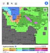
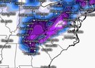
I don’t remember any snow in Carrollton in February 1998. Just a lot of rain. I’m not sure about further north. That was probably the wettest winter and early spring that I can ever remember.Do you know anything about February 1998? Specifically on the 4th, I see the ECMWF ERA5 historical reanalysis with an upper low snow type feature during the morning hours over mainly the NW part of the state, but beyond that mostly confined to apps and points north and west. Couldn’t find any documentation of this in GA after a quick search. Perhaps it was borderline temps but mostly rain down in the southern extent regions? View attachment 197599View attachment 197600

I believe that one hit early on a weekday morning but I may be confusing it. It wasn't supposed to do much but they finally sent us home from school with several inches on the ground and it still pouring snow. It piled up good but the sun came out and melted it super fast that afternoon.Do you know anything about February 1998? Specifically on the 4th, I see the ECMWF ERA5 historical reanalysis with an upper low snow type feature during the morning hours over mainly the NW part of the state, but beyond that mostly confined to apps and points north and west. Couldn’t find any documentation of this in GA after a quick search. Perhaps it was borderline temps but mostly rain down in the southern extent regions? View attachment 197599View attachment 197600


Agreed it may not be the harbinger of doom, we'll see.I was looking at winter storm data from the winters of 1982-1983 and 1997-1998 which had very strong El Ninos close to the record event that is being predicted and both years Central North Carolina did see at least one event with accumulating winter precipitation. In 1982-1983 Raleigh had a January storm that produced around two inches at RDU and in March a storm dumped seven inches and even larger totals east of the Triangle. Then came the latest accumulating snow on record at RDU on April 18, 1983.
In the winter of 1997-1998, Raleigh got one significant winter weather event in mid January with around eight inches being recorded at RDU. I know that history doesn't exactly repeat itself with El Nino weather events but after looking at this it makes me more optimistic that the record El Nino might not be the harbinger of doom that shuts down winter weather in Central North Carolina.
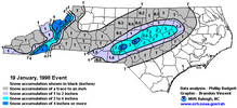


You are correct about the January 19, 1998 storm bringing only two inches of snow to RDU. I should have looked at some maps instead of reading a summary which I didn't read carefully enough. While I feel we will be above normal temperature wise this coming winter, if we can time a cold shot with the abundant moisture El Nino should bring, we can still score and maybe we can score bigtime.Agreed it may not be the harbinger of doom, we'll see.
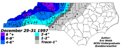
BTW, can you link anything you found about mid Jan 98 at RDU? Couldn't find anything on it. Did find these 2 events from that winter. 1st is this post Christmas NW Piedmont Special (being in W Guilford Co at the time, I remember this one--I actually thought it was more like 7''):
View attachment 197601
Exhibit B: Hwy 1 Minor Special that flips off the NW Piedmont (no recollection on this one--but probably not surprising)
View attachment 197602
Even if RDU did or didn't get 8'' in Jan 98, that winter was actually above average in the 90's. I've said it probably too many times, but the 90's were terrible around here. We all remember 93 and 96 (and 94 wasn't too shabby), but the rest of the decade was mostly something to forget winterwise.
All good. Honestly I was hoping RDU really got that in 98 and I just couldn't find it.You are correct about the January 19, 1998 storm bringing only two inches of snow to RDU. I should have looked at some maps instead of reading a summary which I didn't read carefully enough. While I feel we will be above normal temperature wise this coming winter, if we can time a cold shot with the abundant moisture El Nino should bring, we can still score and maybe we can score bigtime.
Why ? It’s just a big guessing game for nowI wish Bouncycorn did a seasonal forecast!!
That 1997-98 winter also had a significant winter storm in late December between Christmas and New Years for much of the southI was looking at winter storm data from the winters of 1982-1983 and 1997-1998 which had very strong El Ninos close to the record event that is being predicted and both years Central North Carolina did see at least one event with accumulating winter precipitation. In 1982-1983 Raleigh had a January storm that produced two inches at RDU and in March a storm dumped seven inches and even larger totals east of the Triangle. Then came the latest accumulating snow on record at RDU on April 18, 1983.
In the winter of 1997-1998, Raleigh got one significant winter weather event in mid January with two inches being recorded at RDU. I know that history doesn't exactly repeat itself with El Nino weather events but after looking at this it makes me more optimistic that the record El Nino might not be the harbinger of doom that shuts down winter weather in Central North Carolina.
All good. Honestly I was hoping RDU really got that in 98 and I just couldn't find it.
My unprofessional opinion on the super nino stuff. I'll take my chances on above avg QPF over below avg every time. I see it as more chances, but that's just me. I'd rather have 33+ and rain then 20 and bone dry while FL gets an inch. (and that's no offense to FL, but you know)
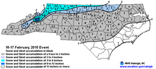
Not bad for some. Fairly pronounced N-S gradient that winter.So was looking it seems that 2014/2015 was a super El Niño as well maybe others have already said that but if I remember correctly NC did pretty well in 2014&2015 overall
Sent from my iPhone using Tapatalk
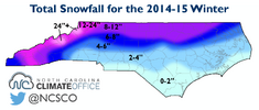

Not bad for some. Fairly pronounced N-S gradient that winter.
View attachment 197634
LOL at that Wake Co gradient.

This is so dumb....He doesn't even have the color scale lined up with the anomalies. What a strange outfit.Bobby in tha building!
I took another look. This season had a lot of minor events scattered throughout Jan into late Feb. The above total's got some skew from this late Feb event.Not bad for some. Fairly pronounced N-S gradient that winter.
View attachment 197634
LOL at that Wake Co gradient.
Edit: Basically NC had a lot of potential that year. Some areas produced, and others missed the opportunity. Probably not a bad analog for this one depending on how it shakes out.
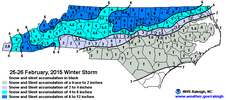
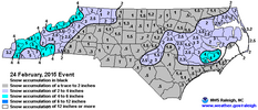

I took another look. This season had a lot of minor events scattered throughout Jan into late Feb. The above total's got some skew from this late Feb event.
View attachment 197635
Interesting enough, there was a "foreshock" 1-2 days before:
View attachment 197637
Long story short, quite a few opportunities that winter FWIW.
2014-2015 was not a strong El Niño. It was scarcely a weak one. Unfortunately it just doesn’t fit into the box for this upcoming season.
It was basically 2014-2016. During November and December 2015 values within NOAA oceanic Nino index peak at 2.3 Celsius which surpassed this number 1997 value of 2.2 Celsius.
Sent from my iPhone using Tapatalk
You are right about any EL Nino that exceeds 2.0 being very strong. The Winter of 1982-1983 is the strongest recorded El Nino event in history for now and it was 2.4 degrees Celsius above normal. WRAL had a good article in their Ask the Meteorologist column yesterday about strong El Ninos and their effects on winter weather in the Triangle that I can not find now.Anything that exceeds 2.0 is very strong
Sent from my iPhone using Tapatalk
Alright, let's toss 1997-1998 since it's in dispute on here. All in on 1982-1983!You are right about any EL Nino that exceeds 2.0 being very strong. The Winter of 1982-1983 is the strongest recorded El Nino event in history for now and it was 2.4 degrees Celsius above normal. WRAL had a good article in their Ask the Meteorologist column yesterday about strong El Ninos and their effects on winter weather in the Triangle that I can not find now.