We barely saw 3ish inches all winter. As soon as it fell it was gone.. and most of it was sleet.The only people complaining should be Raleigh people.

We barely saw 3ish inches all winter. As soon as it fell it was gone.. and most of it was sleet.The only people complaining should be Raleigh people.


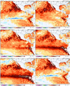
How do you like the Euro seasonal height pattern for January? Looks like a strong STJ, maybe flooding the US with warmth. But....
My guess is that would be the natural order of things for a strong nino; a strong STJ, setting up an Alaskan or western trough (of doom) with an eastern ridge. It'll all come down to the forcing and the jet location as it usually does, but my assumption with a strong nino we tend to get strong STJs that extend too far east, and thus that height pattern that ridges us in the east.
I guess there's always some index or atmospheric element that could limit the jets extent east and save us, but my default guess is an extended jet more than not in the winter.


I can't wait for the cold rain and dry slots


Who else is ready for winter?
Sent from my iPhone using Tapatalk

I can’t wait for 35 and rain here and 22 degrees and 8” in Myrtle!I can't wait for the cold rain and dry slots


Can’t wait for less amped and positive tilted garbage
I had a 16” season last year I should shut up lol
Sent from my iPhone using Tapatalk

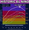

Hope y’all like rain
View attachment 197008
Yes that’s “all” it takes.All it takes is one of those gulf lows getting timed up with an arctic shot... right?



It won't even rain down here anymore.I think @Mitch West still has a right to complain


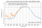
I believe this is significant in its own way. It will allow more cold air to build earlier than usual. With "loose" jet stream, it will drop south, where is anybody guess.Not that it can be correlated to the coming winter weather in the US, I nevertheless find it interesting that the high Arctic is now almost assured of 2026 being the coldest summer since the inception of this Danmarks data set. This includes years dating back to the 60s-80s when summer ice retention was far more extensive than it has been for the past couple of decades.
View attachment 197062
Oh what can possibly go wrong
Where is he even getting this? The analogs suck even out here View attachment 197097

Add HSVSnow Predictions
CLT - 3.5”
GSO - 6.8”
RAL - 5.1”
CAE - 0.7”
GSP - 4.2”
ATL - 1.9”
BHAM - 1.2”
RNK - 28”

I would double those.Snow Predictions
CLT - 3.5”
GSO - 6.8”
RAL - 5.1”
CAE - 0.7”
GSP - 4.2”
ATL - 1.9”
BHAM - 1.2”
RNK - 28”


THIS WINTER IS GOING TO SUCK!Too much optimism in here
if the north atlantic isnt blocked. yesTHIS WINTER IS GOING TO SUCK!
Feels like we’ve had a period of Atlantic blocking every winter recently againif the north atlantic isnt blocked. yes

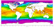
Another reason to root against Atlantic hurricanes this year!Speaking of Blocking and forecasted very low Atlantic Hurricane season to remove the heat out of Atlantic sst's.
Warm Atlantic Sea Surface Temperatures (SSTs) in late summer and fall strongly correlate with increased winter atmospheric blocking, particularly over Greenland and northern Europe. This thermal precursor alters the winter jet stream, favoring high-pressure blocking patterns that typically result in a negative North Atlantic Oscillation (-NAO) configuration. [1, 2]
Key Teleconnection Mechanisms
The delayed, cross-seasonal impact of late summer and fall Atlantic warming on winter circulation operates through several atmospheric and oceanic pathways:
Warm Late-Summer/Fall Atlantic SSTs
│
├─► Reduces Late-Autumn Arctic Sea Ice (Barents/Kara Seas) ──► Weakens Polar Vortex ──► Winter Blocking (-NAO)
│
├─► Triggers Subtropical Atmospheric Rossby Wave Trains ─────► Alters Polar Jet Stream ──► High-Pressure Ridging
│
└─► Ocean Thermal Re-emergence (Subsurface Insulation) ─────► Direct Wint
Currently:
View attachment 197099
if the north atlantic isnt blocked. yes
1997-98 also had a significant winter storm in the SE in late December right after ChristmasBrent,
I don’t know about Tulsa but the strong El Niños of:
-1888-9 (late Feb 1889 major snow)
-1896-7 (early Dec)
-1930-1 (Dec)
-1957-8 (mid-Feb Gulf coast snow incl. New Orleans/SAV)
-1965-6 (Jan esp. in NC)
-1972-3 (Jan historic ZR esp. N GA and Feb historic deep SE snow)
-1982-3 (several snows incl. historic late March)
-1987-8 (big snow and sleet early Jan)
-1991-2 (mid Jan, especially ATL/much of N GA)
-2009-10 (multiple snows esp. Feb storm including at CHS)
all had notable winter storms in the SE. That’s during 10 of the 17 strong El Niños.
1997-98 also had a significant winter storm in the SE in late December right after Christmas
Brent,
I don’t know about Tulsa but the strong El Niños of:
-1888-9 (late Feb 1889 major snow)
-1896-7 (early Dec)
-1930-1 (Dec)
-1957-8 (mid-Feb Gulf coast snow incl. New Orleans/SAV)
-1965-6 (Jan esp. in NC)
-1972-3 (Jan historic ZR esp. N GA and Feb historic deep SE snow)
-1982-3 (several snows incl. historic late March)
-1987-8 (big snow and sleet early Jan)
-1991-2 (mid Jan, especially ATL/much of N GA)
-2009-10 (multiple snows esp. Feb storm including at CHS)
all had notable winter storms in the SE. That’s during 10 of the 17 strong El Niños.
Will the pdo being negative over positive be better in this type of niño or we want the opposite?Well the super strong El Nino like 15-16 and 97-98 is why I'm pessimistic. There was almost zero snow here at all in both years. I was in Dallas in 15-16 and remember zero winter but there was a killer tornado on the day after Christmas! It's true that back in the old days the El Ninos was better and I'm hoping we can return to that but who knows at this point
It also just seems like La Nina has been better here in the last 10-15 years. I know it's been made known how warm last winter was here but we did still have one big storm that made it look like an average winter. Of course the 2 years of La Nina had the two back to back Gulf snowstorms as well
Also the last time we had an El nino a few years ago was when we had the snow holes and it snowed a lot more elsewhere. There's been nothing good about it lately
I mean I hope something changes but that's why I've been so pessimistic
Will the pdo being negative over positive be better in this type of niño or we want the opposite?
Had to delete my post from yesterday. I googled AI strongest El Nino years on record and it gave me the answer for 2 winters that where not the strongest El Nino on record. Which sent me down the wrong road researching climo for GSO for those years.
Don't ask me how that happened, but my apologies.
The strongest two El Nino years on record apparently are
Historically, the 1997–1998 and 2015–2016 events were long regarded as among the most powerful "super" El Niño episodes ever measured. However, rapidly emerging data and multi-model forecasts indicate that the developing 2026–2027 El Niño is on a historic track to potentially become the strongest El Niño on record by a wide


Well the super strong El Nino like 15-16 and 97-98 is why I'm pessimistic. There was almost zero snow here at all in both years. I was in Dallas in 15-16 and remember zero winter but there was a killer tornado on the day after Christmas! It's true that back in the old days the El Ninos was better and I'm hoping we can return to that but who knows at this point
It also just seems like La Nina has been better here in the last 10-15 years. I know it's been made known how warm last winter was here but we did still have one big storm that made it look like an average winter. Of course the 2 years of La Nina had the two back to back Gulf snowstorms as well
Also the last time we had an El nino a few years ago was when we had the snow holes and it snowed a lot more elsewhere. There's been nothing good about it lately
I mean I hope something changes but that's why I've been so pessimistic