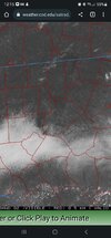
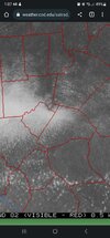
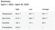
Never got out of the 50s today and got .42” of rain.Yes, we have a wedgie..
-
Hello, please take a minute to check out our awesome content, contributed by the wonderful members of our community. We hope you'll add your own thoughts and opinions by making a free account!
You are using an out of date browser. It may not display this or other websites correctly.
You should upgrade or use an alternative browser.
You should upgrade or use an alternative browser.
Turbulent April '23
- Thread starter Detective WX
- Start date
Shaggy
Member
Perfect rain for the farmers this evening
Twelve years ago right now, who would have thought what the next twenty four hours would bring.
J1C1111
Member
Hung around 54 all day yesterday. Looks to be about the same temp today but with heavier rain. Man, what I would give for a eastern trough to hang around like this during the winter or just half this long. More than 3 days would be nice. Used to happen a good bit in Winters past. 5 springs in a row in my area holding off the real heat till the last week of May. I'll take it every spring like this. Makes the sweltering summers just a tad shorter when they don't start till around Memorial day.
Shaggy
Member
Friday is shaping up to have some potential in parts of the SE for severe
NoSnowATL
Member
I have never witnessed this much rain. Unreal
How about your neighbor shettley? Hes probably out of town and want recollect this time next week.I have never witnessed this much rain. Unreal
Brent
Member
Twelve years ago right now, who would have thought what the next twenty four hours would bring.
Still bothers me to this day when I think about it how so many people died. I mean I knew it was gonna be really bad that night but like I never imagined that bad ever in this day and age with all the warnings
Iceagewhereartthou
Member
Looks like most areas of the upstate have had b/w 3 and 4 inches just today and its still coming down. Plus there was more yesterday and more coming through the weekend.I have never witnessed this much rain. Unreal
Shaggy
Member
MHX hinting at sundays severe setup
By early Sunday a potent and deep upper level trough will spawn
low pressure development across the Deep South. This low will
then move quickly up the Eastern Seaboard later Sunday, and is
likely to deepen rapidly as it moves across NC. This will bring
another period of widespread heavy rain and thunderstorms, as
well as strong winds. A potentially significant severe threat
could develop if instability is sufficient and the current
track of the low, just inland of the forecast area, holds
Shaggy
Member
3k uh tracks through 60hrs

 www.pivotalweather.com

Models: NAM 3km CONUS - Pivotal Weather
View NAM 3km CONUS weather model forecast map image for Updraft Helicity: 0-3 km AGL (run max) in Mid-Atlantic on pivotalweather.com.
BHS1975
Member

Sent from my iPhone using Tapatalk
Why can’t we get severe setups in NC like we did in the 90’s to early 2000’s. Thunderstorms seem rare these days!
The rain is gone and the sun is out here. Wonder if that will spark storms for this afternoon.
NoSnowATL
Member
60% chance.The rain is gone and the sun is out here. Wonder if that will spark storms for this afternoon.
J1C1111
Member
It seems the same thing with winter storms as of late. We used to get them now they seem rare just like severe weather as you said.Why can’t we get severe setups in NC like we did in the 90’s to early 2000’s. Thunderstorms seem rare these days!
Iceagewhereartthou
Member
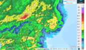
This is from the past 7 days but really most is from the recent rain this week. Boy that upstate bullseye really sticks out; been a few river flooding issues around. Then you have that huge gradient from 6+ down to less than .25 around Calhoun Falls. Looks like most folks got at least an inch or two around the region.

NWS ILM on Severe chances..
Southern stream Gulf Coast States 5H s/w trof will lift toward
the FA late tonight. This as it begins to get pulled into a
rather expansive upper low that it itself is rotating over the
Great Lakes States. Will see moisture from both Gulf of Mexico
and Atlantic drawn into this system, with showers and
thunderstorms spreading northward to the ILM CWA by late this
evening, and eventually encompassing the entire ILM CWA during
the pre-dawn Sun hrs. The convection will have decent
directional and speed shear combined in the lower levels.
Dynamics associated with the approaching upper s/w trof will
compensate the lack of instability (night-time) and should see
some organization that may result in strong to possibly isolated
severe tstorms late tonight, moving onshore. At this point,
Marginal to Slight(Sun) SVR risk what SPC is illustrating looks
on target.
&&&
As for severe threat, it will come down to
instability, but looks like threat of damaging wind gusts will
exist and can`t rule out an isolated tornado with the enhanced
shear in the morning as low moves up from the south. SPC has our
area outlined in a marginal for SC to slight risk for NC zones.
The strongest convection should shift off the coast but
gradient winds will increase. Expect southerly winds up to 25
mph with gusts to 40 possible mainly close to the coast. May see
some redevelopment of storms in the aftn associated with cold
front, but it depends how much instability there is left after
morning convection. Overall, expect an active day of storms with
potential for torrential rain showers and strong gusty winds.
LickWx
Member
I know … it’s happened to me beforeSeriously View attachment 135022
I know … it’s happened to me before
Same here. It's the worst.
On the flip side, there have also been times where I lucked upon the subsidence sucker hole with full sunshine while everyone else around is socked in stratus.
Already over 8" for the month and looks like getting to ready to pile on to that now ??
iGRXY
Member
Creeks, rivers, and streams are wayyyyy up around here. Have gotten 5" through today and the creek behind the house is so far up you can swim in it vs it's usual ankle to chin deep depth. Could use some dry days, but hopefully we keep the below average like the models are showing for the next 10 days.
8.92, still rainingAlready over 8" for the month and looks like getting to ready to pile on to that now ??
Almost doubled my ytd rain this month 6.09 for april8.92, still raining
Max 88.3
Min 33.8
Avg 62.0 +1.3
Rain 6.09 +3
Snow 0
Min 33.8
Avg 62.0 +1.3
Rain 6.09 +3
Snow 0
We still tracking snow? LolMax 88.3
Min 33.8
Avg 62.0 +1.3
Rain 6.09 +3
Snow 0
Pouring again, gonna make a run at 10 inches ?
Max: 89.1
Min: 31.6
Avg: 61.5
Rain: 9.21
Snow: same for last 13 months, zilch
Min: 31.6
Avg: 61.5
Rain: 9.21
Snow: same for last 13 months, zilch
Max: 88.5
Min: 34.7
Avg: 62.4
Rain: 10.44 inches
Lightning: 817 strikes
Min: 34.7
Avg: 62.4
Rain: 10.44 inches
Lightning: 817 strikes


