Sounds pretty normal to me.It would be 10+ below normal.
-
Hello, please take a minute to check out our awesome content, contributed by the wonderful members of our community. We hope you'll add your own thoughts and opinions by making a free account!
You are using an out of date browser. It may not display this or other websites correctly.
You should upgrade or use an alternative browser.
You should upgrade or use an alternative browser.
Turbulent April '23
- Thread starter Detective WX
- Start date
Augusta going to be soft tomorrow
View attachment 040823.mp4
Maybe Nascar gets the heat and truck races in tonight
View attachment 040823.mp4
View attachment 040823.mp4
Maybe Nascar gets the heat and truck races in tonight
View attachment 040823.mp4
2.5” today, midnight high if 51F, afternoon low of 41F.

Finally started raining hard around 4 up to .86
Generally this ended up verifying pretty well.. that bright band ended up being further east but many of these areas still saw 3+ inches of rainfall .. quite an impressive event for many. Will kick droughts ass!
Ron Burgundy
Member
2.61” here. Stayed locked in at 42 pretty much all day. Crazy system. Where was she when we needed her three months ago? ?2.5” today, midnight high if 51F, afternoon low of 41F.
3.74 final tally
3.24” total. The creek has left a mess and I think it took my 300+ pound picnic table which should be fun to find and get out.
BHS1975
Member
Gonna be great for the green up.
Sent from my iPhone using Tapatalk
Sent from my iPhone using Tapatalk
Looks like we may have a frost/light freeze threat middle of next week. GEFS/GEPS/EPS, GFS/Candian/Euro all have a rather stout cold signature around day 9/10 as a deep trough swings through.
2.4 inches in the easternmost Sumter County of South Carolina.
Bannerdude
Member
4.17" in Durham
iGRXY
Member
3.5" here.
Per accurWeather.. Accu,, what ever..
Rare April subtropical storm may brew in Gulf of Mexico this week..
3.73 final total
4.02 inches final tally. My locale is +3.5 over average so far.
Ended up with 4" in Cumberland County just north of Fayetteville, NC
Roxboro made it down to 30 last night and is already down to 37 tonight.
Looks like the Triangle could see some frost tonight, too. My point forecast low is 34. RDU made it down to 36 last night.
Looks like the Triangle could see some frost tonight, too. My point forecast low is 34. RDU made it down to 36 last night.
Brent
Member
We are so gonna pay for this weather. It's too nice 
Downeastnc
Member
So looks like we got the ole rain every weekend pattern setting up, figures since its time to get the garden going etc....
When spring? Right on cue, WCoast ridge! 

accu35
Member
I moved back to Alabama to my old place due to job relocation again.
vsublazer
Member
They are getting hammered right now. Airport shutdown due to flooding.
Drizzle Snizzle
Member
They are getting hammered right now. Airport shutdown due to flooding.
I didn't think their rainy season started until May.
I didn't think they had to be in their rainy season in order to get rain.I didn't think their rainy season started until May.
vsublazer
Member
It’s been a single super cell thunderstorm that has been stationary for several hours now with a few more hours to go. This is just one of those freak weather events.I didn't think their rainy season started until May.
severestorm
Member
vsublazer
Member
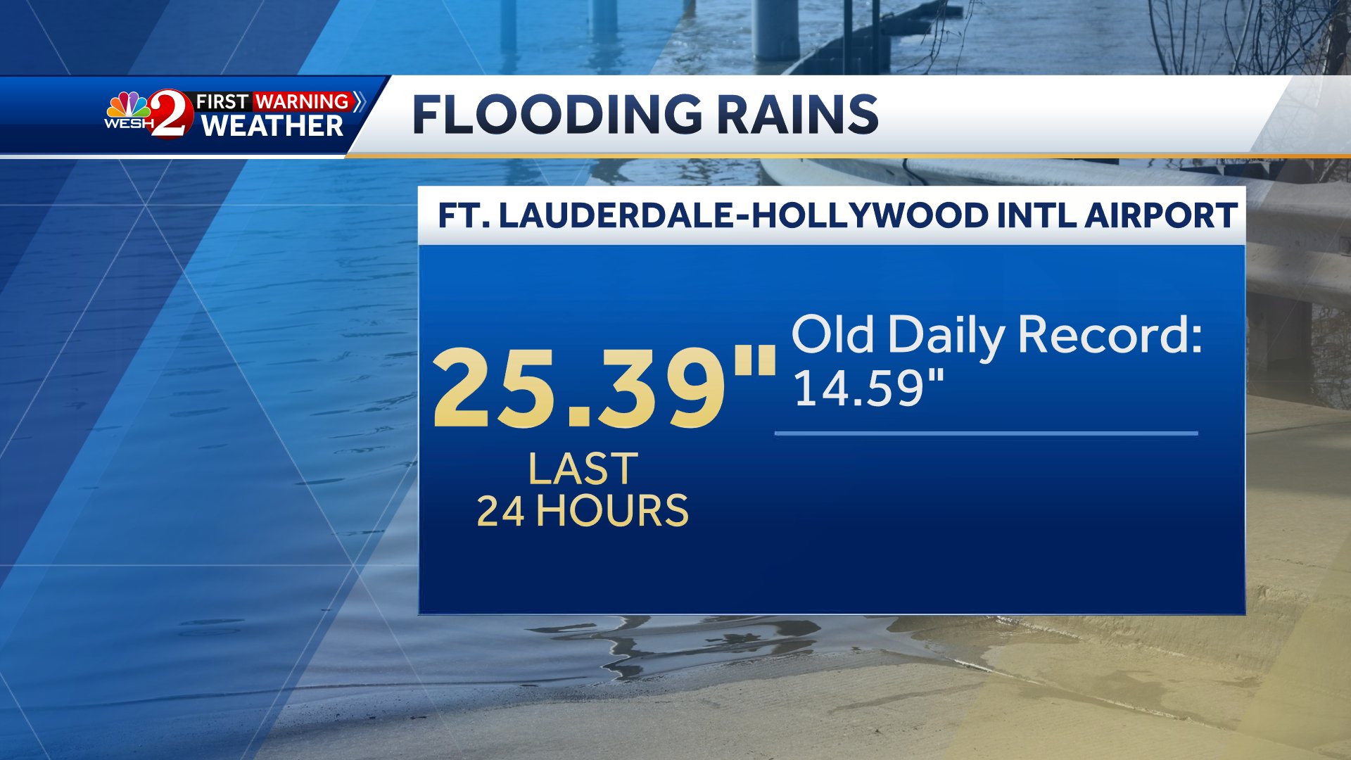
Some perspective of how much rain they have gotten.
I know someone who is down on vacation near Ft Lauderdale now. The flooding looks crazy and those stats are insane. We can’t even get that much snow, and that’s with 10:1 ratios! ?
- Joined
- Jan 23, 2021
- Messages
- 4,603
- Reaction score
- 15,199
- Location
- Lebanon Township, Durham County NC
That almost reminds me of the Columbia flood event
Iceagewhereartthou
Member
I know GFS has been bad but it continues to show some cool fronts coming through to the end of it's run. Of course there are run to run changes but it remains fairly consistent with these. For those of us that like the cooler weather, we may be able to keep the heat at bay, at least through the end of the month. We know the brutal heat will set in eventually.


Forecast called for storms here this morning and another round later this afternoon. All quiet right now.
Had a shower come through this morning. Now the sun is out and it's humid. Wonder if that will be the spark needed for storms this afternoon.
Outrageous rainfall rates right now here in Durham. Feels like I am in Ft Lauderdale. ?
Cary_Snow95
Member
Seemingly caught every storm today here in Cary. Picked up 2.6” of rain. Creeks are like rapids lol
Tornadocane
Member
Some perspective of how much rain they have gotten.
25.39" breaks the 24 hour rainfall record for the entire state of Florida. The former record was 23.28" in Key West during Hurricane Jeane (Nov. 1980).
Public Information Statement
National Weather Service Miami FL
930 AM EDT Thu Apr 13 2023
...PRELIMINARY PRECIPITATION REPORTS FROM THE LAST 24 HOURS...
Fort Lauderdale 25.91 in 0700 AM 04/13 26.08N/80.14W
Hollywood 2.2 SE 18.16 in 0700 AM 04/13 26.01N/80.14W
Dania Beach 17.30 in 0910 AM 04/13 26.07N/80.15W
1 SSE Fort Lauderdale 16.73 in 0904 AM 04/13 26.10N/80.14W
Plantation 3.4 E 15.06 in 0700 AM 04/13 26.12N/80.21W
1 SSE Lauderhill 14.58 in 0909 AM 04/13 26.13N/80.20W
1 SE Lauderdale Lakes 12.60 in 0910 AM 04/13 26.14N/80.19W
National Weather Service
 forecast.weather.gov
Last edited:
Tornadocane
Member
Looks like SE Florida could see another significant rainfall tonight into Monday night. HRRR trending towards stronger thunderstorms reaching the Coastal Broward County.
Looking at the latest hi-res model guidance and the 12Z MFL sounding, there will be potential for a
few strong to severe storms later today. Rich low-level moisture and diurnal heating will lead to plenty of instability in the
atmosphere. Model soundings show increased values of effective shear and MLCAPE this afternoon ,500mb temps will also be around -10 to -11C with modest lapse rates. The stronger storms will be possible mainly over the interior then spreading east to the east coast. Isolated strong to damaging winds and small to marginally severe hail will be possible. Heavy rainfall may lead to localized flooding,especially over areas that are still saturated and still trying to drain from the recent flooding event. While less confidence in tornado potential, there may be a chance for funnel clouds or a brief tornado with any cells that move towards and interact with the Atlantic seabreeze.
forecast.weather.gov

Looking at the latest hi-res model guidance and the 12Z MFL sounding, there will be potential for a
few strong to severe storms later today. Rich low-level moisture and diurnal heating will lead to plenty of instability in the
atmosphere. Model soundings show increased values of effective shear and MLCAPE this afternoon ,500mb temps will also be around -10 to -11C with modest lapse rates. The stronger storms will be possible mainly over the interior then spreading east to the east coast. Isolated strong to damaging winds and small to marginally severe hail will be possible. Heavy rainfall may lead to localized flooding,especially over areas that are still saturated and still trying to drain from the recent flooding event. While less confidence in tornado potential, there may be a chance for funnel clouds or a brief tornado with any cells that move towards and interact with the Atlantic seabreeze.
National Weather Service
forecast.weather.gov
Attachments
Last edited:
Shaggy
Member
Been the least turbulent April IMBY I can remember