-
Hello, please take a minute to check out our awesome content, contributed by the wonderful members of our community. We hope you'll add your own thoughts and opinions by making a free account!
You are using an out of date browser. It may not display this or other websites correctly.
You should upgrade or use an alternative browser.
You should upgrade or use an alternative browser.
Tropical TS Chantal 2025
- Thread starter SD
- Start date
Assuming the flow is correct, Haw at Bynum is pushing 50,000 cubic feet a second, that’s about half what the Guadeloupe was at peak near Kerrville on the morning of 7/4.
BULLETIN - IMMEDIATE BROADCAST REQUESTED
FLOOD WARNING
NATIONAL WEATHER SERVICE RALEIGH NC
1042 PM EDT SUN JUL 6 2025
...FORECAST FLOODING CHANGED FROM MODERATE TO MAJOR SEVERITY AND
INCREASED IN DURATION FOR THE FOLLOWING RIVERS IN NORTH CAROLINA...
HAW RIVER AT HAW RIVER AFFECTING ALAMANCE COUNTY.
250707T1727Z.NO/
1042 PM EDT SUN JUL 6 2025
..FLOOD WARNING NOW IN EFFECT UNTIL EARLY TUESDAY MORNING
* WHAT...MODERATE FLOODING IS OCCURRING AND MAJOR FLOODING IS
FORECAST.
* WHERE...HAW RIVER AT HAW RIVER.
* WHEN...UNTIL EARLY TUESDAY MORNING.
* IMPACTS...AT 18.0 FEET, MINOR FLOODING BEGINS. OVERFLOW BEGINS ON
BOTH BANKS AT THE WATER TREATMENT PLANT.
AT 20.0 FEET, THERE IS SIGNIFICANT OVERFLOW ON THE RIGHT BANK
OPPOSITE THE WATER TREATMENT PLANT. WATER ALSO REACHES THE RED
SLIDE PARK UPSTREAM OF THE MAIN ST. BRIDGE.
AT 23.0 FEET, MODERATE FLOODING BEGINS. FLOODING REACHES THE BASE
OF THE WATER TREATMENT PLANT BUILDING. THERE IS ALSO SIGNIFICANT
FLOODING OF THE RED SLIDE PARK UPSTREAM OF THE MAIN ST. BRIDGE,
AND LANG ST WILL BE IMPASSABLE
AT 25.5 FEET, THE WATER TREATMENT PLANT BUILDING FLOODS.
AT 26.0 FEET, TRAILER HOMES ADJACENT TO THE RIVER AND THE WATER
TREATMENT PLANT FLOOD. EVACUATIONS MAY BE NECESSARY.
AT 27.0 FEET, MAJOR FLOODING BEGINS. THE TOWN OF HAW RIVER BEGINS
TO FLOOD.
AT 28.0 FEET, FLOOD WATERS REACH THE BOTTOM OF THE BRIDGE ACROSS I40.
* ADDITIONAL DETAILS...
- AT 9:45 PM EDT SUNDAY THE STAGE WAS 25.5 FEET.
- FORECAST...THE RIVER IS EXPECTED TO RISE TO A CREST OF 27.5
FEET JUST AFTER MIDNIGHT TONIGHT. IT WILL THEN FALL BELOW
FLOOD STAGE EARLY MONDAY AFTERNOON.
- FLOOD STAGE IS 18.0 FEET.
- FLOOD HISTORY...THIS CREST COMPARES TO A PREVIOUS CREST OF
26.3 FEET ON 09/17/2018.
- HTTP://www.weather.gov/SAFETY/FLOOD
FLD OBSERVED FORECASTS (8 PM EDT)
LOCATION STG STG DAY/TIME MON TUE WED THU
HAW RIVER
HAW RIVE 18.0 25.5 SUN 9 PM EDT 14.0 10.6 8.4 6.0
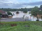
Couple pics sent by friends in SP.


Iceagewhereartthou
Member
Wow guys, crazy. Everbody be safe. Not that I have any pull but praying for you guys in Eastern NC, and poor Texas. Take care everyone.

Not sure if this is left over from all the tears cried this past basketball season, or from the TS that just rolled through.... JK

If this had been snow, I would have been mad to miss out just to the east. But my 3" is perfect compared to the 10"+ just to my west. I do worry about the water rise to Falls Lake. I bet they're releasing the max amount of water at the dam right now. Might run over there later this morning.
Drove home from the Triad (and the mountains earlier in the day) last night. Got back at midnight and it was probably the scariest drive of my life. 40 was completely flooded at one spot, so we got off and tried a side road which had trees down and another completely flooded spot, so we had to turn around along with a ton of other cars. Eventually found 40 again and we must’ve gotten around the currently flooded area, so we were able to take it the rest of the way from there. Insane stuff. I guess driving last night was a bad idea, but it was a busy weekend and I wasn’t paying super close attention to how bad the storm had gotten. 
I can see how dangerous flooding can be at night. It’s hard to see the areas of standing water in the dark.
I can see how dangerous flooding can be at night. It’s hard to see the areas of standing water in the dark.
Last edited:
BrickTamland
Member
80 people have been rescued in Durham.
The sign for Hurricane Fran at the Eno River is under water.

The sign for Hurricane Fran at the Eno River is under water.
BrickTamland
Member
City of Mebane is experiencing water problems due to heavy rainfall.
Here’s a message from City of Mebane:
“Efforts to operate the Mebane water system at a low pressure level will be unable to be maintained as the impacts of Tropical Storm Chantal have impacted Orange-Alamance Water Authority's ability to provide water to the City of Mebane. As a result, the City of Mebane is asking all customers to limit their water usage to zero level for the remainder of today, effective upon this call. An update will be provided at 5 p.m. or beforehand if Orange-Alamance Water Authority can provide additional water or the Graham-Mebane Water Treatment Plant operations can be restored.”
BrickTamland
Member
Hillsborough residents have also been asked to boil and conserve water due to flooding at the water treatment plant.
Heelyes
Member
Same place Fran
BrickTamland
Member
83 year old woman was killed in Chatham County when flood waters swept her away in her car.
good grief did not think a compact moderate strength ts would do this
1 fatal in Chatham county unfortunately.
So, it seems like the last single event for which the bulk of this section of central NC received about this much rain within 24 hours was Fran in 1996 but with perhaps a smaller portion of it getting about this much with Dennis of 1999.
BrickTamland
Member

Anybody know how much roxboro got? Was it over 10”?? Looked really bad on radar last night
Kind of feel like this could’ve been worse locally than those given how fast the rain fell here, although I didn’t live here for Floyd or Florence, to be fair.
There were numerous crazy high 24 hour rainfall amounts in C NC! It’s been over 25 years since widespread very heavy 24 hour rainfall amounts like these occurred in this region:
PUBLIC INFORMATION STATEMENT
NATIONAL WEATHER SERVICE RALEIGH NC
1134 AM EDT MON JUL 7 2025
...24 HOUR PRECIPITATION REPORTS OVER 7 INCHES ENDING AT 8AM FROM
THE REMNANTS OF TROPICAL STORM CHANTAL...
LOCATION AMOUNT TIME/DATE PROVIDER
..NORTH CAROLINA
..ALAMANCE COUNTY
MEBANE 3.0 SSW 9.73 IN 0700 AM 07/07 COCORAHS
BURLINGTON 3.9 NNW 8.01 IN 0700 AM 07/07 COCORAHS
0.5 SW HAW RIVER 7.79 IN 1045 AM 07/07 COOP
1.3 SE GRAHAM 7.62 IN 0705 AM 07/07 COOP
..CHATHAM COUNTY
2.4 N MONCURE 11.92 IN 1045 AM 07/07 COOP
PITTSBORO 8.8 NNE 11.53 IN 0700 AM 07/07 COCORAHS
PITTSBORO 5.0 NE 10.37 IN 0700 AM 07/07 COCORAHS
PITTSBORO 3.3 NNW 10.35 IN 0849 AM 07/07 COCORAHS
PITTSBORO 10.15 IN 1055 AM 07/07 CWOP
CHAPEL HILL 5.9 SW 10.05 IN 0700 AM 07/07 COCORAHS
PITTSBORO 5.4 WSW 9.44 IN 0700 AM 07/07 COCORAHS
CHAPEL HILL 8.6 SSW 9.25 IN 0700 AM 07/07 COCORAHS
PITTSBORO 0.8 NNW 9.12 IN 0700 AM 07/07 COCORAHS
SILER CITY 6.6 ENE 9.10 IN 0640 AM 07/07 COCORAHS
SILER CITY 8.1 ENE 8.14 IN 0800 AM 07/07 COCORAHS
GOLDSTON 3.8 N 7.94 IN 0700 AM 07/07 COCORAHS
SILER CITY 7.2 NE 7.54 IN 0800 AM 07/07 COCORAHS
SILER CITY 7.23 IN 1055 AM 07/07 CWOP
SILER CITY 7.10 IN 0700 AM 07/07 COCORAHS
..DURHAM COUNTY
DURHAM 4.6 WNW 8.46 IN 0700 AM 07/07 COCORAHS
DURHAM 5.8 NW 8.23 IN 0700 AM 07/07 COCORAHS
HILLSBOROUGH 7.26 IN 1100 AM 07/07 CWOP
DURHAM 5.2 NW 7.19 IN 0615 AM 07/07 COCORAHS
..MOORE COUNTY
2 WSW WHISPERING PINES 7.45 IN 0800 AM 07/07 COCORAHS
WHISPERING PINES 1.0 SW 7.20 IN 0800 AM 07/07 COCORAHS
..ORANGE COUNTY
HILLSBOROUGH 8.4 NNE 10.49 IN 0840 AM 07/07 COCORAHS
HILLSBOROUGH 7.4 NW 10.43 IN 0700 AM 07/07 COCORAHS
CHAPEL HILL 4.5 WSW 10.22 IN 0700 AM 07/07 COCORAHS
HILLSBOROUGH 5.6 NNW 9.96 IN 0700 AM 07/07 COCORAHS
CARRBORO 0.7 NNE 9.82 IN 0800 AM 07/07 COCORAHS
DURHAM 6.7 WNW 9.80 IN 0800 AM 07/07 COCORAHS
CHAPEL HILL 4.7 SW 9.57 IN 0700 AM 07/07 COCORAHS
DUKE FOREST DURHAM 11 W 9.36 IN 1100 AM 07/07 HADS
DURHAM 9.28 IN 1045 AM 07/07 CWOP
CHAPEL HILL 2.0 NNE 9.20 IN 0700 AM 07/07 COCORAHS
EFLAND 4.0 NNW 9.10 IN 0700 AM 07/07 COCORAHS
HILLSBOROUGH 0.6 NNW 8.89 IN 0800 AM 07/07 COCORAHS
EFLAND 8.75 IN 1055 AM 07/07 CWOP
CHAPEL HILL 4.3 WSW 8.70 IN 0730 AM 07/07 COCORAHS
HILLSBOROUGH 1.8 S 8.41 IN 0800 AM 07/07 COCORAHS
CARRBORO 0.8 SE 8.36 IN 0700 AM 07/07 COCORAHS
HILLSBOROUGH 1.5 NE 8.36 IN 0700 AM 07/07 COCORAHS
CARRBORO 0.6 NNE 8.32 IN 0602 AM 07/07 COCORAHS
0.5 SE CARRBORO 8.00 IN 0700 AM 07/07 COOP
CHAPEL HILL 8.2 W 7.92 IN 0700 AM 07/07 COCORAHS
CHAPEL HILL 7.88 IN 1229 AM 07/07 CWOP
DUKE FOREST MET STA NR CHAPE 7.82 IN 1016 AM 07/07 RAWS
CHAPEL HILL 7.2 WSW 7.76 IN 0800 AM 07/07 COCORAHS
CHAPEL HILL 4.0 WNW 7.73 IN 0700 AM 07/07 COCORAHS
CHAPEL HILL 9.4 W 7.69 IN 0730 AM 07/07 COCORAHS
HURDLE MILLS 7.58 IN 1045 AM 07/07 CWOP
ROUGEMONT 4.7 SW 7.54 IN 0700 AM 07/07 COCORAHS
CHAPEL HILL 11.4 W 7.53 IN 0715 AM 07/07 COCORAHS
HILLSBOROUGH 4.0 SSW 7.48 IN 0600 AM 07/07 COCORAHS
1 SE CHAPEL HILL 7.33 IN 0700 AM 07/07 COCORAHS
HILLSBOROUGH 2.8 SSW 7.27 IN 0709 AM 07/07 COCORAHS
2 NNE CHAPEL HILL 7.21 IN 1105 AM 07/07 AWS
..PERSON COUNTY
HURDLE MILLS 5.2 NNW 9.15 IN 0800 AM 07/07 COCORAHS
Last edited:
See? I told ya this was going to be a repeat of PTC 8 (Helene A)!
I rest my case. Helene A dumped over 20" of rain in Southport. Now Chantal beat Helene A!Please don't let this be another Helene A (PTC 8)