No way I'm falling for this. Next run will have it over Winston. Kind of joking, but the Nam always does this stuff. I mean 0z last night had us in the crosshairs for big rain today. It's a really terrible model beyond about 3-6 hours.
-
Hello, please take a minute to check out our awesome content, contributed by the wonderful members of our community. We hope you'll add your own thoughts and opinions by making a free account!
You are using an out of date browser. It may not display this or other websites correctly.
You should upgrade or use an alternative browser.
You should upgrade or use an alternative browser.
Tropical TS Bertha
- Thread starter Snowfan
- Start date
Tornado warning for me right now.

Did you win?Tornado warning for me right now.
That one looked to be around a EF -5. Wind gusted to 3mph. A new, more vigorous cell is moving in now. Heavy rain but no wind so far. This one isn't warned right now.Did you win?
B
Brick Tamland
Guest
Tornado warning for me right now.
Weird seeing it move from SE to NW.
And guess what? Severe weather without a watch again
Weird seeing it move from SE to NW.
And guess what? Severe weather without a watch again
NWS isn't going to issue a watch because of one warned cell...
This is a very marginal risk, at best.
It is flat out pouring.
B
Brick Tamland
Guest
NWS isn't going to issue a watch because of one warned cell...
This is a very marginal risk, at best.
That isn't my point. My point is we have more severe storms around my area the past few years when we don't have a watch versus when we do.
B
Brick Tamland
Guest
All the local news stations are doing their regular newscast. Must not be too worried about the tornado warning.
Yeah, it absolutely poured buckets for about 2 1/2 hours here in Wingate. The creek at the bottom of the hill is going over the road. I’ve 1.9 “ in the gauge since midnight...17.3” mtdHeaviest, steadiest rain so far over my area, has been pouring for about 2 hours. Surprised there are no flood advisories out.
That isn't my point. My point is we have more severe storms around my area the past few years when we don't have a watch versus when we do.
There have been numerous watches that have been issued this winter/spring. Unless you are talking about an organized event, you can't expect a watch every time there is a warning issued. That's very typical especially as we enter the summer months.
Track cone shifted west again could ride i77...placing Raleigh to Greensboro area in the right quad for a tornado warning or two.
Avalanche
Member
Rain, at least here in my part of Chatham, has been very light & misty. Radar returns look much more robust than what's falling. Is that the case everywhere in NC under the dark greens/oranges/reds?
Heavy wind blown rain. Sheets of rain blowing off the roofs.
B
Brick Tamland
Guest
There have been numerous watches that have been issued this winter/spring. Unless you are talking about an organized event, you can't expect a watch every time there is a warning issued. That's very typical especially as we enter the summer months.
Again, you are not getting my point.
B
Brick Tamland
Guest
A tornado touched down in Warren County.

 www.wral.com
Surveyors: EF-0 Tornado touched down in Warren Co., 85mph winds
Tropical Storm Bertha made landfall east of Charleston, South Carolina, at 9:30 a.m. and will bring rain to North Carolina Wednesday and Thursday.
www.wral.com
Flooding
Raleigh area to the OBX looks interesting late tonight per models. Everyone sleeping with storms.
Storms ongoing tomorrow morning, almost like Bertha forms a tail. 
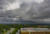
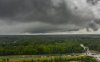
Here are a few aerials I took as a few mini supercells rotated through with one of Bertha's bands in southern Wake. Of course one of them prompted a warning. I didn't see any visible funnels but interesting none the less:
Attachments

At least we got a little something. Remember that NAM run yesterday that had the 3" feeder band training over us? Where the heck is that bad boy?
63 miles eastAt least we got a little something. Remember that NAM run yesterday that had the 3" feeder band training over us? Where the heck is that bad boy?