• Hello, please take a minute to check out our awesome content, contributed by the wonderful members of our community. We hope you'll add your own thoughts and opinions by making a free account!

Tropical Tropical Storm Beryl 2024

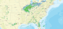
Texarkana is on the map to get a Tropical Storm. A depression over the Great Lakes and Ontario.

091729_5day_cone_no_line_and_wind.png


Posting the following for emphasis.

091729_current_wind_sm.png
 
Overall it's thinning out, but not in the center. Scroll up to the solid red circle over the northwest Houston metro.
 
800 AM CDT Mon Jul 8 2024

...LIFE-THREATENING STORM SURGE, DAMAGING WINDS AND FLOODING
RAINFALL CONTINUE ACROSS PORTIONS OF EASTERN TEXAS...
...800 AM CDT POSITION UPDATE...

A mesonet station (FRPT2) in Freeport recently reported a wind gust
of 94 mph (151 km/h).

A National Ocean Service (NOS) station (GNJT2) at the entrance to
Galveston Bay recently measured a sustained wind of 73 mph (117
km/h) and a gust of 82 mph (131 km/h).

A USGS gauge at Galveston Railroad Bridge recently reported an
inundation of 3.6 ft above Mean Higher High Water (MHHW).

SUMMARY OF 800 AM CDT...1300 UTC...INFORMATION
-----------------------------------------------
LOCATION...29.4N 95.8W
ABOUT 30 MI...50 KM SW OF HOUSTON TEXAS
MAXIMUM SUSTAINED WINDS...75 MPH...120 KM/H
PRESENT MOVEMENT...N OR 10 DEGREES AT 12 MPH...19 KM/H
MINIMUM CENTRAL PRESSURE...980 MB...28.94 INCHES
 
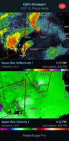
TORNADO WARNING FOR...
SOUTHWESTERN TYLER COUNTY IN SOUTHEASTERN TEXAS...
WESTERN HARDIN COUNTY IN SOUTHEASTERN TEXAS...


* TORNADO WARNING FOR...
NORTHEASTERN GALVESTON COUNTY IN SOUTHEASTERN TEXAS...
SOUTHEASTERN CHAMBERS COUNTY IN SOUTHEASTERN TEXAS...

* UNTIL 800 AM CDT.

* AT 748 AM CDT, SEVERE THUNDERSTORMS CAPABLE OF PRODUCING A TORNADO
WAS LOCATED OVER ROLLOVER PASS, OR 21 MILES NORTHEAST OF GALVESTON
PIER 21, MOVING NORTH AT 60 MPH.

 
Hurricane Beryl Tropical Cyclone Update
NWS National Hurricane Center Miami FL AL022024
900 AM CDT Mon Jul 8 2024

...DAMAGING WINDS AND FLOODING RAINFALL CONTINUE ACROSS PORTIONS
OF SOUTHEAST TEXAS INCLUDING THE HOUSTON AREA...
...900 AM CDT POSITION UPDATE...

Houston Hobby Airport (KHOU) recently reported a sustained wind of
58 mph (93 km/h) and a gust of 84 mph (135 km/h).

A National Ocean Service (NOS) station at Morgans Point recently
measured a sustained wind of 66 mph (106 km/h) and a gust to 77 mph
(124 km/h).

SUMMARY OF 900 AM CDT...1400 UTC...INFORMATION
-----------------------------------------------
LOCATION...29.7N 95.7W
ABOUT 20 MI...30 KM W OF HOUSTON TEXAS
MAXIMUM SUSTAINED WINDS...75 MPH...120 KM/H
PRESENT MOVEMENT...N OR 10 DEGREES AT 12 MPH...19 KM/H
MINIMUM CENTRAL PRESSURE...981 MB...28.97 INCHES

$$
Forecaster Hagen/Blake
 
Impressive for a cat1


Beryl is a great example of the idea that a strengthening cat 1 (and low end at that) often has worse effects than a weakening cat 2. Nothing against the Saffir Simpson Scale, but it is often deceptive as regards total impact. The Joe Bastardi “Power/Impact Scale” is a good idea because it better measures total impact imo. Also, the IKE scale is often a better indicator of storm surge. Coincidentally, Hurricane Ike hit TX as a cat 2 but had larger impacts than the avg cat 2.
 
Houston is an hour inland and still gusting over 80 mph

Indeed, here are the 10AM CDT conditions:

HOUSTON BUSH HVY RAIN 74 73 97 SE55G82 29.25F VSB 1/4 TC 23

HOUSTON HOBBY LGT RAIN N/A N/A N/A S48G75 29.37R
 
Relentlessly continues in Houston:

Tropical Storm Beryl Tropical Cyclone Update...Corrected
NWS National Hurricane Center Miami FL AL022024
1100 AM CDT Mon Jul 8 2024

Corrected Header

...LIFE-THREATENING STORM SURGE, DAMAGING WIND GUSTS, AND
FLOODING RAINFALL CONTINUING OVER EASTERN TEXAS...
...1100 AM CDT POSITION UPDATE...

Houston Bush Intercontinental Airport (KIAH) recently reported a
sustained wind of 59 mph (95 km/h) with a gust to 82 mph (132 km/h).

SUMMARY OF 1100 AM CDT...1600 UTC...INFORMATION
-----------------------------------------------
LOCATION...30.1N 95.6W
ABOUT 30 MI...50 KM NNW OF HOUSTON TEXAS
MAXIMUM SUSTAINED WINDS...70 MPH...110 KM/H
PRESENT MOVEMENT...NNE OR 15 DEGREES AT 13 MPH...20 KM/H
MINIMUM CENTRAL PRESSURE...984 MB...29.06 INCHES

$$
Forecaster Hagen/Blake
 
1200 PM CDT Mon Jul 8 2024

...LIFE-THREATENING STORM SURGE, DAMAGING WIND GUSTS, AND
FLOODING RAINFALL PERSISTING OVER EASTERN TEXAS...
...1200 PM CDT POSITION UPDATE...

Montgomery County Airport in Conroe (KCXO) recently reported a wind
gust to 81 mph (130 km/h).

This is the last hourly position estimate for Beryl. The next
information will be the regularly scheduled 1 PM CDT Intermediate
advisory.


SUMMARY OF 1200 PM CDT...1700 UTC...INFORMATION
-----------------------------------------------
LOCATION...30.3N 95.6W
ABOUT 45 MI...70 KM NNW OF HOUSTON TEXAS
MAXIMUM SUSTAINED WINDS...65 MPH...100 KM/H
PRESENT MOVEMENT...NNE OR 15 DEGREES AT 13 MPH...20 KM/H
MINIMUM CENTRAL PRESSURE...986 MB...29.12 INCHES
 
BULLETIN
Tropical Storm Beryl Intermediate Advisory Number 40A
NWS National Hurricane Center Miami FL AL022024
100 PM CDT Mon Jul 08 2024

...FLASH FLOODING AND GUSTY WINDS CONTINUING OVER EASTERN TEXAS...
...USE CAUTION AFTER THE STORM AS DEADLY HAZARDS REMAIN INCLUDING
DOWNED POWERLINES AND CARBON MONOXIDE POISONING FROM IMPROPER
GENERATOR USE...


SUMMARY OF 100 PM CDT...1800 UTC...INFORMATION
----------------------------------------------
LOCATION...30.5N 95.5W
ABOUT 55 MI...90 KM N OF HOUSTON TEXAS
MAXIMUM SUSTAINED WINDS...60 MPH...95 KM/H
PRESENT MOVEMENT...NNE OR 15 DEGREES AT 14 MPH...22 KM/H
MINIMUM CENTRAL PRESSURE...987 MB...29.15 INCHES


A National Ocean Service station
near the entrance to Galveston Bay (GNJT2) recently reported
sustained winds of 46 mph (74 km/h), and a wind gust of 58 mph (93
km/h). Huntsville Municipal Airport (KUTS) in Texas measured a
wind gust of 56 mph (90 km/h), and Beaumont/Port Arthur Regional
Airport (KBPT) recently reported a wind gust of 54 mph (87 km/h).
 
Last edited:
Back
Top