-
Hello, please take a minute to check out our awesome content, contributed by the wonderful members of our community. We hope you'll add your own thoughts and opinions by making a free account!
You are using an out of date browser. It may not display this or other websites correctly.
You should upgrade or use an alternative browser.
You should upgrade or use an alternative browser.
Tropical Tropical Storm Beryl 2024
- Thread starter SD
- Start date
Belle Lechat
Member
- Joined
- Aug 29, 2021
- Messages
- 1,100
- Reaction score
- 847
The recon planes, top of this page, didn't go to Beryl.
Henry2326
Member
Belle Lechat
Member
- Joined
- Aug 29, 2021
- Messages
- 1,100
- Reaction score
- 847
Last edited:
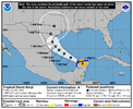
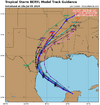
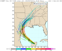
They will need to shift north 30-40 miles again on the 5pm track update here shortlyQuite a shift North.
Brent
Member
Not gonna be over the Yucatan nearly as long as forecast
The track is gonna shift more NE
The track is gonna shift more NE
This is the most stubborn storm ever.Not gonna be over the Yucatan nearly as long as forecast
The track is gonna shift more NE
Belle Lechat
Member
- Joined
- Aug 29, 2021
- Messages
- 1,100
- Reaction score
- 847
If the recon planes won't go to Beryl, Beryl will go to the recon planes?
EDIT Well look what just updated.

EDIT Well look what just updated.

Brick Tamland
Member
Wonder if it will blow up once it is back in the Gulf like we have seen with other storms the past few years.
Models indicate it will struggle with dry air for about a day and then on Sunday, intensify.Wonder if it will blow up once it is back in the Gulf like we have seen with other storms the past few years.
Brent
Member
Belle Lechat
Member
- Joined
- Aug 29, 2021
- Messages
- 1,100
- Reaction score
- 847
That light northern arm of Beryl is coming up on the storm arc in the southeast US.


Brick Tamland
Member
Just wonder how much it will intensify. We have seen them go from a cat 1 to cat 3 overnight the past few years.Models indicate it will struggle with dry air for about a day and then on Sunday, intensify.
The small hope I have is that Beryl struggles to re-intensify off of the Yucatan like the struggle of Isidore of 2002. Any thoughts? I remember this well. It was very large (see image below), which probably was a negating factor. Beryl is much smaller. Thus, my hope for a slow re-intensification like for Isidore is limited:
"The inner core of convection collapsed while over southeast Mexico, and upon moving northward and reaching the Gulf of Mexico again, it was a large but weak tropical storm. Conditions favored significant strengthening, but Isidore did not redevelop central convection until reaching the northern Gulf of Mexico. The strengthening system hit Grand Isle, Louisiana on September 26 with maximum sustained winds of 65 mph (105 km/h)"

 en.wikipedia.org
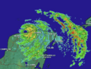
"The inner core of convection collapsed while over southeast Mexico, and upon moving northward and reaching the Gulf of Mexico again, it was a large but weak tropical storm. Conditions favored significant strengthening, but Isidore did not redevelop central convection until reaching the northern Gulf of Mexico. The strengthening system hit Grand Isle, Louisiana on September 26 with maximum sustained winds of 65 mph (105 km/h)"

Hurricane Isidore - Wikipedia

WATCHES AND WARNINGS
--------------------
CHANGES WITH THIS ADVISORY:
A Hurricane Watch is now in effect for the Texas coast from the
mouth of the Rio Grande northward to Sargent.
A Storm Surge Watch is now in effect for the Texas coast from the
mouth of the Rio Grande northward to Sargent.
The Meteorological Service of Mexico has issued a Hurricane Watch
for the northeastern coast of Mexico from Barra el Mezquital to
the mouth of the Rio Grande.
Belle Lechat
Member
- Joined
- Aug 29, 2021
- Messages
- 1,100
- Reaction score
- 847
4:00 PM CDT Fri Jul 5
Location: 21.2°N 89.2°W
Moving: WNW at 15 mph
Min pressure: 989 mb
Max sustained: 65 mph
Location: 21.2°N 89.2°W
Moving: WNW at 15 mph
Min pressure: 989 mb
Max sustained: 65 mph
Brent
Member
The new
intensity forecast now calls for an 80-kt intensity at landfall in
best agreement with the HWRF, HAFS-B, and HMON models, and this
could be conservative if Beryl stays over water longer than
currently forecast.
intensity forecast now calls for an 80-kt intensity at landfall in
best agreement with the HWRF, HAFS-B, and HMON models, and this
could be conservative if Beryl stays over water longer than
currently forecast.

