Brent
Member
Thread title in shambles View attachment 174641
Yeah fake fall is on fire this year here
We're gonna go a week without getting above 81. As im typing this there is more rain and clouds moving in lol
Leading into September...
Thread title in shambles View attachment 174641
I want in real warm all the way until mid December and then go into the icebox for most if not all winterYeah fake fall is on fire this year here
We're gonna go a week without getting above 81. As im typing this there is more rain and clouds moving in lol
Leading into September...
I want in real warm all the way until mid December and then go into the icebox for most if not all winter
It does not take a very cold winter to get snow. We have no need to ever get below 25 degrees at all.I want in real warm all the way until mid December and then go into the icebox for most if not all winter
We will get the usual 3 to 5 days of artic airmass early january , after that winter will be warmer than average for the rest of itI want in real warm all the way until mid December and then go into the icebox for most if not all winter
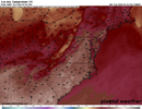
12z GFS and euro does show it getting hot (especially for Saturday). But the front (on both models) still goes through later on Sunday. Just delayed....So much for the big cool down that was coming. From WRAL's Chris Michaels.
I'm monitoring a trend in the forecast data regarding next weekend.
Yesterday and the day prior, data were all excited about a strong cold front moving through. In recent runs, it doesn't show the cold front swinging through. Rather, it shows all the upper-level wind focused around the Great Lakes/Upper Midwest, keeping the cold front from us.
IF this comes to fruition, it might actually get a little toasty Friday and Saturday and a BIG cool-down wouldn't materialize.
We'll keep an eye on it.
Mid 90s in parts of Georgia next weekend. A couple days ago it was supposed to be unusually cold next weekend. Glenn Burns was going crazy on Facebook talking about how cold it was gonna be !Yeah, looks like a heat wave next weekend. I’m not sure how the models are that bad within that range. Pretty embarrassing though.
Mid 90s in parts of Georgia next weekend. A couple days ago it was supposed to be unusually cold next weekend. Glenn Burns was going crazy on Facebook talking about how cold it was gonna be !
The GFS in typical hot bias form has highs of 98-100 down here next weekend. The other models are still hot with low to mid 90s, but they’re much more believable.
This weather is such a tease. Perfect weather with low humidity. I’m not looking forward to temps in the low to mid 90s on Fri and Sat.

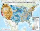
I just saw this showing summer 2025 precip: note how wet Brent and Mack were as well as much if TX. Also, significant parts of GA/SC/NC were quite wet. I can vouch for the very wet SAV area, which appears to at least be within the top 10 in much of the area. I see green (wettest of last 131 summers) ~50 miles W of GeorgiaGirl and between RDU and GSO, where Chantal hit so hard:
View attachment 174669
Cold April never disappoints. I should downgrade the server too no need for the extra space to read, oof, womp, SER, torch and so onWhat with Shetley's prediction of a desert fall and Eric's canceling winter, we might as well turn out the lights until next year.

| Humidity | 100% |
| Wind Speed | Calm |
| Barometer | 30.12 in |
| Dewpoint | 50°F (10°C) |
| Visibility | 1.75 mi |
| Last update | 2 Sep 6:15 am EDT |


It's been about two weeks since we have had any significant rainfall and it looks like something tropical is our best bet for the foreseeable future. The below normal temperatures have been a blessing, if we had normal or above normal temperatures to deal with, the heat stress on the plant life from this dry spell would be worse.If TD12 recurves thats our best chance of rain in weeks and that's kind of sad
Looks like the heatwave will be brief but this potential strong positive heights across Canada pattern isn't that exciting.
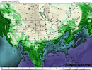
Tropical system ?That big heatwave on the long range GFS has been gone for 2 runs now and hopefully it stays gone. The last 2 runs have also been wetter.
It’s at the range were the gfs loose a solution then eventually brings it back two three days later. Time will tellThat big heatwave on the long range GFS has been gone for 2 runs now and hopefully it stays gone. The last 2 runs have also been wetter.
No.Tropical system ?
