-
Hello, please take a minute to check out our awesome content, contributed by the wonderful members of our community. We hope you'll add your own thoughts and opinions by making a free account!
You are using an out of date browser. It may not display this or other websites correctly.
You should upgrade or use an alternative browser.
You should upgrade or use an alternative browser.
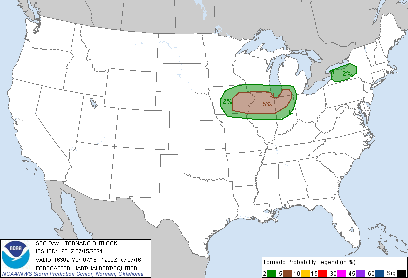
Severe Severe Weather Threat 1/1/17-1/2/17
- Thread starter Laucked
- Start date

T
Thundersnow89
Guest
Just looked at the radar....wow impressed with all the lightning down that way
Sent from my SM-G928V using Tapatalk
Sent from my SM-G928V using Tapatalk
T
Thundersnow89
Guest
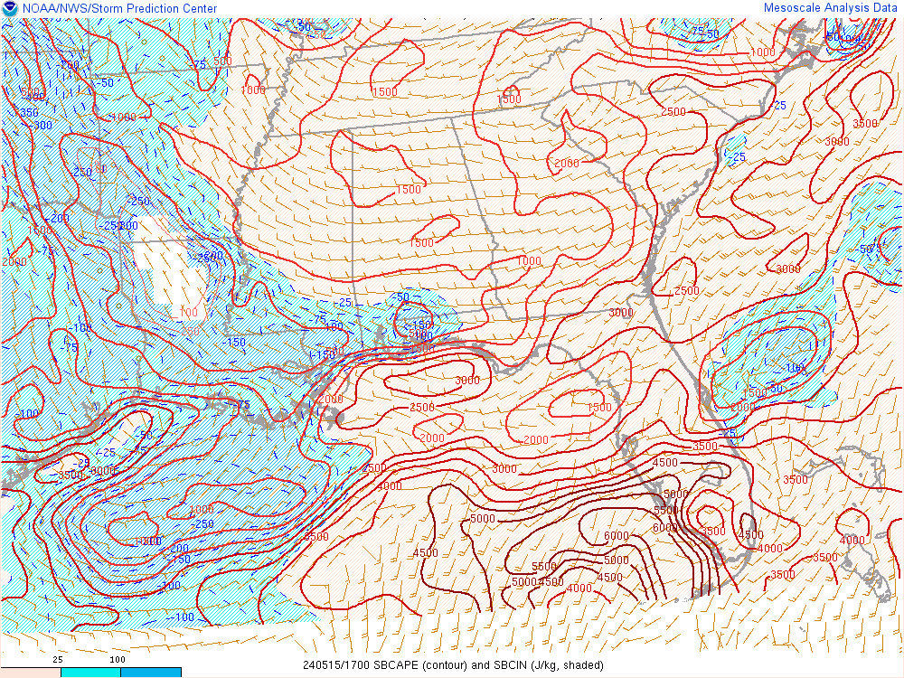
That's some pretty stout instability down south
accu35
Member
Tornado here
accu35
Member
Pics?SD link said:[quote author=accu35 link=topic=84.msg7252#msg7252 date=1483381577]
Tornado here
Sent from my SM-G928V using Tapatalk
[/quote] well I couldn't because I was watching my kids in the hall way, but everything is thrown around and our American flag is torn in two. Winds are bad, large hail
Pics?SD link said:[quote author=accu35 link=topic=84.msg7252#msg7252 date=1483381577]
Tornado here
Sent from my SM-G928V using Tapatalk
[/quote]Are you in South West Al. ?
accu35
Member
Pics?sigwx link said:[quote author=SD link=topic=84.msg7283#msg7283 date=1483382681]
[quote author=accu35 link=topic=84.msg7252#msg7252 date=1483381577]
Tornado here
Sent from my SM-G928V using Tapatalk
[/quote]Are you in South West Al. ?
[/quote]yes
accu35
Member
It has literally rain for 3 days now, flooded
T
Thundersnow89
Guest
Starting to believe BMX had the right idea all along. North Alabama has been in torrential rain all morning, warm front is still way too the south. Could things change? Of course and I still wouldn't rule out a warning or two as far north as I-20. Southern portions of Louisiana Mississippi and Alabama as well as the Florida Panhandle should remain alert for a high impact event. That area is an absolute powder keg right now.
I was just looking at the dew pts. down their, lower 70's. As you said she's ready blow.
WeatherDawg87
Member
Laurens County in Central Georgia is currently a tornado warning.
accu35
Member
Our local roads are closed due to the rain, flooded bad
accu35
Member
Sorry Shane for not posting pic, I'm stuck at the house
Lol no worries. I was just being funnyaccu35 link said:Sorry Shane for not posting pic, I'm stuck at the house
Sent from my SM-G928V using Tapatalk
I think all this rain is going to change our Severe Threat in C. Al.
sigwx link said:I think all this rain is going to change our Severe Threat in C. Al.
Beginning to look that way...
MichelleH link said:[quote author=sigwx link=topic=84.msg7362#msg7362 date=1483385891]
I think all this rain is going to change our Severe Threat in C. Al.
Beginning to look that way...
[/quote]I just check my rain bucket and l measured .85 in the last 45 mins. and it is still pouring
Bama Ravens
Member
Well, looks like BMX is of the belief that the rain has worked over the atmosphere, and the threat is confined to the SE portion of their CWA.
accu35
Member
ATM we received over 4 in of rain just from today, WOW!!!
accu35
Member
These thunderstorms are amazing today, dangerous but amazing
Quite a few couplets on radar right now
Sent from my SM-G928V using Tapatalk
Sent from my SM-G928V using Tapatalk
WeatherDawg87
Member
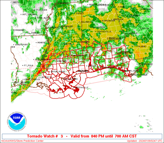
New tornado watch out that covers the FL Panhandle and most of SW GA.
Ron Burgundy
Member
Where are you?accu35 link said:ATM we received over 4 in of rain just from today, WOW!!!
accu35
Member
OMG round two, this is insane
accu35
Member
Where are you?Ron Burgundy link said:[quote author=accu35 link=topic=84.msg7388#msg7388 date=1483387205]
ATM we received over 4 in of rain just from today, WOW!!!
[/quote]Jackson AL
accu35
Member
I have never seen such a energetic storms as these
Ron Burgundy
Member
SD link said:Quite a few couplets on radar right now
Sent from my SM-G928V using Tapatalk
The one southwest of Auburn looks bad even to my untrained eye.
EDIT: on the ground now.

gawxnative
Member
Looking at a trio of them from Ft Rucker Nexrad.... Can t get them to post though!!

Sent from my SM-G928V using Tapatalk
Drought killer here, I'm at over five and a quarter since New Years Eve with tons of heavy precip to come. And I have a leak in the roof, great.
You have had a lot of rain in Coosa County, l have had 4.4" so far since 12/31/16. this is going to help all the area ponds and river systems and your correct a lot more to come tonight.ARCC link said:Drought killer here, I'm at over five and a quarter since New Years Eve with tons of heavy precip to come. And I have a leak in the roof, great.
WeatherDawg87
Member
sigwx said:You have had a lot of rain in Coosa County, l have had 4.4" so far since 12/31/16. this is going to help all the area ponds and river systems and your correct a lot more to come tonight.ARCC link said:Drought killer here, I'm at over five and a quarter since New Years Eve with tons of heavy precip to come. And I have a leak in the roof, great.
Confirmed tornado on the ground near Dothan, AL.
WeatherDawg87
Member
The tornado warned storm around Dothan looks nasty!
Brent
Member
Southeast of Dothan
Four people were killed by a tornado that tore through southern Houston County Monday night.
Gov. Robert Bentley’s office has confirmed four deaths, which occurred in the Rehobeth area.
Four people were killed by a tornado that tore through southern Houston County Monday night.
Gov. Robert Bentley’s office has confirmed four deaths, which occurred in the Rehobeth area.
What's with the random wind advisory in Ga? Wind is barely blowing and it's only valid for a few hours?? 
Sent from my iPhone using Tapatalk

Sent from my iPhone using Tapatalk