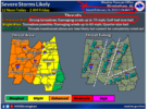
bmx graphic
 Area Forecast Discussion
National Weather Service Birmingham AL
255 AM CST Thu Feb 16 2023
...New SHORT TERM, LONG TERM...
.SHORT TERM...
(Today through Friday)
Issued at 255 AM CST THU FEB 16 2023
Through Tonight.
//Severe storms
likely today and tonight//
After 7 days of advertising today`s severe threat, now it`s go time
to put your preparations and severe weather plan into practice. An
upper low over western Kansas will move northeastward and
shear out
as it moves into Iowa later today, as its associated southern stream
trough phases with the northern stream. This positively tilted
trough will extend southwestward from Wisconsin to New Mexico by
this afternoon. A broad swath of 50 to 60kt southwesterly mid-level
flow will extend well ahead of this
trough over a moist and unstable
warm sector, with various weak subtropical perturbations evident in
water vapor imagery extending southwestward back to Mexico. A
surface low has developed along a frontal boundary over northwest
Arkansas, and will remain fairly steady state as it lifts
northeastward today, before beginning to deepen over the Ohio Valley
tonight. The associated cold
front will reach eastern Mississippi
late this afternoon and move through Alabama tonight.
The 6z special
sounding from Jackson MS in support of PERiLS
indicates an impressive elevated
mixed layer with a 700-500mb lapse
rate of 8
C/km as well as a strong
cap. This
cap should hold
overnight south of northern Mississippi and will remove the
overnight marginal risk for our northwest counties. Despite the lack
of greater synoptic forcing, models including CAMs are consistent in
a weak
impulse in southwest
flow aloft breaking the
cap and
initiating supercells across central and southern Mississippi late
this morning, then moving northeastward into our southwest counties
early this afternoon. These discrete to semi-discrete supercells
will then continue northeastward across the forecast area through
the afternoon hours with additional development occurring along the
cold
front over Mississippi and in between.
You don`t often see the
number of identifiable supercells apparent in CAM output in this
area that recent runs have shown. A moist (PWATs around 1.75") and
volatile air mass will be in place especially along and west of I-65
with SBCAPE values of 1000 to 2000 J/kg, steep mid-level lapse
rates, and 0-6 km bulk shear values around 60 kts.
Afternoon 0-1km SRH values are somewhat on the lower end for
tornadoes in our area at 150 to 200 m2/s2. This could potentially be
under-done if models are overdoing mixing, though the 850mb and
925mb winds are also somewhat modest. These values are still
sufficient for tornadoes given the available instability, lapse
rates, and supercell mode. These values ramp up to 200 to 300 m2/s2
closer to sunset. Even if there are not a lot of tornadoes initially
in the afternoon, don`t let your guard down as the tornado threat
often quickly ramps up around sunset when SRH increases and LCLs
drop. Overall the parameters support a mention of strong tornadoes
in the enhanced risk area. Have also bumped up the
hail size mention
to golf ball size given the steep mid-level lapse rates and
supercell mode. Based on some of the
hail analogs in soundings,
would not be surprised to get some >2" diameter reports especially
with initial activity. Also, with models trending a bit slower with
the
front and back edge of the severe threat and also quicker with
the initial discrete development, have widened the threat time
ranges when warnings will be possible in a given location. Multiple
rounds will be possible through the afternoon and evening hours.
While area-average
rainfall will be in the 0.75" to 1.75", some
heavier swaths of 2 to 4 inches are indicated by some CAMs where
storms train over the same area. This will result in the potential
for
isolated flash flooding as mentioned in the HWO. This could
become more widespread if the bands set up over the urban areas, but
confidence in placement of these higher totals is too low for a
flood watch at this time.
32/Davi


