• Hello, please take a minute to check out our awesome content, contributed by the wonderful members of our community. We hope you'll add your own thoughts and opinions by making a free account!

Wintry Previous storm discussion

I hated that storm. Probably my least favorite of all time. We had thundersnow for hours but it only accumulated to maybe 1/2". I hate March snows !

What part of the Atlanta area did you live at? Living here in Conyers, we got about 6 inches of snow on the ground and had thundersnow for a couple of hours. It was crazy. A deformation band set up between where I am up through Athens. One of the rare times where living east of the city yields more snow than the west.
 
What part of the Atlanta area did you live at? Living here in Conyers, we got about 6 inches of snow on the ground and had thundersnow for a couple of hours. It was crazy. A deformation band set up between where I am up through Athens. One of the rare times where living east of the city yields more snow than the west.
Carrollton. Rome didnt get much of anything I dont think.
 
I’ll put this up just because of the rarity of it. This was the view from my front yard looking towards the bottom of the hill. I was fortunate enough to be in the heaviest band on this past April 2 here in southern Union County. This was the first time that I had ever seen snow in April and it was the only accumulating snow we saw all last winter. Needless to say after seeing this 2.5 inches fall during the day in April, I’ll never buy into snow not being able to stick due to sun angle or ground temps.ED728090-3AC6-467C-9C4D-42871C1CCDDB.jpeg
 
What part of the Atlanta area did you live at? Living here in Conyers, we got about 6 inches of snow on the ground and had thundersnow for a couple of hours. It was crazy. A deformation band set up between where I am up through Athens. One of the rare times where living east of the city yields more snow than the west.
I got just over 4 inches from that storm. Automatic favorite because it’s the only storm I’ve witnessed thunder snow since. I loved that storm. The one that followed a year later in March 2010 sucked. Hours of moderate snow only to get a sloppy 1/2 inch or less that melted quickly.
 
My top 5 storm rankings for CHA (have lived here as an adult since 1989):

1-- March '93 24 inches in my backyard(multiple measurements averaged)
2-- Jan 2011.. snowed in the upper teens, a beautiful 8 to 9 inches, stayed around for days...
3-- Feb 1996.. we missed on the huge snow totals, but got 4+ inches of ice, sleet and snow. The cold was intense, teens in the day, down to -2 in my backyard. Best sledding weather I've ever seen here.
4-- Jan 2010.. didn't snow as much, around 6 inches, but was our first big storm in over a decade. Made a snowman and took pictures every day until it melted completely about 5 days later.
5-- Feb 2014.. 7 to 8 inches of tree dropping paste. Wettest and heaviest snow I've ever seen. Still amazed the power never went out.

Honorable mention... Feb 2015, 8.8 inches.
 
I've stated this a couple times, but my favorite storm was the Jan 6-7 1996 storm. I got nearly 6" of sleet. It was so compact you would walk right on top without breaking through (it was cool being 6" taller). A week after the storm, Capital Blvd going south into Raleigh still had only one lane open (..really hard to plow that much sleet). I've had bigger all snow storms, but that was the most fun.

Now if we're talking about the best storm to track, that was the Christmas storm of 2010 (for obvious reasons). Models got wind of the storm early and we were able to track it right to the event (which didn't fail us).
 
Jan 17-18 2018. Went to bed with 2-3 forecasted, ended up near 5. Almost all snow event
 
Here are some pics I found of my favorites.

December 2010 was the single greatest snowfall I have ever seen. Ironically, I was visiting family where I now live!
This is the only image I could find of the snowstorm. I remember measuring 14 inches in several spots. We had several days of NW flow snow on top of the storm. Was my first real taste of a huge snowstorm! I was sold ever since!

IMG_2652.JPG


This was the January 2016 snow/ice event in Raleigh. I was in Northeastern Wake County and got 2 inches of snow with .4 glaze on top. I remember being so mad because we sat at 32.2 and rain for whole event but looking back it was an epic storm. Power went out mid-afternoon and was off on campus for an entire day. college students stuck on campus with absolutely no power... haha Good storm.

2016-01-23 11.53.41.JPG

Probably my favorite winter "period" would be January 1-10, 2018. I remember we were below 32 most of those days. The January 3-4 storm was an absolute MONSTER for Eastern NC with near blizzard conditions in NE NC. To this day I've never seen a radar or satellite presentation as impressive as this. It was an absolute bomb.

Dropped a solid 5 inches in my backyard.

Also this storm dumped us into the coldest temps I've ever experienced with -4 in Greenville, NC which is absurd. Snow was on the ground for a week. School was out for an entire week. It's the only time I ever had to make up school on a Saturday due to snow.
Also the rivers and sounds froze over for the first time in years. My grandparents sent me the picture of the Neuse River. That is the most ice they have seen on the river besides one time years and years ago when my grandpa said he walked out a few hundred feet on ice.

IMG_3622.JPG


2018-01-04 00.00.14.PNGIMG_3624.JPGIMG_3658.JPGIMG_3661.JPGjanuary_6-7_2018_nc_minimum_temperatures.pngjanuary_3-4_2018.png1B6F47E0-68BB-4B4E-84A8-FE7D371E1A78.jpeg
 
Last edited:
Some of my All time Favorites were,

4. February 24, 2015 Day i signed on my house. What better way to move into a house than with 6" of snow.​
3. December 8-10, 2018 I know. This one is a sore subject for most, but i got over a foot. Had 16" before the sleet and ZR hit.​
2. December 2009. I had Just moved to NC from Florida. My girlfriend (At the time) had just moved to Knoxville, and i was going to go visit her that weekend. I remember them calling for snow, but i thought I could make it. I was new, and didn't understand how snow worked, or the weather behind the systems. I got stuck on 40 around Old Fort for 2-3 hours while the snow continued to pile up. Was finally diverted around off the interstate, and headed back east on 40. I was going to go back to Morganton where i had a hotel for the night. It was the closest Hotel i could find. While heading back east, got stuck again around Marion for another hour from a semi that lost control. When they cleared that up, there was an Ambulance about 3 or so cars in front of me, that was stuck. Turns out, guy was in the ambulance on his way to Duke. He was on the Donor list waiting for an organ (i don't remember which) to become available, and he got a call. He only had like 6 hours to make it there. Everyone got out of their cars< (including myself) and we pushed the Ambulance free. Where the Semi had gone off road, 2 NCDOT Plows had lined up and were waiting on ambulance to escort it. That was a scary, fun, and rewarding snow storm.​
1. January 2-3 2002. I was 15, and still lived in Florida. Came up for Christmas break to stay with my dad for the holiday. We had walked to a friend of my dad's house who had kids our age. They had forcasted like 1-3 inches and i was just excited to see that. I remember wanting to stay up to watch it snow. Might have been the first time i would have actually watched it snow. After watching it snow from the friends house, we were walking back around midnight and there was already 4" on the ground, and it was still coming down hard. You could tell the 1-3" was a bust, and it was going to bust hard! But the best part was my father, my brother, and i played catch in the backyard for over an hour in the snow. I was cold and wet, but i didn't care because i was playing catch with my dad in the snow.​
 
My top 5 storm rankings for CHA (have lived here as an adult since 1989):

1-- March '93 24 inches in my backyard(multiple measurements averaged)
2-- Jan 2011.. snowed in the upper teens, a beautiful 8 to 9 inches, stayed around for days...
3-- Feb 1996.. we missed on the huge snow totals, but got 4+ inches of ice, sleet and snow. The cold was intense, teens in the day, down to -2 in my backyard. Best sledding weather I've ever seen here.
4-- Jan 2010.. didn't snow as much, around 6 inches, but was our first big storm in over a decade. Made a snowman and took pictures every day until it melted completely about 5 days later.
5-- Feb 2014.. 7 to 8 inches of tree dropping paste. Wettest and heaviest snow I've ever seen. Still amazed the power never went out.

Honorable mention... Feb 2015, 8.8 inches.

If you had moved a tad earlier you would have certainly enjoyed this goodie. 10"+ and stayed on the ground for nearly 2 weeks, too. :)

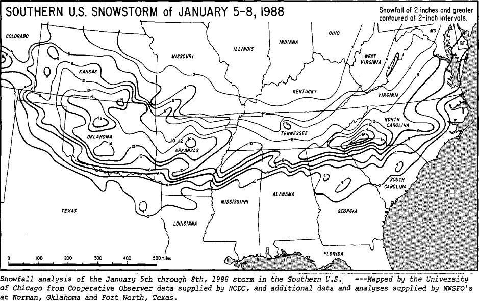
sdaccummap.jpg
 
Might be taboo because I am a transplant from Maryland but all of my memorable storms are from up that way. Lots of big ones but the February 2010 storms are the most memorable. We had 34" on Feb 6th
Feb2010.png

Then 2 days later another 22" from this overperformer
Feb_12_2010_snowfall_neusa.jpeg
Was pretty amazing to actually be in the bullseye and this is probably more memorable because I was much more into tracking storms at the point and watched it unfold. I moved to NC after that season and really not too much that is memorable has happened winter weather wise at my house SE of Raleigh in the almost decade I've lived here.
 
I know its early but here are some of my early predictions:

Birmingham: 18"
Atlanta:14"
Chattanooga: 22"
Greenville: 16"
Macon: 4" snow with 1" sleet/zr
Charlotte: 15"
Columbia: 6" with 1/2" ice/zr
Nashville: 10"

Haven't seen a 10"+ winter or single snow event in KCLT of that magnitude since 2003-04.

The strongest, coldest CAD events around here have been known to drop up to 8-10" before the inevitable IP/ZR changeover, hopefully something like that occurs next week. Some of the MSLP maps I've seen from the ECMWF given me flashbacks to this multi-day CAD event in mid-December 1930 that I analyzed a few years ago. Nearly a foot of snow fell in Charlotte before precip changed to IP, Raleigh observed primarily sleet & 6" of it. Snow/sleet totals practically doubled between about RDU airport & central Durham county.

December 15-18 1930 NC Snowmap.png
 
I'd love to see us get something that break my North Carolina snowfall record from January 2016 storm - 14" in Asheville.

Three storms in New Hampshire surpassed this record in single winter - 14" (1/4/18), 19" (3/8/18), and 24" (3/13/18). Yes, I saw 43" in a single week once... resulting in maximum snow depth of 28"... that'll never happen to me again o_O
 
Haven't seen a 10"+ winter or single snow event in KCLT of that magnitude since 2003-04.

The strongest, coldest CAD events around here have been known to drop up to 8-10" before the inevitable IP/ZR changeover, hopefully something like that occurs next week. Some of the MSLP maps I've seen from the ECMWF given me flashbacks to this multi-day CAD event in mid-December 1930 that I analyzed a few years ago. Nearly a foot of snow fell in Charlotte before precip changed to IP, Raleigh observed primarily sleet & 6" of it. Snow/sleet totals practically doubled between about RDU airport & central Durham county.

View attachment 27029
This is probably the storm that my grandmother told us about when I was growing up. It’s the time period it would have been. She said that the 13 inches that was on the ground in Concord was just like hardened concrete because of all the sleet and ice that fell with it. It stayed cold after the storm right on through Christmas and very little of it melted before Christmas Day.
 
The eastern NC Dec 3rd 2000 bombing we got. Cantore was setup in Raleigh as they were the bullseye. The storm slid east and we got a whopping 17 inches at my dads house. It was such a sharp cutoff at 95 that cantor had partly cloudy skies and flurries while we took a beating.
 
You must be toon young to remember this heartbreaker too
98c258b7ce94d480b01bddfab5368a25.gif


Sent from my SM-G975U using Tapatalk

We had 17 inches in Greenville. That 6-8 is so off its not even funny. I measured on my dads elevated aluminum jonboat that had an inch or 2 inches of melt on the bottom and 14 inches of good snow. Was a beast of a storm.
 
We had 17 inches in Greenville. That 6-8 is so off its not even funny. I measured on my dads elevated aluminum jonboat that had an inch or 2 inches of melt on the bottom and 14 inches of good snow. Was a beast of a storm.

I think this is the one I chased into Wendell. The sun was poking out in Raleigh with a heavy snow squall line to the east. It looked just like a lake effect snow band with the low cloud base.


Sent from my iPhone using Tapatalk
 
Not the south, but I got caught in this while visiting family. I was in the 32"+ zone. I unofficially measured 38", which was very difficult with the 60+ mph winds.

20130209_accum.gif
 
We had 17 inches in Greenville. That 6-8 is so off its not even funny. I measured on my dads elevated aluminum jonboat that had an inch or 2 inches of melt on the bottom and 14 inches of good snow. Was a beast of a storm.
This storm was a horrible bust for CLT metro. The forecast was for widespread 8-12” and literally there wasn’t a flake.
 
Figured I'd bring this here since I don't think areas in NC will experience anything as bad especially since the lead up likely wasn't that cold and it's likely going to just be a front end glaze, maybe up to .25 in areas if it even happens.

Dont you need temps solidly below freezing to get significant icing ? Seems like 31 or 32 is too warm to do major icing.

Nah. Not when the infamous 2/12/14 storm just as one example had this...

https://www.wunderground.com/history/daily/us/ga/augusta/KAGS/date/2014-2-12

Sadly with the new version of wunderground history, in some cases you don't see the precip and you don't here, but since I've looked a lot, it starts out as heavy cold rain, then switches to frozen and pretty much hangs around 31-32 degrees the entire day. That produced a couple of the pictures from this blog at home (as I was away then)...

https://markgelbart.wordpress.com/2014/02/27/ice-age-ice-storms/

And I'd say at least with this case, it affected life a good bit at least in the southern part of the county that didn't have Georgia Power and has an electric company that's out in the country instead. I remember my parents said they lost their power at about 9ish in the morning on 2/12. They did not get it back for almost a week. My friend was talking about not being able to take a shower and having to go to a place that has power to do it.
 
The grand daddy of huge cold air damming events:

This storm was an endurance race, lasting several days. It was a big sleet fest at RDU, w/ 6-7" of what was mostly sleet falling, nearly matching the mark received in Wake Co during the big Feb 87 event which produce 8" of sleet in Wake Forest.
compday.69.217.128.238.349.7.45.0.gif

compday.69.217.128.238.349.7.46.50.gif

December 15-18 1930 NC Snowmap.png
 
This storm is underrated if you ask me. Temps fell into the mid 20s with ripping fatties
59f1061eb80e95e3e2dd5f70049bc3a7.gif


Sent from my SM-G975U using Tapatalk
That was my first storm on Talkweather. GSO got shafted a bit, but March 2009 made up for it.

Long time, no see, SD! I moved to Durham from Florida this summer. :)
 
Was searching thru my winter storm archive for big events on this date & I found this gem in 1915.
December 20-21 1915 NC Snowmap.png


Apparently was the only storm SE of RDU-CLT that entire winter. When the dust finally settled, Fayetteville ended up being epically shafted.

Winter of 1915-16 NC Snowmap.png
 
Since we are within a month of the 20th anniversary of the Carolina Crusher, there will be a lot of folks looking back at that over the next several weeks. I’m wondering if there is case study available to discuss that storm and just what went wrong from a forecast standpoint for it to be missed. We’ve certainly seen 1-2 inch forecasts turn into 4-6 several times over the years, but it still baffles me that many areas went from absolutely no mention of snow to getting 12-24 inches 36 hours later.
 
Since we are within a month of the 20th anniversary of the Carolina Crusher, there will be a lot of folks looking back at that over the next several weeks. I’m wondering if there is case study available to discuss that storm and just what went wrong from a forecast standpoint for it to be missed. We’ve certainly seen 1-2 inch forecasts turn into 4-6 several times over the years, but it still baffles me that many areas went from absolutely no mention of snow to getting 12-24 inches 36 hours later.

I wouldn't be the best person to answer this, but I think people that remember this case say that the models from back then did a poor job of picking up convection or something that contributed and by the time that it started adjusting back, it was too late for it to not be a huge surprise.

What I do know is models have progressed so much since then that there are less huge surprises. Even cases like December 2010, there was a hint that a winter storm was possible and it just needed the phase to pan out.

Edit: Now I'm looking into this, and it looks like the computer models had a hard time handling a low pressure system in Canada, along with the system that produced the Carolina Crusher.
 
Last edited:
I wouldn't be the best person to answer this, but I think people that remember this case say that the models from back then did a poor job of picking up convection or something that contributed and by the time that it started adjusting back, it was too late for it to not be a huge surprise.

What I do know is models have progressed so much since then that there are less huge surprises. Even cases like December 2010, there was a hint that a winter storm was possible and it just needed the phase to pan out.

Edit: Now I'm looking into this, and it looks like the computer models had a hard time handling a low pressure system in Canada, along with the system that produced the Carolina Crusher.

This same system produced an amazing second of back to back weekend major ZRs in the ATL area and in much of N GA, which wasn't good for the Superbowl being held in ATL even tough it was indoors.

Per wiki: "In January 2000, two ice storms struck the Atlanta area within a week of each other. The second storm occurred during the week the Super Bowl was hosted. Despite the rare adverse weather conditions, city and state crews kept streets and sidewalks free of ice, and MARTA public transport kept running."
 
9 years ago this month, one of the very best of the last decade for my area. In a rare case, TWC nailed this snow forecast compared to the NWS/local mets, they were the most bullish/aggressive calling for 4-8 inches. I got 6.5 inches. Hartsfield-Jackson Int'l Airport got 4 inches I think because of the constant mixing of sleet/freezing rain.


9 years ago this month, one of the very best of the last decade for my area. In a rare case, TWC nailed this snow forecast compared to the NWS/local mets, they were the most bullish/aggressive calling for 4-8 inches. I got 6.5 inches. Hartsfield-Jackson Int'l Airport got 4 inches I think because of the constant mixing of sleet/freezing rain.


That's awesome. Local forecasts were better than they are now. Wish it would go back to that format.
 
I wouldn't be the best person to answer this, but I think people that remember this case say that the models from back then did a poor job of picking up convection or something that contributed and by the time that it started adjusting back, it was too late for it to not be a huge surprise.

What I do know is models have progressed so much since then that there are less huge surprises. Even cases like December 2010, there was a hint that a winter storm was possible and it just needed the phase to pan out.

Edit: Now I'm looking into this, and it looks like the computer models had a hard time handling a low pressure system in Canada, along with the system that produced the Carolina Crusher.
Thank you. I remember for those of us in the CLT metro area, we had a few inches of snow fall on Saturday afternoon and evening followed by a a light freezing rain most of the day on Sunday so schools and a lot of businesses were already closing for Monday. I remember the first mention of any precipitation for Monday that I had seen was on the 6pm Sunday newscast and WBTV had added a chance of light snow showers on Monday afternoon for areas S/E of I-85. Then on the 11pm they said that there could be up to an inch accumulation in those areas, but it wouldn’t be a huge deal because those were areas that already had several inches on the ground. I got to sleep in the next morning and when I woke up just after 8am, the NWS has just issued a WSW for 2-4 inches of snow but at that point I looked outside and could tell that we already had at least an inch. I was living in southeast Cabarrus County at the time near the Rocky River and Stanly County line, so I was right on the northwest fringe of the 10-14 inch totals... 10 miles southeast of me had 18-20 inches and 10 miles northwest of me had only 3-4
 
9 years ago this month, one of the very best of the last decade for my area. In a rare case, TWC nailed this snow forecast compared to the NWS/local mets, they were the most bullish/aggressive calling for 4-8 inches. I got 6.5 inches. Hartsfield-Jackson Int'l Airport got 4 inches I think because of the constant mixing of sleet/freezing rain.


Man this makes me miss snow even more. Thanks .


Sent from my iPhone using Tapatalk
 
Man this makes me miss snow even more. Thanks .


Sent from my iPhone using Tapatalk
The most memorable thing about that storm was when the first band of snow moved in from the SW moving NE along the I-20 corridor. Half of my snow came from that one band. I got a quick 3 inches in less than 2 hrs from that, it was so heavy I could barely see the houses across the street from me.

I think I still have some local news clips during the peak of this storm, if I find them I'll upload them and share them here.
This storm was also one of the few times that there was no worries about the temps the day going into it. The day before in CLT, the high was right around 30 and you could just tell by the way the clouds looked as the rolled in throughout the afternoon that a good snow was coming. That first band hit us right about 4:00am and within 15 minutes of the first flakes, everything was covered white
 
I don't know if anybody saw this, but Tomer Burg posted the p-type and vorticity maps from the Christmas day 2010 storm. Although unfortunatly the post is low resolution.
 
The quality of the photo is horrible but this was the Dec. 26, 2010 snow and we thought my parents golf cart, big tires and all, could handle it Lol.... nope.

1578063016835.png
 
Back
Top