• Hello, please take a minute to check out our awesome content, contributed by the wonderful members of our community. We hope you'll add your own thoughts and opinions by making a free account!

Tropical Potential Caribbean/Gulf system

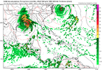
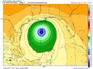
12Z ICON: major change in track vs prior runs! Instead of going into the W Gulf, it never goes W of 89W and landfalls (at ~997 mb) at Panama City, FL, at hour 159 on Thu night.
The placement and strength of this forecasted ULL over the central US is key to whether whatever forms near the Yucatan comes north early, or is left behind. All of the models have this feature with varying placement and timing. 12Z ICON has a complete capture.

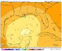
12Z GFS is slower with the development of the storm and the ULL leaves the storm partially behind.

12Z CMC has the ULL weaker and further W.

The pattern over the US that would steer whatever storm forms is coming into range at 4-5 days.
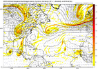
1726851725147.png
 
12Z UKMET: TCG is a little earlier than the prior two runs as it is Wednesday evening in NW Caribbean; it moves slowly N and then NW into south-central Gulf Fri morning (end of run) with it then at 997 mb and strengthening:

NEW TROPICAL CYCLONE FORECAST TO DEVELOP AFTER 132 HOURS
FORECAST POSITION AT T+132 : 19.7N 86.5W

LEAD CENTRAL MAXIMUM WIND
VERIFYING TIME TIME POSITION PRESSURE (MB) SPEED (KNOTS)
-------------- ---- -------- ------------- -------------
0000UTC 26.09.2024 132 19.7N 86.5W 1002 32
1200UTC 26.09.2024 144 21.1N 86.5W 1001 43
0000UTC 27.09.2024 156 21.7N 88.2W 1000 35
1200UTC 27.09.2024 168 23.4N 89.3W 997 40
Does the UKMET have the closed ULL over the Mississippi Valley?
 
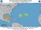
two_atl_7d0.png

3. Northwestern Caribbean Sea and Southern Gulf of Mexico:
A broad area of low pressure could form by the early to middle
part of next week over the northwestern Caribbean Sea. Thereafter,
gradual development of this system is possible, and a tropical
depression could form as the system moves slowly to the north or
northwest over the northwestern Caribbean Sea and into the southern
Gulf of Mexico through the end of next week.
* Formation chance through 48 hours...low...near 0 percent.
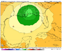
* Formation chance through 7 days...medium...50 percent.
 
Back
Top