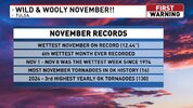
nothing really to be thankful for this year. I will say this was the last year doing turkey. Next year will be going out to eat or baked spaghetti at home
-
Hello, please take a minute to check out our awesome content, contributed by the wonderful members of our community. We hope you'll add your own thoughts and opinions by making a free account!
You are using an out of date browser. It may not display this or other websites correctly.
You should upgrade or use an alternative browser.
You should upgrade or use an alternative browser.
Pattern November 2024 💤 🔥
- Thread starter SD
- Start date
Blue_Ridge_Escarpment
Member
After the damage and loss of life I’ve seen around here and throughout WNC, plenty to be thankful for.nothing really to be thankful for this year. I will say this was the last year doing turkey. Next year will be going out to eat or baked spaghetti at home
43/8(!) at Spartanburg Memorial (not sure about that dew lol). Just set up the tree. Cold clear night ahead, enjoy it!
- Joined
- Jan 5, 2017
- Messages
- 3,608
- Reaction score
- 5,618
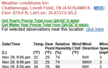
Looks like I'm getting my first freeze this morning! 32.2 now and a dew point of 22.and there it is...CHA's 1st freeze of the 2024-2025 season. November 29th at 9:00pm.
View attachment 155069
- Joined
- Jan 5, 2017
- Messages
- 3,608
- Reaction score
- 5,618
By the way, the heat island depicted on the GFS maps for Atlanta (and I'd venture to say, all of the metro areas), is way too big. Just .25 miles from the runways in Hapeville, GA it's already 30 degrees, colder than I am! Only places warmer are on the buildings downtown and at the actual airport.
The Tempest map data reveals the truth!
The Tempest map data reveals the truth!
23
SimeonNC
Member
25.4
GoDuke
Member
19.4 this morning.
ITUSETOSNOW
Member
22,
30 at KATL, finally.
30 at KATL, finally.
21.6 with a frost so heavy I could measure it like snow.
31.8 here
31.7 for the low, making this morning my first freeze of the season. Just half an hour north of here, at my parents' place, their low dropped to 29.3.
11/30 7:30AM: Grandfather Mountain, NC (5,280') current temperature is 8°F, with a wind chill of -20°F & gusts over 65 mph. #ncwx
25 at GSP.
LukeBarrette
im north of 90% of people on here so yeah
Meteorology Student
Member
2024 Supporter
2017-2023 Supporter
This is how you know it’s cold
ITUSETOSNOW
Member
Brasstown Bald, GA, 11, wind gust to 62, -18 WC.11/30 7:30AM: Grandfather Mountain, NC (5,280') current temperature is 8°F, with a wind chill of -20°F & gusts over 65 mph. #ncwx
Can someone please explain this: At the Morganton-Lenior airport, the temp went from 24 to 32 in the span of 20 minutes between 1:45 am and 2:05 am, with no apparent change in wind speed or direction, while the DP was falling.
My station never went below 31 all night, but the airport showed several hours of temps in the 20s, as did most of y'all's obs.
Maybe I'm reading it wrong or something.
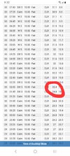
My station never went below 31 all night, but the airport showed several hours of temps in the 20s, as did most of y'all's obs.
Maybe I'm reading it wrong or something.

28.4
Max 84.2
Min 23.0
Avg 55.0
Rain 1.52
Min 23.0
Avg 55.0
Rain 1.52
Max 85.6
Min 23.5
Avg 53.8
Rain 1.66
Min 23.5
Avg 53.8
Rain 1.66
Max: 84.2
Min: 21.6
Avg: 55.6
Rain: 7.25”
Min: 21.6
Avg: 55.6
Rain: 7.25”
Down to 28 already
37 here. I moved to the mountains and reversed the climate lolDown to 28 already
Blue_Ridge_Escarpment
Member
Based on your obs last night and tonight I’m thinking you’re in an area that is prone to some wind. I’m in extreme NW Catawba county and was 20 last night and already down to 3237 here. I moved to the mountains and reversed the climate lol
I appreciate it37 here. I moved to the mountains and reversed the climate lol
Brent
Member
We had wind of about 3mph here, according to Tempest. The M-L apt last night had calm winds with temps around 24 and then winds out of the SW at 5, and the temp jumped to 31 in like an hour. That seems odd to me, to have a jump of that much.Based on your obs last night and tonight I’m thinking you’re in an area that is prone to some wind. I’m in extreme NW Catawba county and was 20 last night and already down to 32
Tonight, it's 36 still, with a N wind at 1 mph. Weird.
We had wind of about 3mph here, according to Tempest. The M-L apt last night had calm winds with temps around 24 and then winds out of the SW at 5, and the temp jumped to 31 in like an hour. That seems odd to me, to have a jump of that much.
Tonight, it's 36 still, with a N wind at 1 mph. Weird.
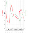
NCSCO temp graph is pretty far from ever getting to 24. Interesting
The obs had it. Idk
Oh I believe you. MRN is a few miles north, and about 100ft higher elevation. I don’t see any immediately obvious terrain influences. Could have just been a glitchThe obs had it. Idk
@Rain Cold moves out west and finds the one warm spot 
- Joined
- Jan 23, 2021
- Messages
- 4,008
- Reaction score
- 12,636
- Location
- Lebanon Township, Durham County NC
When I lived there, I did see that station do weird things on a couple occasionsCan someone please explain this: At the Morganton-Lenior airport, the temp went from 24 to 32 in the span of 20 minutes between 1:45 am and 2:05 am, with no apparent change in wind speed or direction, while the DP was falling.
My station never went below 31 all night, but the airport showed several hours of temps in the 20s, as did most of y'all's obs.
Maybe I'm reading it wrong or something.
View attachment 155118
You'd probably be shocked at how much the minutely obs can jump around. I've occasionally seen drops of 8-10 F in just a few minutes and not just at RDU. When I was in the WxChallenge, I saw that happen at several different locations just due to cold air draining right at sunrise and whatnot.We had wind of about 3mph here, according to Tempest. The M-L apt last night had calm winds with temps around 24 and then winds out of the SW at 5, and the temp jumped to 31 in like an hour. That seems odd to me, to have a jump of that much.
Tonight, it's 36 still, with a N wind at 1 mph. Weird.

