• Hello, please take a minute to check out our awesome content, contributed by the wonderful members of our community. We hope you'll add your own thoughts and opinions by making a free account!

Pattern November 2024 💤 🔥

But in all seriousness, I like riding with the ensemble mean ideas out at range. After the rex block / bomb cyclone mess gets cleaned out of the NE Pac, there appears to be a fairly consistent theme of a Pacific jet extension (originating from E Asia cold surge) leading to a Mod El Nino type look of Aleutian Low / trough anomaly N / NW of Hawaii with ridging pressed N into AK and east into the west coast, with Eastern or NE trough
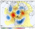
Nov 20 Euro Ens.png
 
Front came through Atlanta late morning-ish and it has turned sharply more windy. I’m going to the tech game tomorrow night and it looks like falling to the mid, maybe lower 40s.
Mighty nice that football weather finally showed up before the end of the regular season.
 
My personal rule of going all in is when it gets to D5-6. Right now, it’s at D9 so we’ll see.
Mine is < 96 hrs with positive trends on ops and < 144 hrs with positive trends on EPS. GEFS is total garbage and should frankly never be used for forecasting storm-specific details IMO. I’m as guilty as anyone of looking for any shred of hope including the GEFS on this forum, but I’d never stick my neck out using it professionally.

Let’s just say that other than the December ‘22 cold snap, I’ve not uttered the first word about winter potential professionally for low elevation NC the last couple winters.
 
But in all seriousness, I like riding with the ensemble mean ideas out at range. After the rex block / bomb cyclone mess gets cleaned out of the NE Pac, there appears to be a fairly consistent theme of a Pacific jet extension (originating from E Asia cold surge) leading to a Mod El Nino type look of Aleutian Low / trough anomaly N / NW of Hawaii with ridging pressed N into AK and east into the west coast, with Eastern or NE trough
View attachment 154433
I hear ya on the AI Euro....I'm waiting to see how it does since we really don't have any history to go off of. But I like what it's showing.

The ensembles have a tendency to put blues over the SE while showing a general big broad trough west to east. They seem to miss the recent tendency of troughing to roll back westward more vigorously underneath the AK ridge, which is understandable, since they're smoothing all of those details out way out in time.

But at least we can say that right now, they show a good signal for chillier weather around here. 🤷‍♂️
 
Going to be a little windy tonight.

Strong wind gusts of 25 to 40 mph likely this evening...

As a strong cold front sweeps through the region this evening, a
period of intense wind gusts as high as 25 to 40 mph is expected
across central North Carolina. These strong gusts will cross the
area west to east mainly between 8 PM and 1 AM. We`ve already
seen these gusts knock down trees to our northwest, and a few
downed trees are possible across our area through the evening.
This may produce isolated power outages.

Consider securing or bringing loose outdoor objects indoors, and
use extreme caution if you need to be out and about this evening.
Winds are expected to decrease later tonight.
 
Back
Top