Decided to start the thread to avoid confusion with Wednesday's threat.
-
Hello, please take a minute to check out our awesome content, contributed by the wonderful members of our community. We hope you'll add your own thoughts and opinions by making a free account!
You are using an out of date browser. It may not display this or other websites correctly.
You should upgrade or use an alternative browser.
You should upgrade or use an alternative browser.
Severe New Years Severe Weather Event
- Thread starter Snowfan
- Start date
HSVweather
Member
 Latest day 6 outlook for this event
Storm Prediction Center Jun 13, 2026 Day 4-8 Severe Weather Outlook
Severe weather, tornado, thunderstorm, fire weather, storm report, tornado watch, severe thunderstorm watch, mesoscale discussion, convective outlook products from the Storm Prediction Center.
www.spc.noaa.gov
tennessee storm
Member
Yeah looks to be a potent setup , already MEG nws Memphis tn using the word outbreak In this morning big afd s discussion .. I comment more as model runs become closer to event
Z
Zander98al
Guest
Wanna say something. The new years threat may be a multi pronged event. Two big severe events back to back two surface lows are going to swing through. First may be open but the second has a pretty potent cold front and closed low . And a fairly substantial flooding threat along north Alabama and Tennessee. Actually a very substantial threat coming up.
Z
Zander98al
Guest

Almost getting a filling of a repeat with all the rain from last 2 years.Forecast rainfall from GFS through around 7 days. View attachment 99362
Z
Zander98al
Guest
Also of note the nws of bham is leaning towards a more volatile solution of there being a large warm sector and potential outbreak of severe.
Z
Zander98al
Guest
This setup keeps getting more worrisome. As it gets closer. Very good shear a large warm sector, plenty of forcing. Good EML. Bowling ball ejecting and negatively tilted. All the makings for a significant event for the south. The cherry on top has been both global models putting out a sub 1000 mb low in the vicinity of the Memphis area. This is almost better than our average spring setup. Gee wiz. ?
This setup keeps getting more worrisome. As it gets closer. Very good shear a large warm sector, plenty of forcing. Good EML. Bowling ball ejecting and negatively tilted. All the makings for a significant event for the south. The cherry on top has been both global models putting out a sub 1000 mb low in the vicinity of the Memphis area. This is almost better than our average spring setup. Gee wiz. ?
As we saw with the last 2 outbreaks, the pattern is certainly conducive for another anomalous severe weather event.
Z
Zander98al
Guest

Z
Zander98al
Guest
Lol, I'd take it for a grain of salt as of right now honestly. Just a reassuring factor for what a lot of people are thinking about the event, according to how past similar events played out.Well that's not good.
A quick look at the 18z GFS looks like a really messy setup. Probably a far south AL/MS event.This setup keeps getting more worrisome. As it gets closer. Very good shear a large warm sector, plenty of forcing. Good EML. Bowling ball ejecting and negatively tilted. All the makings for a significant event for the south. The cherry on top has been both global models putting out a sub 1000 mb low in the vicinity of the Memphis area. This is almost better than our average spring setup. Gee wiz. ?
Z
Zander98al
Guest
Has looked like its shifted a bit south. Still 6 days away though. A bit of dry air aloft though, I would think it would be limited a bitA quick look at the 18z GFS looks like a really messy setup. Probably a far south AL/MS event.
Z
Zander98al
Guest
Thing to note GFS is starting to forecast convection on the gulf, this may limit severe potential a good bit if it verifies.
Z
Zander98al
Guest
Dude that 12z euro run is nutz. 992 mb in south Missouri as well ?
tennessee storm
Member
O shart… larger warm sector too. Puts west Tennessee more game nowDude that 12z euro run is nutz. 992 mb in south Missouri as well ?View attachment 99538
Last edited:
Z
Zander98al
Guest
Lol I'd wait for a few more model runs before I start believing in this solution though. Cause it wasn't even 24 hours ago. When the surface low was being shown not even making it into northern Alabama lol. The warm sector is huge though.O shart… larger warm sector too. Outa west Tennessee more game now
tennessee storm
Member
YeaLol I'd wait for a few more model runs before I start believing in this solution though. Cause it wasn't even 24 hours ago. When the surface low was being shown not even making it into northern Alabama lol. The warm sector is huge thou
Yeah but it’s got ensemble support there … red flag be honestLol I'd wait for a few more model runs before I start believing in this solution though. Cause it wasn't even 24 hours ago. When the surface low was being shown not even making it into northern Alabama lol. The warm sector is huge though.
Instead of a two wave look it has keyed on the first wave. From a quick look, it’s way more dangerous than the negative trough from yesterday’s GFS.Lol I'd wait for a few more model runs before I start believing in this solution though. Cause it wasn't even 24 hours ago. When the surface low was being shown not even making it into northern Alabama lol. The warm sector is huge though.
Z
Zander98al
Guest
Yeah that's what I noticed too. It had two twin lows almost that swung through and now it's down just too one deep low and a larger warm sector with better wind profiles.Instead of a two wave look it has keyed on the first wave. From a quick look, it’s way more dangerous than the negative trough from yesterday’s GFS.
Z
Zander98al
Guest
The GFS and euro are on board with it. I've just seen so many flops with weird stuff happening Id rather see a good bit of consistency.YeaLol I'd wait for a few more model runs before I start believing in this solution though. Cause it wasn't even 24 hours ago. When the surface low was being shown not even making it into northern Alabama lol. The warm sector is huge thou
Yeah but it’s got ensemble support there … red flag be honest
Yeah that's what I noticed too. It had two twin lows almost that swung through and now it's down just too one deep low and a larger warm sector with better wind profiles.
Still would like to see more turning with height from 850mb to 500mb.
tennessee storm
Member
Winds are veered off the today’s 12zrun today then it’s had all week this far. See if it’s trendStill would like to see more turning with height from 850mb to 500mb.
If winds become more unidirectional aloft and it can get a SSW at the surface, this could be a sizable event over the south.Winds are veered off the today’s 12zrun today then it’s had all week this far. See if it’s trend
Z
Zander98al
Guest
Still would like to see more turning with height from 850mb to 500
Usually our events end up having a southernly wind out of the surface. I'd expect it to be out of the south barring anything weirdIf winds become more unidirectional aloft and it can get a SSW at the surface, this could be a sizable event over the south.
tennessee storm
Member
South. Southeast winds from surface been some big events alsoUsually our events end up having a southernly wind out of the surface. I'd expect it to be out of the south barring anything weird
Z
Zander98al
Guest
Large hodo. Need too see a more curved look. Or sickle. Not enough veering. But most everything else is superb. 
NoSnowATL
Member
Nasty top analog.Large hodo. Need too see a more curved look. Or sickle. Not enough veering. But most everything else is superb. View attachment 99556
Z
Zander98al
Guest
Is that the ef4 Tuscaloosa tornado? From 2000?Nasty top analog.
Cad Wedge NC
Member
Yes, there was a significant tornado on the south side of Tuscaloosa on Dec 16, 2000 which killed 11 people.Is that the ef4 Tuscaloosa tornado? From 2000?
DAY 4 FROM THE SPC
Valid 011200Z - 061200Z
...DISCUSSION...
...Day 4/Saturday - Mid South into the Tennessee Valley and western
Appalachians...
Severe weather will likely be ongoing at the beginning of the period
from the early morning thunderstorms across Arkansas and vicinity.
The location of overnight convection will have a significant impact
on the zones within the broader risk area where a higher
severe-weather threat will exist. However, all guidance shows a
broad warm sector with a 50 knot low-level jet, which would foster
an environment favorable for all severe-weather types.
The greatest uncertainties are related to the northward extent of
the risk and the surface low track. Given the widespread convection
anticipated, a convectively reinforced warm front could set up
farther south than the synoptic front (as depicted by the 00Z GFS
and NAM). Also, global guidance still varies with the intensity and
location of the surface low as it tracks northeast. The 00z ECMWF
shows 3 separate mid-level shortwave troughs and therefore, develops
multiple elongated low-pressure areas along the front. Meanwhile the
06Z GFS and NAM show a more consolidated surface low development,
but vary significantly with the timing.
At this time, it appears eastern Mississippi into central and
northern Alabama will likely be the region within the broader 15
percent probabilities where a greater severe-weather threat may
exist. In this region, questions regarding moisture quality should
be resolved as a plume of higher-theta-e air will advect off the
Gulf at 850mb and into this region. Also, this is the region where
storms are expected to be during the diurnal peak when instability
should be greater. However, a limiting factor, particularly for the
tornado threat in this region, will be veered boundary-layer flow
depicted by most guidance. A surface low track through the Ohio
Valley and into the Northeast, as shown from the 00Z ECMWF and GFS,
would not be favorable for more backed surface flow needed for a
greater hodograph size and larger tornado threat
HSVweather
Member


A zone of greater severe-weather threat likely exists in the
northern Mississippi, northern Alabama, Tennessee region, but too
many uncertainties remain at this time to add higher probabilities.
These uncertainties include:
1. Questions regarding destabilization north of the Tennessee border
with Alabama and Mississippi.
2. Timing, intensity, and track differences with the surface low.
3. Potentially messy storm mode.
Higher probabilities may be necessary in later outlooks if these
issues resolve and a zone of greater threat becomes more clear.
Z
Zander98al
Guest
I call bullcrap on the sbcape projections lol, seems like all models including the HRRR. Undervalued moisture In the south with wensday event. May be a winter time issue with models ?. Although surface few points seem to be a bit lower, so who knows
...SUMMARY...
Widespread thunderstorms are expected from the ArkLaTex to the
Western Appalachians on New Year's Day. All severe-weather hazards
are possible including large hail, damaging winds, and a few
tornadoes.
...Synopsis...
A positively tilted upper-level trough will be centered over the
Great Basin at the beginning of the period. This trough will
maintain its positive tilt as it shifts eastward across the Plains
and into the Midwest by 12Z Sunday. A negatively tilted mid-level
shortwave trough will move quickly from the southern High Plains
across the Midwest and Ohio Valley Saturday to the northeast by
Sunday morning. A surface reflection of this mid-level shortwave
trough is expected to travel along the front, with a most likely
path from the Ozarks through the Ohio Valley and into the
Mid-Atlantic. However, some timing differences do remain, which
could shift both the track and the intensity of the surface low. The
00Z NAM was is slower than the GFS and ECMWF with the ejecting wave,
which results in a deeper and more northerly low-pressure track.
...ArkLaTex into the western Appalachians...
Severe thunderstorms will likely be ongoing in portions of
Mid-Mississippi Valley to the Arklatex at the beginning of the
period. Mid 60s dewpoints are forecast as far north as the
Tennessee/Kentucky border with upper 60s dewpoints across Louisiana,
Mississippi, and Alabama. This should be sufficient for at least
modest destabilization ahead of storm activity even with extensive
cloud cover in place. Greater instability is expected to develop
across Mississippi and Alabama where upper 60s dewpoints are
expected, and where guidance shows at least some breaks in the
clouds, which may allow some surface heating.
Strong shear will be in place across the entire warm sector. Expect
60 to 80 knots of mid-level flow and a broad low-level jet with 50+
knots of flow and a peak of 65 to 70 knots in the Tennessee Valley.
Most 00Z guidance shows more backed surface flow across the warm
sector than what was shown previously due to either a stronger
surface low, a farther south track, or the slower timing. However,
the flow still remains mostly south-southwest across the warm sector
which results in less low-level turning in the lowest 1 km of the
hodograph than would be expected for a greater tornado threat.
Therefore, differences in storm intensity will be primarily driven
by storm mode and regions of locally backed surface flow. The mostly
boundary-parallel surface flow will also be less favorable for
discrete supercell development within the warm sector. The strong
shear will favor some supercell structures within linear segments
and clusters, but storm mode may remain quite messy.
A zone of greater severe-weather threat likely exists in the
northern Mississippi, northern Alabama, Tennessee region, but too
many uncertainties remain at this time to add higher probabilities.
These uncertainties include:
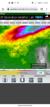
Euro looks way more dangerous wind field wise this morning.
HSVweather
Member
I agree, seems the trends have been for parameters to increase the closer to the event then verification is further south just like yesterday. It will be interesting to see how the CAMs trend as we get closer.I call bullcrap on the sbcape projections lol, seems like all models including the HRRR. Undervalued moisture In the south with wensday event. May be a winter time issue with models ?. Although surface few points seem to be a bit lower, so who knows
HSVweather
Member
 Noon Saturday the 850mb winds are 65+ over a large area on the 3km NAM.
Z
Zander98al
Guest
Is this a daytime event for Alabama?View attachment 99874Noon Saturday the 850mb winds are 65+ over a large area on the 3km NAM.