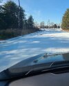
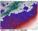
Bros getting my hopes up. Yes, there is model consensus. But we know how these things can shift NorthSaturday could be like Christmas in 2010. The entire state saw measurable snow fall
Sent from my iPhone using Tapatalk
-
Hello, please take a minute to check out our awesome content, contributed by the wonderful members of our community. We hope you'll add your own thoughts and opinions by making a free account!
You are using an out of date browser. It may not display this or other websites correctly.
You should upgrade or use an alternative browser.
You should upgrade or use an alternative browser.
Pattern NC Only Thread
- Thread starter SD
- Start date
lcpdk
Member
I'm just hoping we can catch a flight out of GSO Friday at 5pm to escape to Texas for the weekend. I don't care if we get delayed retuning on Sunday and get stuck at DFW or we need to extend our stay down there!
My forecasted low temps from NWS next 6 nights:
6
13
12
14
9
10
Lord only knows next Sunday and Monday nigh post the weekend snow storm. What a stretch
6
13
12
14
9
10
Lord only knows next Sunday and Monday nigh post the weekend snow storm. What a stretch
Btownheel
Member
My forecasted low temps from NWS next 6 nights:
6
13
12
14
9
10
Lord only knows next Sunday and Monday nigh post the weekend snow storm. What a stretch
I’m so freaking happy the CAD gods smiled on us. Doing this with widespread outages? #Nope
Feel for Nashville folks.
Sent from my iPhone using Tapatalk
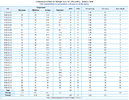
Here are the record low maxes and minimum for NC locations for the upcoming weekend into Monday. We stand a good chance to make a run at a few of these while we watch Goose Feathers fall from the skies.
From NWS
Record Low Temperatures:
January 28: KGSO: -2/1940, KRDU: 1/2000, KFAY: 10/1935
January 29: KGSO: -7/1940, KRDU: 7/2000, KFAY: 11/1986
January 30: KGSO: 4/1966, KRDU: 7/2014, KFAY: 8/2014
January 31: KGSO: 3/1966, KRDU: 3/1966, KFAY: 9/1934
February 1: KGSO: -4/1936, KRDU: 8/1981, KFAY: 1/1936
February 2: KGSO: 6/1971, KRDU: 5/1971, KFAY: 15/1971
Record Low Maximum Temperatures:
January 28: KGSO: 23/1986, KRDU: 23/1897, KFAY: 32/1961
January 29: KGSO: 23/1966, KRDU: 27/2014, KFAY: 28/2014
January 30: KGSO: 13/1966, KRDU: 19/1966, KFAY: 29/1966
January 31: KGSO: 22/1936, KRDU: 27/1948, KFAY: 22/1966
February 1: KGSO: 27/1971, KRDU: 28/1900, KFAY: 32/1981
February 2: KGSO: 30/1951, KRDU: 31/1994, KFAY:
This cold spell we're going through is very impressive. The second week in January was abnormally above normal, to a point I didn't think we'd have a chance to get back to normal. But yesterday RDU got back to normal for the month, and with more below normal temps the next four days we will surely have another below normal month.

I assume you got no-where near that yesterday right? I think RDU only made it to the mid-to-low 20sMy forecasted low temps from NWS next 6 nights:
6
13
12
14
9
10
Lord only knows next Sunday and Monday nigh post the weekend snow storm. What a stretch
Yeah, I was going to say this cold snap has been a little underwhelming vis a vis expectations. RDU only made it to 15 on Tuesday morning, too. I’ll take it, it’s still cold to set the table for the next storm while not destroying my heating bill quite as much.I assume you got no-where near that yesterday right? I think RDU only made it to the mid-to-low 20s
NBAcentel
Member
Mind as well give up spring break because next week is probably gonna be there early early spring breakKids aint making scool this week. High noon wednesday and froz3n rock solid still.
View attachment 190656
Btownheel
Member
Mind as well give up spring break because next week is probably gonna be there early early spring break
Yeh, we’re cooked here. I drove to check on my mom late yesterday afternoon. Any road outside of the city with some shade is legit dangerous as hell right now. Zero chance they go back this week. And then Saturday happens…
Sent from my iPhone using Tapatalk
I can't even get my car back up the hill to my house.Yeh, we’re cooked here. I drove to check on my mom late yesterday afternoon. Any road outside of the city with some shade is legit dangerous as hell right now. Zero chance they go back this week. And then Saturday happens…
Sent from my iPhone using Tapatalk
- Joined
- Jan 23, 2021
- Messages
- 4,602
- Reaction score
- 15,197
- Location
- Lebanon Township, Durham County NC
I see you’ve also joined the base of the driveway clubI can't even get my car back up the hill to my house.
Unpopular opinion but there will be a corridor of reduced precip between both systems. My guess is 95 corridor or a smidge west, with lesser amounts northern part of that corridor. My biggest concern with this system
TigerSnow
Member
Isn't this something we usually see with these types of systems? I'm pretty sure I have seen it over my area few times.Unpopular opinion but there will be a corridor of reduced precip between both systems. My guess is 95 corridor or a smidge west, with lesser amounts northern part of that corridor. My biggest concern with this system
- Joined
- Jan 23, 2021
- Messages
- 4,602
- Reaction score
- 15,197
- Location
- Lebanon Township, Durham County NC
Finally someone with a valid concernUnpopular opinion but there will be a corridor of reduced precip between both systems. My guess is 95 corridor or a smidge west, with lesser amounts northern part of that corridor. My biggest concern with this system
Although 18z euro suite, op and AI makes me feel better
We can only go down from here, right?Although 18z euro suite, op and AI makes me feel better
CraggyRider
Member
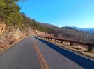
haw creek valley overlook my belovedTook a hike yesterday which included part of the Blue Ride Parkway and it looked like this:
View attachment 190866
CraggyRider
Member
You are correcthaw creek valley overlook my beloved
And over my area for some reason.Unpopular opinion but there will be a corridor of reduced precip between both systems. My guess is 95 corridor or a smidge west, with lesser amounts northern part of that corridor. My biggest concern with this system
wow
Member
And over my area for some reason.
Yeah I learned to move east. Thus I am in western Rowan Co now
TBH, I started to get excited this morning when seeing the RGEM with a near mirror image of the EC at H5 over the TN Valley and SE. I'll start worrying about liquid equivalents tomorrow, and deform axis/pivot point on Friday. Put the bucket and blade on the tractor this afternoon, dieseled up and ready to go. Without a doubt ENC's best look since 2010, and if we do in fact see an occlusion off the coast, we could be talking generational for areas under that pivot point.
That's a good place to be. I failed to research the area adequately. Hopefully just a stepping stone to West Jefferson.Yeah I learned to move east. Thus I am in western Rowan Co now
WPC doesn't use the word exceptional often, and for some odd reason they considerer NC the Mid-Atlantic, still.
WPC cluster analysis continues to show the primary driving factors
in the development of this impending winter storm are the
strength/speed/tilt of the approaching shortwave trough in the
Great Lakes and the spacing between the trough and the TPV over
southeast Canada. The meteorology is supportive of a significant
winter storm from the southern Appalachians and Carolinas on north
and east through the VA Tidewater. Just about all ensemble
guidance now show the shortwave trough over the OH Valley Friday
evening deepening into a powerful and highly anomalous closed low
that tracks into the southern Appalachians Saturday evening. By the
end of this forecast period (00Z Sun) the ECMWF 500mb heights are
approaching record low levels over the FL Panhandle for late Jan-
early Feb. As the 500mb low approaches, exceptional PVA and WAA
over the Mid-Atlantic coast will spawn low pressure along the
strengthening coastal front. This aligns well across the 12Z GFS
and 06Z ECMWF which show increasing 700mb Q-vector convergence near
the NC Outer Banks that fosters healthy mid-level ascent. This
aligns favorably beneath the diffluent left-exit region of a
>100kt 500mb jet streak located a the base of the closed 500mb low.
As the 700mb low tracks towards the Cape Fear region Saturday
night, the axis of heaviest snowfall will reside on the 700mb low's
northern and western flank.
You’re just in a bad spot for the Lee side shadow. There’s a clear picture of it taken after the March 2009 storm showing so much less snow cover in that spot. If we do see an upstate mesolow in this set up, it could help to increase your totalsThat's a good place to be. I failed to research the area adequately. Hopefully just a stepping stone to West Jefferson.
Zactheplumber
Member
My flight back from telluride is getting into rdu at 10pm Friday. I hope I’ll make it back.
- Joined
- Jan 23, 2021
- Messages
- 4,602
- Reaction score
- 15,197
- Location
- Lebanon Township, Durham County NC
If I remember correctly Caldwell and Burke were in a shadow during 1/23/03.You’re just in a bad spot for the Lee side shadow. There’s a clear picture of it taken after the March 2009 storm showing so much less snow cover in that spot. If we do see an upstate mesolow in this set up, it could help to increase your totals
That's what I'm counting on!You’re just in a bad spot for the Lee side shadow. There’s a clear picture of it taken after the March 2009 storm showing so much less snow cover in that spot. If we do see an upstate mesolow in this set up, it could help to increase your totals
They had smaller totals than adjacent foothill and mountain counties but still ended up around 6”If I remember correctly Caldwell and Burke were in a shadow during 1/23/03.
J1C1111
Member
Winter Storm Watch just went up.
RDU westward, especially Clt down into upstate SC, ULL gonna do work. East of RDU we need the coastal, I'm northern fringe and again gonna be a corridor of disappointment somewhere around I-95 to US 1.
The SREF will save us....RDU westward, especially Clt down into upstate SC, ULL gonna do work. East of RDU we need the coastal, I'm northern fringe and again gonna be a corridor of disappointment somewhere around I-95 to US 1.
We're screwed then lol. Only hope we have, is the coastal should trend/tick N/NW closer to go time.... they do 90% of the time. But that's all I gotThe SREF will save us....
We may have to wait until the coastal storm develops. Basically, not knowing where (or if) this dry slot develops until go time.We're screwed then lol. Only hope we have, is the coastal should trend/tick N/NW closer to go time.... they do 90% of the time. But that's all I got
Yeah writing on the wall for my neck of the woodsWeatherNext with a shift towards the Euro seeing a more expansive/robust ULL snow and some dry working into NE NC
View attachment 191131
Previous run
View attachment 191132

