• Hello, please take a minute to check out our awesome content, contributed by the wonderful members of our community. We hope you'll add your own thoughts and opinions by making a free account!

Pattern NC Only Thread

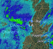
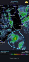
I’m encouraged by the radar right now. I like some of what I’m seeing. Dry slot filling in and good flow of moisture off the Atlantic. My interest is peaked. The HRRR does not have a good hold on the moisture. I don’t think it is handling the drier air in the atmosphere well and cutting moisture. Especially east of Raleigh.
The line that got here means business
 
All good, I've had flurries off and on all day. Dry air just too much to overcome here and I highly doubt the coastal low deep moisture makes it this far
Man, I hate it for you. I was hoping everyone would get at least a decent snow this time. Hopefully, it will come together for you later on today/night.
 
Man, I hate it for you. I was hoping everyone would get at least a decent snow this time. Hopefully, it will come together for you later on today/night.
It's picked up now and congrats to you. That western edge of heavy snow from the coastal is trying to nudge my way, not sure it will make it. Gonna be a brutal gradient
 
It's picked up now and congrats to you. That western edge of heavy snow from the coastal is trying to nudge my way, not sure it will make it. Gonna be a brutal gradient
Feels like it's inching ever so close, none the less it's snowing pretty good here in Roanoke Rapids, guessing it's doing pretty good a few miles away for you.
 
Feels like it's inching ever so close, none the less it's snowing pretty good here in Roanoke Rapids, guessing it's doing pretty good a few miles away for you.
It's been pretty good actually, ground covered, tapered off for now but better rates knocking on the doorsteps
 
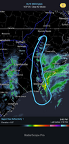
Likely the evenings main jam starting to take shape, this will continue to lift to the NNW, and likely stall for several hours as the low begins to bomb SE of HAT, basically a pivot as the orientation takes on a more N-S vs SW to NE. The 12z Euro has a min slp of 984 at 1am, and 968 at 7am. Current pressure is ~1000mb per SPC meso.

Where that occurs has the best shot of seeing double digits. Think area's down east are most likely assured a double digit snowfall as they are already half way there in many spots (MHX/Emerald Isle/Havelock/Swansboro) with still a lot more to go, those areas may not wrap till daybreak.
Screenshot 2026-01-31 at 3.57.48 PM.png
 
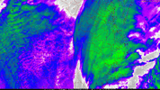
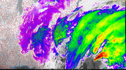
If you long loop the radar the returns approaching from the west hit US1 and get gobbled up which matches IR. This should be less dramatic as the upper low gets closer and to our south but by that point we've lost 80 % of the event so it'll be hard for many in the dry slot to do more than a dusting to maybe 2 since ratios are so high. I just can't see that coastal band getting back into this area it might take a run but 40 miles from my house for example is a tough ask.
 
If you long loop the radar the returns approaching from the west hit US1 and get gobbled up which matches IR. This should be less dramatic as the upper low gets closer and to our south but by that point we've lost 80 % of the event so it'll be hard for many in the dry slot to do more than a dusting to maybe 2 since ratios are so high. I just can't see that coastal band getting back into this area it might take a run but 40 miles from my house for example is a tough ask.
Well I forgot to look at a map, it might be able to get back into parts of wake, Franklin, Johnston. Maybe 401 is a decent expectation
 
What did the latest run show for rest of the evening for the triangle?
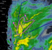
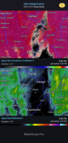
Wow looks like HRRR putting down over 3” in Raleigh area tonight. Still not sure if I’m buying that right now but dry slot does seem to be closing. RAP also showing a decent snow for the area
 
Back
Top