• Hello, please take a minute to check out our awesome content, contributed by the wonderful members of our community. We hope you'll add your own thoughts and opinions by making a free account!

Wintry More SE Snow ? (1/16-1/18)

More neutral tilting seems to make this longer duration
Yep this results in quite a few interesting things. Slower progress of the jet, a little more divergence aloft, almost a closed 850low near CLT and a deeper 700mb trough. If you loop the 700mb RH over the SE you can see the area across SC start to pivot east but it stays in place across NC. If the system itself wasn't moving east pretty quickly this would have potential to be a really big system. Even so, there are going to be a few bands/areas of heavy snowfall across the area tomorrow afternoon embedded in a larger area of snow. I'm still scared to get excited but damn this looks good
 
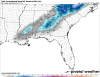
Winter storm warning issued for Charlotte.

Iredell-Davie-Catawba-Rowan-Lincoln-Gaston-Mecklenburg-Cabarrus-
York-Chester-
Including the cities of Statesville, Mooresville, Farmington,
Fork Church, Mocksville, Advance, Hickory, Newton, St. Stephens,
Salisbury, Lincolnton, Crouse, Gastonia, Charlotte, Concord,
Kannapolis, Catawba, Rock Hill, Chester, Cornwell,
and Great Falls
948 PM EST Tue Jan 16 2018

...WINTER STORM WARNING IN EFFECT UNTIL 2 PM EST WEDNESDAY...

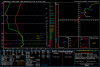
* WHAT...Heavy snow and black ice expected. Plan on difficult
travel conditions, including during the morning commute on
Wednesday. Total snow accumulations of 2 to 4 inches are
expected, with locally higher amounts.

* WHERE...Portions of upstate South Carolina and the Piedmont of
North Carolina along and west of Interstate 77.

* WHEN...Until 2 PM EST Wednesday.
 
Appears that the show is winding down for us. Assuming none of those returns to the southwest will be moving northward. I don't see much of anything to the west. Bham got dryslotted to hell and back.
 
Hearing that the RGEM is west

Eh, those maps aren't even out on the reg pcpn type site yet; hard to believe; but I guess the black & white charts (that are basically impossible to read) are out.
 
Here’s some sundown pictures of the snow and a few drone shots. I wanted to post it in the observation thread but it appears to be gone.

fd82691c4c17a025ada92764f4067bda.jpg


3604e83b1ea949b3719713f7d2acc90c.jpg


65c96b4c3485082c52b2b05cac92a68b.jpg


Sent from my iPad using Tapatalk
 
For those worried about ptype with HRRR, it's wrong. temps are absolutely dumb; @ surface level with precipitation falling. must be a modeling bug in a setup like this.

hence the tools talking about how rap warms up during precip etc; and dont realize that it's wrong.
 
Eh, those maps aren't even out on the reg pcpn type site yet; hard to believe; but I guess the black & white charts (that are basically impossible to read) are out.

Yep...Not good for the CAE...


Sent from my iPhone using Tapatalk
 
Looks the same as the 18z run, but max precip bumped up. Wake County is now 0.5"+ with 0.6" in far west Wake. 0.6-0.7" towards 85.
Yeah, the precip is not really staying west. Juat the area of higher totals is expanding and covering more ground.
 
Snow coming down at a good clip and steady. Ground turning white. Expecting 2-3 in.
 
Yeah the HRR totals are off so far unless something miraculous happens..had me at 2 to 3 inches and the latest still has those totals. I dunno what it's seeing lol.
 
Back
Top