ForsythSnow
Moderator
Over 2 is, but up to isn't. It's at the max they can do. Probably keeping it safe. If something soon says up to 3 or 2.5, they will upgrade.Isn’t that WSW criteria?
Over 2 is, but up to isn't. It's at the max they can do. Probably keeping it safe. If something soon says up to 3 or 2.5, they will upgrade.Isn’t that WSW criteria?
Oh okay I was about to say it look lower in the upstate that it did before but I was was looking at the hrrrx run that ran out to 36 hrs I thought this one did as wellYes it runs out to 18 hours each run. The new hrrrx runs out to 36 hours on the 0z,6z ,12, and 18z runs
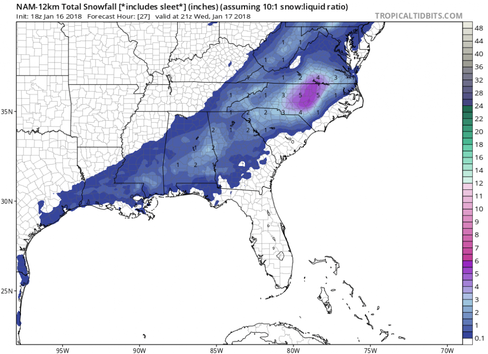
this will be a fun one to look back on to compare to the models almost every model has the downslope snow hole centered on my county (Lumpkin), so not expecting much here. weird to think i can see the peaks of the app spine from my house but in that distance the downslope will dry it up. hope at least you guys further south and west get a good one out of it.FFC just decided to cave here. Up to 2 inches in the latest WWA.
Not gonna be fun trying to go to the interstates in the morning though, fully expect alot of school closing announced this afternoon
")

This was basically the same exact forecast I had last night and I ended up with a little over 3 inches. Your area should do around the same or even bette I’d think. Good luck!URGENT - WINTER WEATHER MESSAGE
National Weather Service Raleigh NC
250 PM EST Tue Jan 16 2018
...WINTER STORM TO AFFECT ALL OF CENTRAL NORTH CAROLINA LATE
TONIGHT THROUGH WEDNESDAY...
.An Arctic cold front will approach from the west this evening,
then cross central NC overnight through Wednesday morning. The
arrival of the much colder air mass will interact with available
moisture to cause a swath of snow across much of central NC. The
precipitation may end as light freezing rain or freezing drizzle
Wednesday afternoon.
NCZ008>011-026>028-041>043-077-085-086-088-171045-
/O.UPG.KRAH.WW.Y.0003.180117T0400Z-180118T0000Z/
/O.NEW.KRAH.WS.W.0002.180117T0900Z-180118T0200Z/
Granville-Vance-Warren-Halifax-Franklin-Nash-Edgecombe-Wake-
Johnston-Wilson-Harnett-Scotland-Hoke-Cumberland-
Including the cities of Oxford, Butner, Creedmoor, Dabney,
Henderson, Norlina, Wise, Afton, Warrenton, Lake Gaston,
Roanoke Rapids, Pilot, Ingleside, Louisburg, Franklinton,
Nashville, Aventon, Red Oak, Sharpsburg, Spring Hope,
Rocky Mount, Raleigh, Cary, Smithfield, Clayton, Flowers, Selma,
Benson, Coats Crossroads, New Hope, Wilson, Dunn, Anderson Creek,
Timberlake, Duncan, Erwin, Angier, Lillington, Laurel Hill,
Laurinburg, Antioch, Ashley Heights, Raeford, Rockfish,
Silver City, Fayetteville, and Fort Bragg
250 PM EST Tue Jan 16 2018
...WINTER STORM WARNING IN EFFECT FROM 4 AM TO 9 PM EST
WEDNESDAY...
* WHAT...Moderate to heavy snow expected. Plan on difficult travel
conditions, possibly as early as the morning commute. Total snow
accumulations of 2 to 4 inches are expected, with locally higher
amounts up to 5 inches possible.
* WHERE...The eastern Piedmont, the Sandhills and most of the
coastal plain of central North Carolina.
* WHEN...From 4 AM to 9 PM EST Wednesday.
* ADDITIONAL DETAILS...Be prepared for significant reductions in
visibility at times, especially between 8 AM and 1 PM.
PRECAUTIONARY/PREPAREDNESS ACTIONS...
A Winter Storm Warning for snow means severe winter weather
conditions are expected. If you must travel, keep an extra
flashlight, food and water in your vehicle in case of an
emergency. The latest road conditions for North Carolina can be
found online at DriveNC.gov.
$$

Sun and winds will melt and evaporate that snow pretty quickly considering.Gonna be nice to have 1-3 inches of snow considering tomorrow's high is only 28 degrees
Yeah its amazing the power of the sun. Ive seen snow melt at 10 degrees with full sunshine.Sun and winds will melt and evaporate that snow pretty quickly considering.

Congrats Auburn.

 HRRR has snow around the Bham metro until 9. There will without a doubt be major road problems with some of the rates that are coming over the next 6 hours. You have models printing anywhere from 1-2 inches and temps will be in the 20's.
Not 18z...not out yet, I think it starts after the NAM.
HRRR has snow around the metro until 9. There will without a doubt be major road problems with some of the rates that are coming over the next 6 hours. You have models printing anywhere from 1-2 inches and temps will be in the 20's.
HRRR Snowfall totals continue to creep up.
This is the RDPS which is a great performer.....
Yeah but thats 12zThis is the RDPS which is a great performer.....