Leave it to the NAM to take the same data it had, ingest some new, and spit out an entirely different look @ H5 vs 12z.
-
Hello, please take a minute to check out our awesome content, contributed by the wonderful members of our community. We hope you'll add your own thoughts and opinions by making a free account!
You are using an out of date browser. It may not display this or other websites correctly.
You should upgrade or use an alternative browser.
You should upgrade or use an alternative browser.
Wintry More SE Snow ? (1/16-1/18)
- Thread starter GeorgiaGirl
- Start date

Xtreme Weather
Member
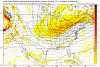
The PV and energy rounding the base on the NAM much stronger this run upper jet screaming in as well
HSVweather
Member
New Huntsville AFD “
This front looks to be a fairly quick
mover, but the deep moisture shown in model sounding combined with
strong forcing, could produce a quick few hundreths to around 0.10
inches of precipitation Monday night through Tuesday. This would
result in at least one half of an inch of snowfall over most of
northern Alabama and possibly up around 1 inch in some locations (if
heavier scenarios turn out to be right).”
Also, I usually read and rarely post because I have much to learn and enjoy reading and learning. Been lurking around since talkweather days, maybe 2013. Just want to thank everyone here.
Don't think my gif uploaded well but can definitely see a better H5 look.Umm NAM looks wayyyyyyy different at 78 than 12z. Woah...
Leave it to the NAM to take the same data it had, ingest some new, and spit out an entirely different look @ H5 vs 12z.
As Larry says, 18z is the happy hour run.
The NAM is pants bursting good for us Central Alabama folks !
RollTide18
Member
NAM does look better

 Here is close up.
Good 2-3 inch using 10:1 ratio
4-6 inches using 20:1 ratio
4-6 inches using 20:1 ratio

Feel like you could double these amounts. Would be 2-3+ easy!
Clayton Reid
Member
I know how you feel now. I was being unrealistic about the last system, and now these people are clearly in denial about the trend, and the poorness of the setup in general. It's more likely than not we won't get anything out of this and the next system will be just rain since that seems to pretty much always be a guarantee, assuming the cold air won't last too long because the Pacific is so damn fast, we have no high latitude blocking, and no southern California shortwave to bring in copious moisture to match up with cold in time. I agree. Let's just face reality now and stop leaving in a fantasy world. This is just the sad reality for snow lovers in the SE.Lol heaven forbid people have different opinions.
Let's change the forum to where everyone has to agree and be unrealistic. Good idea
Sent from my SM-J320VPP using Tapatalk
Rosie
Member
Depends.The NAM is pants bursting good for us Central Alabama folks !
SCweather
Member
At the end of the run, you can see a bit of moisture possibly linking together from the gulf into the main swath of precip. Also can see the energy off the coast of the Carolina's pulling in. May not work out for SC, but this may be a real good look for E NC.
ForsythSnow
Moderator
I don't trust the NAM at all, but given how everything has gone recently, I give it 1% of my trust. Just 1. If more and more models look like it, I'll give it 1.1%. I hope we see more like it, since that would really mean snow here. Basically, what it's showing at 10:1, could be realistic. Don't go extreme with 20:1 as the NAM overdoes QPF.
packfan98
Moderator
Here's the kuchera map for those hoping to squeeze out the higher ratios. It is a good percentage higher than the 10:1 map.

Brett
Member
New nam looks great heading into eastern va
B
Brick Tamland
Guest
And the NAM gives us life. The short range models did do well with the last storm.
Brett
Member
Also nam actually did very good with the last storm, curious if it does well with this one!!
Stormlover
Member
NAM rocks and says "what bad trend".

ForsythSnow
Moderator
If I can see the HRRR on board and the RGEM, I'll go all in. We got the NAM now, and the Euro hasn't been up to par recently. Seems to be taking the drugs that the GFS and CMC like to.And the NAM gives us life. The short range models did do well with the last storm.
Clayton Reid
Member
I don't blame you man. I wouldn't trust the bait the NAM is throwing out now as far as Earth is from the moon!I don't trust the NAM at all, but given how everything has gone recently, I give it 1% of my trust. Just 1. If more and more models look like it, I'll give it 1.1%. I hope we see more like it, since that would really mean snow here. Basically, what it's showing at 10:1, could be realistic. Don't go extreme with 20:1 as the NAM overdoes QPF.
Xtreme Weather
Member
Also seems to be very weak low level circulation over northern GOM
It is the start of the reverse trend. Lol. Everything will trend better now. (Happy throughts) lolNAM rocks and says "what bad trend".
Clayton Reid
Member
Don't take the bait and go on this rollercoaster again. I wouldn't even think of putting much stock in that as of right now anyway given how fickle the setup is in general and models all over the place. Please take with a grain of salt so u won't be disappointed if it changes again.And the NAM gives us life. The short range models did do well with the last storm.
Stormlover
Member
Wow at the negative people on here. Remember, the NAM even when it was the outlier has done great several events over the last year.
ForsythSnow
Moderator
Yeah, the NA< did good with the Dec 9 storm here. Probably one of the best. GFS was stubborn, CMC was okay, and the Euro wasn't quite right. The NAM didn't do good last few events because it was mostly fringe regions it was bad in. I think that if you are in the NAM's target area, you have a chance. Assuming it doesn't all poof in 4 runs.Wow at the negative people on here. Remember, the NAM even when it was the outlier has done great several events over the last year.
GeorgiaGirl
Member
Also seems to be very weak low level circulation over northern GOM
If that were to happen, and I mean a big IF, that changes everything.
Stormlover
Member
Remember, that is only 10:1 on the snow map, and it is going to be much better than that.
NoSnowJoe
Member
Once again, right on the WRONG edge of the snow line
No kidding great look.18z NAM would probably be a huge NC hit. We will see how it looks inside of 60 hours tomorrow.
Sent from my SM-G955U using Tapatalk
 What is unreal about this is the air temp. Low - mid 20’s when the precip starts. Unreal. You don’t see that much in the south.
GeorgiaGirl
Member
Once again, right on the WRONG edge of the snow line
The NAM only goes out to 84 hours. It's not done at that point...
Jon
Member
***18z Nam is nearly identical (actually a bit better and more SW) than the 00z Euro was. Extrapolated out, big hit for Central NC. [NAM has the blue wind barbs]

Sent from my iPhone using Tapatalk

Sent from my iPhone using Tapatalk
Last edited:
Darklordsuperstorm
Member
Just an observation. I come here to get informed about possible upcoming extreme weather events. This forum is an excellent resource and those involved have a done more than an excellent job in making this an elite platform for weather information. With that said I feel like the back and forth soap opera that shows up from time to time and the eagerness to jump down the throat of members who post something you disagree with and the arrogance that sometimes comes with that can take away from the quality of the discussion that is on going.
View attachment 2805 What is unreal about this is the air temp. Low - mid 20’s when the precip starts. Unreal. You don’t see that much in the south.
One of the reasons I’m pullig so hard for this system. Jan of 2014 was the only time I saw snow stick to everything and so fast. One inch in those temps would be amazing and so cool to see.
Jon
Member
Also looks better than yesterday's 12z GFS.
Just noticed I said 12z, obviously meant 18z! And I agree about the GFS, worlds apart

Sent from my iPhone using Tapatalk
Ok so let's talk disclaimer first. Lol it's the NAM blah blah blah I know and agree
***I would argue that there is a very real possibility we could see a weak sfc reflection with a low under that awesome dual jet structure. Even if we don't, imho it won't take much more to have more moisture and qpf.


***I would argue that there is a very real possibility we could see a weak sfc reflection with a low under that awesome dual jet structure. Even if we don't, imho it won't take much more to have more moisture and qpf.
Attachments
Very nice write up delta...Ok so let's talk disclaimer first. Lol it's the NAM blah blah blah I know and agree
***I would argue that there is a very real possibility we could see a weak sfc reflection with a low under that awesome dual jet structure. Even if we don't, imho it won't take much more to have more moisture and qpf.
View attachment 2807 View attachment 2808 View attachment 2809 View attachment 2810
Storm5
Member
From Memphis. Inch or less

Sent from my SM-J320VPP using Tapatalk

Sent from my SM-J320VPP using Tapatalk