SE WAKE!
Sent from my iPhone using Tapatalk
-
Hello, please take a minute to check out our awesome content, contributed by the wonderful members of our community. We hope you'll add your own thoughts and opinions by making a free account!
You are using an out of date browser. It may not display this or other websites correctly.
You should upgrade or use an alternative browser.
You should upgrade or use an alternative browser.
Pattern Microwave March
- Thread starter SD
- Start date

Hope you have a hotel room booked in NE TN !
Sent from my iPhone using Tapatalk
Storm5
Member
Hope you have a hotel room booked in NE TN !
I'm not changing . Getting things approved with SD and the wife is complete hell
Sent from my iPhone using Tapatalk
we obviously need to start charging member dues so you can get more roomsI'm not changing . Getting things approved with SD and the wife is complete hell
Sent from my iPhone using Tapatalk
Webberweather53
Meteorologist

Mid-Atlantic weenies are salty af rn lol.

accu35
Member
Hahaha, it's about time you post gif Lol. Welcome to our craziness
I'm sorry good to see the southern trend but much work to be done for parts of AL/GA I'm pulling like the dickens though cause its probably last shot at winter weather in the SE for most of us and got nothing left but to say hey its trended this far south so far can't never say never on it to get down here too
W
WeatherLC
Guest
Hey guys! Im excited. I might try to head up to the GSPNP this weekend and see if I can do a little snow chasing.
Webberweather53
Meteorologist
The clipper that will lay down a decent amount of snow in the I-80 corridor should set the northern boundary of the storm later this following weekend and hence will aid in refrigerating the strong Cp airmass that will invade the eastern US late this week out ahead of our storm. This s/w is still over the Gulf of Alaska and won't be sampled into the upper air network until later on Friday when it comes onshore of the Pacific Northwest, thus, we're still at least 2-3 days away from making any solid determinations wrt track, intensity, and location specific impacts from this system.

olhausen
Member
To all who are planning to go to Kentucky. If this storm does end up being a good one for north Tennessee and southern Kentucky rather then Louisville, feel free to pm and I'll give you directions to my little town of White House. It's a very nice little town with almost no traffic and literally zero crime. There's a number of newly built hotels with restaurants gas stations and even a super Walmart. Plus it's right off the I65 exit! The euro shows bowling green Kentucky getting 5-6 inches Which is only 35-40 minutes north of white house so That's a good area also. Anyways I know a lot of the area in northern Tennessee and southern Kentucky so feel free to pm me with any questions you guys might have.Go to Kentucky , you can book a room and cancel it. I've got 4 rooms booked just so I have options depending on how everything unfolds
Sent from my iPhone using Tapatalk
I went through White House, TN 2 years ago !! I nearly stayed in a hotel there but decided to stay in Bowling Green instead when I went on a snow chase ! White House is a nice little town. BTW, I've always wondered how it got the name White House. Did it get the name from the White House in DC ?To all who are planning to go to Kentucky. If this storm does end up being a good one for north Tennessee and southern Kentucky rather then Louisville, feel free to pm and I'll give you directions to my little town of White House. It's a very nice little town with almost no traffic and literally zero crime. There's a number of newly built hotels with restaurants gas stations and even a super Walmart. Plus it's right off the I65 exit! The euro shows bowling green Kentucky getting 5-6 inches Which is only 35-40 minutes north of white house so That's a good area also. Anyways I know a lot of the area in northern Tennessee and southern Kentucky so feel free to pm me with any questions you guys might have.
olhausen
Member
Yeah bowling green got about 10 inches from that storm and I got 2 inches of sleet and another 2 inches of snow from that system. Then a day later a clipper came through at night and dropped a solid two inches while it was about 13 Degrees outside. I believe that was the coldest temps I've seen snow fall while living up here.I went through White House, TN 2 years ago !! I nearly stayed in a hotel there but decided to stay in Bowling Green instead when I went on a snow chase ! White House is a nice little town.
Webberweather53
Meteorologist
I can imagine the EPS probably going to come south again this run, SE Canada/New England vortex is even deeper, slower, and further SW.
All I can say is keep going vortex and keep that low digging south tooI can imagine the EPS probably going to come south again this run, SE Canada/New England vortex is even deeper, slower, and further SW.View attachment 365
pcbjr
Member
Just popping in (but mostly keeping quiet since it's your back yard and not mine) to say - Here's Hoping Folks!!

Yes I saw 10 inches of snow in Bowling Green. Most snow i've seen since 93 so it was worth the trip. It was also a powdery type snow which made it easier to drive in if i recall correctly. I was surprised how easy it was to drive in 10 inches of snow.Yeah bowling green got about 10 inches from that storm and I got 2 inches of sleet and another 2 inches of snow from that system. Then a day later a clipper came through at night and dropped a solid two inches while it was about 13 Degrees outside. I believe that was the coldest temps I've seen snow fall while living up here.
Webberweather53
Meteorologist
Yep, EPS went south again...

Storm5
Member
Yep, EPS went south again...
View attachment 366
This earlier eps data is the sh**. It's about time
Sent from my iPhone using Tapatalk
Storm5
Member
Lots of light events on the 12z eps


Sent from my iPhone using Tapatalk


Sent from my iPhone using Tapatalk
Webberweather53
Meteorologist
This earlier eps data is the sh**. It's about time
Sent from my iPhone using Tapatalk
Yep, totally agree... Even starting to see a few EPS members creep down into the upstate of SC. Lol e23.
Attachments
olhausen
Member
If this storm goes as far south today as it has in the last 2 days I might be headed down to Alabama to see snowYep, EPS went south again...
View attachment 366
")
Good to see majority of ensemble members from both suites are against anything for the CAE area. Keeps me from getting let down. Nice to watch something and "hope" it surprises me.
ForsythSnow
Moderator
E 23 FTW! Looking better for sure. Not sure if I am rooting more for no snow in the MA or for snow in the south lol.Yep, totally agree... Even starting to see a few EPS members creep down into the upstate of SC. Lol e23.
pcbjr
Member
All we need is 6 hours driving time further south ... LOLYep, EPS went south again...
View attachment 366
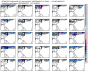
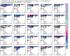
For anyone wondering why the eps "mean" shows something down to the Midlands of SC: It's because one member is an outlier that pops the low off the coast of GA and is colder. There are 3 or 4 other members kinda like that, but likely warm or the precp type is not snow. Fwiw.
Storm5
Member
E 23 FTW! Looking better for sure. Not sure if I am rooting more for no snow in the MA or for snow in the south lol.
That's the 00z run e23 on the 12z run looks nothing like that

Sent from my iPhone using Tapatalk
Webberweather53
Meteorologist
Mid-Atlantic isn't quite done yet even after the storm this weekend that passes to their south...

ForsythSnow
Moderator
Watch that storm fizzle out in the end or go way north lol.Mid-Atlantic isn't quite done yet even after the storm this weekend that passes to their south...
View attachment 369
I know, but it's hilarious to see lol.That's the 00z run e23 on the 12z run looks nothing like that
Sent from my iPhone using Tapatalk
Storm5
Member
I'm about to get rocked

Sent from my iPhone using Tapatalk

Sent from my iPhone using Tapatalk
Cad Wedge NC
Member
I counted 18 members with greater than 2 inches for MBY, and several more with minor accumulations. This is looking better and better with time. Although, the storm is weaker on the Euro as a whole.Yep, totally agree... Even starting to see a few EPS members creep down into the upstate of SC. Lol e23.
What area are you in ?I counted 18 members with greater than 2 inches for MBY, and several more with minor accumulations. This is looking better and better with time. Although, the storm is weaker on the Euro as a whole.
Storm5
Member

Sent from my iPhone using Tapatalk
So basically, lets ignore the GFS with hurricane stuff? That sucks cause I do not mind the GEFS track forecasts.
LOL! The MA forum is epic right now! They were waiting for the Euro to bring them hope and got there dreams crushed!
ALEET! ALEET! It's gotta come N!!!
ALEET! ALEET! It's gotta come N!!!
B
Brick Tamland
Guest
From reading Greg Fishel's post on facebook, the Euro has been all over the place the last 5 runs from nothing to 6 inches of snow for RDU. But it looks like the other models have started showing the threat moving further south, too. Crazy to be tracking a possible decent snow storm for here in March.
pcbjr
Member
Lucky you - and I mean that sincerely ...From reading Greg Fishel's post on facebook, the Euro has been all over the place the last 5 runs from nothing to 6 inches of snow for RDU. But it looks like the other models have started showing the threat moving further south, too. Crazy to be tracking a possible decent snow storm for here in March.
Storm5
Member
LOL! The MA forum is epic right now! They were waiting for the Euro to bring them hope and got there dreams crushed!
ALEET! ALEET! It's gotta come N!!!
Now they have punted Sunday and latched on to the day 8 system on the eps. I love it
Sent from my iPhone using Tapatalk
B
Brick Tamland
Guest
You know what's going to happen. It starts out to the north, goes way south at some point, and then adjusts back NW a couple of days out. It's the same movie.
Cary_Snow95
Member
I think my biggest concern after the 12z runs is the strength of the s/w. It just keeps getting weaker and weaker. The 18z NAM followed the trend of weakening it. Right now I am hoping for some token flakes but covering the ground would be a jackpot.From reading Greg Fishel's post on facebook, the Euro has been all over the place the last 5 runs from nothing to 6 inches of snow for RDU. But it looks like the other models have started showing the threat moving further south, too. Crazy to be tracking a possible decent snow storm for here in March.
Cary_Snow95
Member
I would imagine we want the vort in the NE to keep digging just a touch and have the s/w dig to get a stronger system while staying south