Might be several days before we hear from the worst hit areas and get pictures/videos from there
-
Hello, please take a minute to check out our awesome content, contributed by the wonderful members of our community. We hope you'll add your own thoughts and opinions by making a free account!
You are using an out of date browser. It may not display this or other websites correctly.
You should upgrade or use an alternative browser.
You should upgrade or use an alternative browser.
Tropical Melissa
- Thread starter SD
- Start date
Shaggy
Member
I like Ryan hall but his estimation of 80mph winds in montego bay look awfully low
Off Telegram. Cant load videos. Heres a couple screen shots


SUMMARY OF 400 PM EDT...2000 UTC...INFORMATION
----------------------------------------------
LOCATION...18.4N 77.9W
ABOUT 10 MI...15 KM S OF MONTEGO BAY JAMAICA
ABOUT 215 MI...345 KM SW OF GUANTANAMO CUBA
MAXIMUM SUSTAINED WINDS...150 MPH...240 KM/H
PRESENT MOVEMENT...NNE OR 25 DEGREES AT 8 MPH...13 KM/H
MINIMUM CENTRAL PRESSURE...914 MB...26.99 INCHES
150/914
Holy textbook
2025
...CENTER OF MELISSA EMERGING FROM THE NORTHERN COAST OF WESTERN
JAMAICA...
...DAMAGING WINDS. CATASTROPHIC FLASH FLOODING, AND
LIFE-THREATENING STORM SURGE CONTINUES IN JAMAICA...
SUMMARY OF 500 PM EDT...2100 UTC...INFORMATION
----------------------------------------------
LOCATION...18.5N 77.7W
ABOUT 15 MI...20 KM E OF MONTEGO BAY JAMAICA
ABOUT 200 MI...325 KM SW OF GUANTANAMO CUBA
MAXIMUM SUSTAINED WINDS...145 MPH...230 KM/H
PRESENT MOVEMENT...NNE OR 25 DEGREES AT 8 MPH...13 KM/H
MINIMUM CENTRAL PRESSURE...921 MB...27.20 INCHES
145/921
Hurricane Melissa Discussion Number 30
NWS National Hurricane Center Miami FL AL132025
500 PM EDT Tue Oct 28 2025
The eye of Melissa made landfall in western Jamaica near 17Z with
maximum sustained winds estimated at 160 kt and a central pressure
near 892 mb. Since that time, the hurricane has been weakening over
the mountains of western Jamaica with the eye disappearing and some
warming of the convective cloud tops. Based on these changes, the
initial intensity has been reduced to a highly uncertain 125 kt.
NOAA and Air Force Reserve Hurricane Hunter aircraft are scheduled
to investigate Melissa this evening to provide better information
on how much it has weakened. It should be noted that while
Melissa's landfall intensity is among the strongest ever recorded
in the Atlantic basin, it will take extensive post-analysis to
determine exactly where it ranks among landfalling Atlantic
hurricanes.
The initial motion is now 025/7. A turn toward the northeast with
an increase in forward speed is expected this evening, and this
should bring the center near or over southeastern Cuba late tonight
or early Wednesday. After that, an even faster motion toward the
northeast should bring the center through the southeastern and
central Bahamas on Wednesday and near Bermuda Thursday or Thursday
night. After passing Bermuda, the cyclone should continue quickly
northeastward into the north Atlantic. The track guidance envelope
has shifted a little to the left (north and west) through 72 h
since the last advisory, and the new forecast track during this
time is also shifted a little to the north and west.
While the center of Melissa is now emerging over water, it will
probably not re-intensify significantly before landfall in Cuba due
to the limited amount of time before landfall and an upper-level
wind environment that is becoming less favorable. Based on this, the
intensity forecast calls for little change in strength before
Melissa reaches Cuba. After leaving Cuba, Melissa should encounter
increasing southwesterly vertical shear that should cause gradual
weakening, although the cyclone should still be at hurricane
strength when it passes near Bermuda. Based on global model
guidance, Melissa is forecast to become a strong extratropical
cyclone over the North Atlantic by 96 h.
——————-
FORECAST POSITIONS AND MAX WINDS
INIT 28/2100Z 18.5N 77.7W 125 KT 145 MPH
12H 29/0600Z 19.9N 76.7W 120 KT 140 MPH
24H 29/1800Z 22.2N 75.3W 100 KT 115 MPH
36H 30/0600Z 25.0N 73.2W 95 KT 110 MPH
48H 30/1800Z 28.9N 70.0W 90 KT 105 MPH
60H 31/0600Z 33.8N 64.8W 85 KT 100 MPH
72H 31/1800Z 39.0N 58.3W 70 KT 80 MPH
96H 01/1800Z 48.4N 42.2W 50 KT 60 MPH...POST-TROP/EXTRATROP
120H 02/1800Z 54.8N 25.1W 40 KT 45 MPH...POST-TROP/EXTRATROP
$$
Forecaster Beven
BULLETIN
Hurricane Melissa Intermediate Advisory Number 30A
NWS National Hurricane Center Miami FL AL132025
800 PM EDT Tue Oct 28 2025
...POWERFUL MELISSA MOVING TOWARD EASTERN CUBA...
...CONDITIONS EXPECTED TO DETERIORATE RAPIDLY OVER THE NEXT SEVERAL
HOURS...
SUMMARY OF 800 PM EDT...0000 UTC...INFORMATION
----------------------------------------------
LOCATION...18.8N 77.2W
ABOUT 50 MI...80 KM ENE OF MONTEGO BAY JAMAICA
ABOUT 160 MI...260 KM SW OF GUANTANAMO CUBA
MAXIMUM SUSTAINED WINDS...125 MPH...205 KM/H
PRESENT MOVEMENT...NNE OR 30 DEGREES AT 8 MPH...13 KM/H
MINIMUM CENTRAL PRESSURE...950 MB...28.06 INCHES

GeorgiaGirl
Member
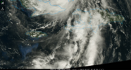
Just that fast the eye is already clearing out. Wow. An hour ago the CDO was more or less uniform with no visible eye on IR.
View attachment 175790
Luckily it won't have much time over water, guessing it'll landfall in Cuba tonight as a strong 3 probably.
iGRXY
Member
Likely a 4Luckily it won't have much time over water, guessing it'll landfall in Cuba tonight as a strong 3 probably.
Brent
Member
Assuming the 892 holds up. We may not know for sure for months 
She's back to a 4. 130 mph winds/950 mb as of 11 pm advisory.
Stormsfury
Member
Melissa has regained Cat 4 status at 130mph again. Crazy amount of lightning yet again in the larger eyewall
Brent
Member
Satellite and radar imagery indicate that Melissa has made landfall
in the Cuban province of Santiago de Cuba near the city of Chivirico
at 310 AM EDT (0710 UTC) with maximum sustained winds near 120 mph
(195 km/h). The minimum central pressure estimated from the earlier
reconnaissance data is 952 mb (28.12 inches).
in the Cuban province of Santiago de Cuba near the city of Chivirico
at 310 AM EDT (0710 UTC) with maximum sustained winds near 120 mph
(195 km/h). The minimum central pressure estimated from the earlier
reconnaissance data is 952 mb (28.12 inches).
Shaggy
Member
As bad as things will be in Jamaica after this so far the death toll seems to only be one person just imagine if a storm this size and intensity hit Haiti or a much more undeveloped country
Brent
Member
As bad as things will be in Jamaica after this so far the death toll seems to only be one person just imagine if a storm this size and intensity hit Haiti or a much more undeveloped country
I would be very skeptical of that right now the communications are down everywhere. I dunno if we even had an idea about Helene for days
I mean we did get lucky it missed Kingston but I dunno if we'll get that lucky
There's 3 deaths in Jamaica already apparently
Last edited:
I would be very skeptical of that right now the communications are down everywhere. I dunno if we even had an idea about Helene for days
I mean we did get lucky it missed Kingston but I dunno if we'll get that lucky
There's 3 deaths in Jamaica already apparently
I’m especially concerned about casualties due to the catastrophic flash flooding from epic rainfall amounts in mainly inland areas in valleys. Some of the footage yesterday was horrific, especially at Mandeville.

Jeff P on yesterdays live feed in Santa Cruz was saying that the rain was the heaviest he had remembered in all of his life.
Last edited:
Brent
Member
I’m especially concerned about casualties due to the catastrophic flash flooding from epic rainfall amounts in mainly inland areas in valleys. Some of the footage yesterday was horrific, especially at Mandeville.
Brad P on yesterdays live feed in Santa Cruz was saying that the rain was the heaviest he had remembered in all of his life.
Just saw a report of 25 dead in Haiti and Haiti was far from the core of this
It's gonna be weeks before we know about the hardest hit areas

Santa Cruz was hit by the western eyewall that was unusually intense. The damage there from both fresh water flooding and extreme wind damage must be horrific.I’m especially concerned about casualties due to the catastrophic flash flooding from epic rainfall amounts in mainly inland areas in valleys. Some of the footage yesterday was horrific, especially at Mandeville.
Brad P on yesterdays live feed in Santa Cruz was saying that the rain was the heaviest he had remembered in all of his life.
Also, has anyone heard from Josh since the storm?
I have heard that comms are down in the area.Santa Cruz was hit by the western eyewall that was unusually intense. The damage there from both fresh water flooding and extreme wind damage must be horrific.
Also, has anyone heard from Josh since the storm?
Brent
Member
I have heard that comms are down in the area.
Jeff about 10 miles from Josh did make a post last night and said it was really really bad.
But Josh usually always disappears for a few days I've noticed
GeorgiaGirl
Member
Santa Cruz was hit by the western eyewall that was unusually intense. The damage there from both fresh water flooding and extreme wind damage must be horrific.
Also, has anyone heard from Josh since the storm?
It wouldn't be surprising if we didn't for at least another day or two honestly. He doesn't carry a Starlink with him and comms are bad to pretty much gone in the parish he was at.
If we get towards the end of the weekend and still nothing, it'll be fair to wonder.
Oh, I thought for sure he had Starlink. Thx!It wouldn't be surprising if we didn't for at least another day or two honestly. He doesn't carry a Starlink with him and comms are bad to pretty much gone in the parish he was at.
If we get towards the end of the weekend and still nothing, it'll be fair to wonder.
Gonna be a big problem for someone
It was indeed a big problem
God forbid if we ever get a major that directly strikes Haiti and is slow-moving
From 4 hours ago, this stream from Jeff P. shows he and his friend driving around surveying the damage starting in Santa Cruz, Jamaica, where’s he’s been and which was just to the east of the worst damage, and then heading west to the worst damage with their main goal to see if they could help others:
Last edited: