Are any chasers going down to Jamaica for the storm?
-
Hello, please take a minute to check out our awesome content, contributed by the wonderful members of our community. We hope you'll add your own thoughts and opinions by making a free account!
You are using an out of date browser. It may not display this or other websites correctly.
You should upgrade or use an alternative browser.
You should upgrade or use an alternative browser.
Tropical Melissa
- Thread starter SD
- Start date
Brent
Member
Are any chasers going down to Jamaica for the storm?
The one I saw earlier was leaving because I guess he didn't want to get stuck. The airports were closing tonight
Icyclone is going to Cuba I think
Last edited:
I don't know if I'd want to be in Jamaica for this one. I did see Tornado Paigy said her and her fiance were going after I posted my question. Not sure if they made it down or not.The one I saw earlier was leaving because I guess he didn't want to get stuck. The airports were closing tonight
Icyclone is going to Cuba I think
Brent
Member
I don't know if I'd want to be in Jamaica for this one. I did see Tornado Paigy said her and her fiance were going after I posted my question. Not sure if they made it down or not.
Yeah even Cuba I'm not sure... Their infrastructure is still poor and honestly I think they still force everyone to evacuate basically. Nobody is gonna be there to help if you get stuck
This just doesn't seem like a good one to chase. Theres way too many things that can go wrong
Last edited:
BULLETIN
Tropical Storm Melissa Intermediate Advisory Number 16A
NWS National Hurricane Center Miami FL AL132025
800 AM EDT Sat Oct 25 2025
...MELISSA NEAR HURRICANE STRENGTH AND FORECAST TO RAPIDLY INTENSIFY
THIS WEEKEND...
...LIFE-THREATENING AND CATASTROPHIC FLASH FLOODING AND LANDSLIDES
EXPECTED IN PORTIONS OF SOUTHERN HISPANIOLA AND JAMAICA THROUGH THE
WEEKEND...
SUMMARY OF 800 AM EDT...1200 UTC...INFORMATION
----------------------------------------------
LOCATION...16.4N 75.0W
ABOUT 160 MI...260 KM SE OF KINGSTON JAMAICA
ABOUT 235 MI...375 KM SW OF PORT AU PRINCE HAITI
MAXIMUM SUSTAINED WINDS...70 MPH...110 KM/H
PRESENT MOVEMENT...WNW OR 290 DEGREES AT 1 MPH...2 KM/H
MINIMUM CENTRAL PRESSURE...982 MB...29.00 INCHES
Brent
Member
Hurricane any minute now
Hurricane any minute nowView attachment 175671
8:27 AM EDT: 986 mb very near H status
943
URNT12 KWBC 251227
VORTEX DATA MESSAGE AL132025
A. 25/12:03:08Z
B. 16.41 deg N 074.88 deg W
C. NA
D. 986 mb
E. 195 deg 16 kt
F. OPEN SW
G. C18
H. NA
I. NA
J. 167 deg 65 kt
K. 067 deg 10 nm 12:00:31Z
L. NA
M. NA
N. 325 deg 46 kt
O. 242 deg 13 nm 12:06:34Z
P. 14 C / 2460 m
Q. 21 C / 2443 m
R. 15 C / NA
S. 12345 / NA
T. 0.01 / 1 nm
U. NOAA2 1113A MELISSA OB 14
MAX FL WIND 68 KT 299 / 16 NM 10:47:30Z

BULLETIN
Tropical Storm Melissa Advisory Number 17
NWS National Hurricane Center Miami FL AL132025
1100 AM EDT Sat Oct 25 2025
...MELISSA NEAR HURRICANE STRENGTH AND FORECAST TO RAPIDLY
INTENSIFY THIS WEEKEND...
...LIFE-THREATENING AND CATASTROPHIC FLASH FLOODING AND LANDSLIDES
EXPECTED IN PORTIONS OF SOUTHERN HISPANIOLA AND JAMAICA THROUGH THE
WEEKEND...
SUMMARY OF 1100 AM EDT...1500 UTC...INFORMATION
-----------------------------------------------
LOCATION...16.5N 75.1W
ABOUT 155 MI...245 KM SE OF KINGSTON JAMAICA
ABOUT 235 MI...375 KM SW OF PORT AU PRINCE HAITI
MAXIMUM SUSTAINED WINDS...70 MPH...110 KM/H
PRESENT MOVEMENT...WNW OR 285 DEGREES AT 1 MPH...2 KM/H
MINIMUM CENTRAL PRESSURE...982 MB...29.00 INCHES
She about to take off.
12Z Euro: goes back to an extent to the pre 0Z/6Z runs by being a bit further S of Jamaica thus helping it to get stronger (962) and thus it hits Jamaica at 971 instead of 986-8. It then goes back to a NE move over Jamaica and exits at 977 vs 992 of 0Z/6Z. As a result, the 20” line goes back further W to center of Jamaica.
I would be surprised if this wasn't a MH in twelve hours looking at IR.
Brent
Member
NHC is actually predicting a 5 before landfall in Jamaica now. This is rare times
If/when it becomes a Cat 5, it would be the second season on record with 2+ Cat 5s.NHC is actually predicting a 5 before landfall in Jamaica now. This is rare times
BrickTamland
Member
Cat 5 with as much rain that's being predicted is going to be devastating.
Extrapolated pressure ~970mb and 95knt in NE quad. Probably knocking on the door of Cat 2 currently and by looks of IR will be a MH within 6hrs.
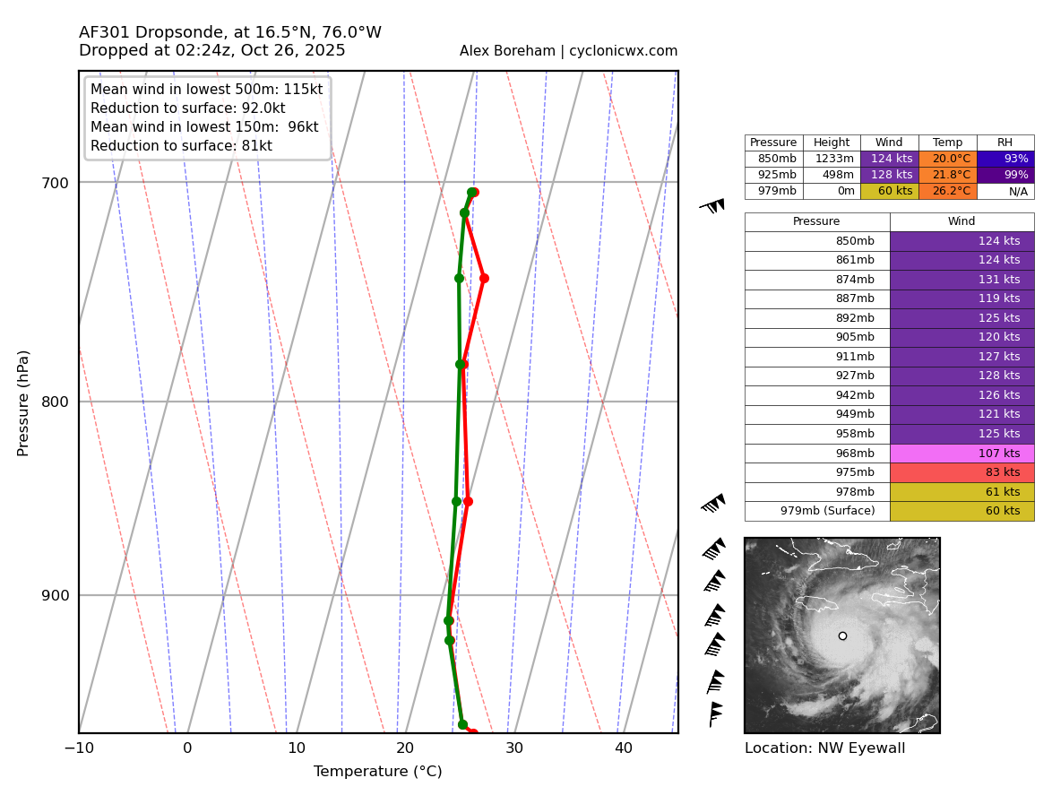
Dropsonde got ~80knots at the surface and 972mb. So Probably 90mph next advisory should it happen right now
Stormsfury
Member
100 mph, 971mb ... there are two RECONs simultaneously in stormDropsonde got ~80knots at the surface and 972mb. So Probably 90mph next advisory should it happen right now
MRKEVIN7575
Member
I guess the good news is it goes out to sea and not hit east coast
Oh boy she going full  .
. 
. IR still definitely improving, latest pass has extrapolated pressure down to ~968mbs.
Brent
Member
IR still definitely improving, latest pass has extrapolated pressure down to ~968mbs.
Yeah I think we're in a show by tomorrow. It needed to start moving which it has today
Stormsfury
Member
Ladies and gentleman, Melissa looks like its on the verge of or has reached Cat 3 status.

Latest dropsonde has 106 kt. 
Cat 4 winds starting to show up way up in the atmosphere.
Ladies and gentleman, Melissa looks like its on the verge of or has reached Cat 3 status.
View attachment 175675
Much higher temp spike in eye compared to the last pass as well.
 Yeah, that joker is cranking.
Brent
Member
...NOAA AND AIR FORCE RESERVE HURRICANE HUNTER AIRCRAFT REPORT
THAT MELISSA IS NOW A MAJOR HURRICANE..
Here she goes
Not sure I've seen this before
Key Messages:
1. Jamaica: Seek shelter now.
THAT MELISSA IS NOW A MAJOR HURRICANE..
Here she goes
Not sure I've seen this before
Key Messages:
1. Jamaica: Seek shelter now.
That’s the most chilling message I’ve seen....NOAA AND AIR FORCE RESERVE HURRICANE HUNTER AIRCRAFT REPORT
THAT MELISSA IS NOW A MAJOR HURRICANE..
Here she goes
Not sure I've seen this before
Key Messages:
1. Jamaica: Seek shelter now.
“Seek shelter now and stay inside for several days” we may never see messaging like this again
Holy ****
Sheesh
This might be sub 950mb by sunrise

Dropped 8mb in about ~1 hour just now. Not sure we’ll get pass before the 2am advisory