Drizzle Snizzle
Member
I ended up with 2.50” of rain, way more than expected. 5.50” for the month.
 . If I lived there.. that’s my sign .. I’m moving!!
hrrr has stayed decently excited, but it seems to have been pushing things back a bit. now not really spinning much till 6-10pmBe interesting to see if anything can fire behind the departing line. Even if it does I'm not sure it can get sufficient depth to have a lot of severe
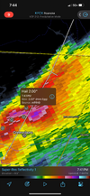
Drive by. TONS of power lines down, some shingles in tree tops, one house lost half the side of the structure. Short path but looks like a touchdown based on velocity last night.Paulding county
New hope near riverwood drive and east Paulding major damage.
Tornado will end up verifying here once the survey is done.
There was a bunch of damage up west Cobb on the way to church this morning probably from the same one. Mars Hill was closed from Due West south a few miles.Drive by. TONS of power lines down, some shingles in tree tops, one house lost half the side of the structure. Short path but looks like a touchdown based on velocity last night.
Probably EF-1+ dmg.
Would be nice. Only .03” here.Be interesting to see if anything can fire behind the departing line. Even if it does I'm not sure it can get sufficient depth to have a lot of severe
I was close to that area when it hit last night. Heard the sirens going off but didn't realize it was on the ground. Luckily my friend had a basement otherwise we wouldn't of gone there.There was a bunch of damage up west Cobb on the way to church this morning probably from the same one. Mars Hill was closed from Due West south a few miles.

OUCHWow... That's almost an ef5View attachment 171960
Wow... That's almost an ef5View attachment 171960


I have watched NWS radar form many years and have never seen purple over MBY so not sure what that means? But yea, assume something intense.Some pretty strong storms headed this way. The worst may miss me to the S and E, though. That storm going through downtown Greensboro looks intense!!! Meanwhile, the airport looks like it may have missed that cell altogether!

Likely hail, I think, and looks like some big hail based on that mPING posted above.I have watched NWS radar form many years and have never seen purple over MBY so not sure what that means? But yea, assume something intense.View attachment 171964
Didn't expect that.3" of rain thus far and another tornado watch just issued, I believe this is a first for me. 2 watches in one day with that much rain in-between
View attachment 171962
There’s only been two EF4’s in recorded history ?

That’s like someone on Facebook posted a “picture” of last nights Dallas, GA EF-1 tornado but the picture really was from a tornado in Oklahoma in like 2003 or something stupid. People just trying to get clicksAnybody see the FB post of the guy around Easley showing what he claimed was double Funnel Clouds? People will post and say anything for views and people will believe it
Yep his security camera captured it, But you can tell it's not Funnel clouds especially twin. There was no rotation at all in the video. The upstate had no Rotation in those storms last night or there would have been a warningThat’s like someone on Facebook posted a “picture” of last nights Dallas, GA EF-1 tornado but the picture really was from a tornado in Oklahoma in like 2003 or something stupid. People just trying to get clicks