• Hello, please take a minute to check out our awesome content, contributed by the wonderful members of our community. We hope you'll add your own thoughts and opinions by making a free account!

Tropical Major Hurricane Isaias

Hurricane Isaias Tropical Cyclone Update
NWS National Hurricane Center Miami FL AL092026
900 PM CDT Fri Oct 09 2026

...LIFE-THREATENING STORM SURGE IMPACTING THE GULF COAST AS
DANGEROUS HURRICANE CONDITIONS AND FLASH FLOODING SPREAD INLAND...
...900 PM CDT POSITION UPDATE...

NWS Doppler Radar data and surface observations indicate that
Hurricane Isaias now has maximum sustained winds of 85 mph (160
km/h) and an estimated minimum central pressure of 978 mb (28.88
inches).


A NOAA National Ocean Service station in Panama City Beach, Florida,
recently reported a wind gust to 83 mph (134 km/h) and a sustained
wind of 72 mph (116 km/h).

This will be the final hourly position update for Isaias. The next
full forecast advisory for Isaias will be issued at 1000 PM CDT
(0300 UTC).

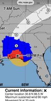
SUMMARY OF 900 PM CDT...0200 UTC...INFORMATION
----------------------------------------------
LOCATION...30.5N 86.4W
ABOUT 50 MI...80 KM E OF PENSACOLA FLORIDA
ABOUT 50 MI...80 KM WNW OF PANAMA CITY FLORIDA
MAXIMUM SUSTAINED WINDS...85 MPH...160 KM/H
PRESENT MOVEMENT...N OR 10 DEGREES AT 19 MPH...31 KM/H
MINIMUM CENTRAL PRESSURE...978 MB...28.88 INCHES

$$
Forecaster Mahoney/Camposano/Reinhart/Cangialosi
 
Hurricane Isaias Tropical Cyclone Update
NWS National Hurricane Center Miami FL AL092026
900 PM CDT Fri Oct 09 2026

...LIFE-THREATENING STORM SURGE IMPACTING THE GULF COAST AS
DANGEROUS HURRICANE CONDITIONS AND FLASH FLOODING SPREAD INLAND...
...900 PM CDT POSITION UPDATE...

NWS Doppler Radar data and surface observations indicate that
Hurricane Isaias now has maximum sustained winds of 85 mph (160
km/h) and an estimated minimum central pressure of 978 mb (28.88
inches).


A NOAA National Ocean Service station in Panama City Beach, Florida,
recently reported a wind gust to 83 mph (134 km/h) and a sustained
wind of 72 mph (116 km/h).

This will be the final hourly position update for Isaias. The next
full forecast advisory for Isaias will be issued at 1000 PM CDT
(0300 UTC).

SUMMARY OF 900 PM CDT...0200 UTC...INFORMATION
----------------------------------------------
LOCATION...30.5N 86.4W
ABOUT 50 MI...80 KM E OF PENSACOLA FLORIDA
ABOUT 50 MI...80 KM WNW OF PANAMA CITY FLORIDA
MAXIMUM SUSTAINED WINDS...85 MPH...160 KM/H
PRESENT MOVEMENT...N OR 10 DEGREES AT 19 MPH...31 KM/H
MINIMUM CENTRAL PRESSURE...978 MB...28.88 INCHES

$$
Forecaster Mahoney/Camposano/Reinhart/Cangialosi
Lowest pressure at Destin so far is 984mb
 
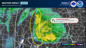
FROM NWS MOBILE

Still getting extreme high winds on the edge of the precip shield from NW Florida (ongoing still), north across Monroe, Escambia, Wilcox and Conecuh counties. This continues to move north with the circulation center. Winds of 80-100mph can be expected with widespread wind damage/power outages expected to continue.Capture.PNG
 
DCT_SPECIAL8_1280x720.jpg
 
Lowest pressure at Destin so far is 984mb

Oops, I made a small mistake. Lowest Destin hourly pressure technically closer to 985 mb (my bad in my earlier post saying 984 mb, to which I just added an edit to clarify). It doesn’t change your important point. Here are the last 2 hourlies, which surround the 8:30PM CDT landfall:

It looks like it came in just E of Destin when it landfalled at 8:30PM CDT (per NHC) per these hourlies’ wind directions:

8PM CDT DESTIN LGT RAIN 71 70 96 NE39G67 29.08 FOG
9PM CDT DESTIN CLOUDY 72 71 97 N26G51 29.11 FOG

So, Destin’s lowest hourly SLP was 985 mb, but lowest overall there likely close to 8:30PM, which is unknown as of now, and lowest landfalling pressure anywhere very likely even lower than Destin’s lowest since center went just to Destin’s east (~8:30PM CDT).
 
Last edited:
Oops, I made a small mistake. Lowest Destin hourly pressure technically closer to 985 mb (my bad in my earlier post saying 984 mb, to which I just added an edit to clarify). It doesn’t change your important point. Here are the last 2 hourlies, which surround the 8:30PM CDT landfall:

It looks like it came in just E of Destin when it landfalled at 8:30PM CDT (per NHC) per these hourlies’ wind directions:

8PM CDT DESTIN LGT RAIN 71 70 96 NE39G67 29.08 FOG
9PM CDT DESTIN CLOUDY 72 71 97 N26G51 29.11 FOG

So, Destin’s lowest hourly SLP was 985 mb, but lowest overall there likely close to 8:30PM, which is unknown as of now, and lowest landfalling pressure anywhere very likely even lower than Destin’s lowest since center went just to Destin’s east (~8:30PM CDT).
The rapidly degrading IR presentation, the almost 20mb increase before the planes departed all lead me to believe the pressures were rapidly rising. It's clear the winds stayed up and likely didn't have time to weaken as fast as the pressure rises would suggest.
 
Yeah with these eastward shifts with the track, not sure if these Wind Advisory’s and Flood Watch will hold for long back here around Memphis. Time will tell.
 
NWS is now warning of an increasing potential for landslides and rockslides across parts of the mountains, particularly near the Blue Ridge Escarpment and the southeast-facing slopes of the Balsam and Black Mountains.
I keep wondering if it’s a good thing that things have been dryer. Things were pretty saturated with Helene.
 
The rapidly degrading IR presentation, the almost 20mb increase before the planes departed all lead me to believe the pressures were rapidly rising. It's clear the winds stayed up and likely didn't have time to weaken as fast as the pressure rises would suggest.

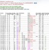
I just got more details that will help:

-Lowest Destin SLP was at 8:20PM CDT per this link at ~982 mb (28.99” altimeter setting):

IMG_2873.jpeg


-Center came ashore E of Destin (since they had NE to N winds just before/just after landfall)

-Center came ashore W of Miramar Beach based on Cantore reporting S winds off the Gulf as the center passed.

-There are 8 miles between those locations. So, the best rough estimate is that landfall was 4 miles E of Destin.

-So how much lower do you think the SLP would be at 4 miles to the E of Destin’s 982 mb?
 
I just got more details that will help:

-Lowest Destin SLP was at 8:20PM CDT per this link at ~982 mb (28.99” altimeter setting):

View attachment 198723


-Center came ashore E of Destin (since they had NE to N winds just before/just after landfall)

-Center came ashore W of Miramar Beach based on Cantore reporting S winds off the Gulf as the center passed.

-There are 8 miles between those locations. So, the best rough estimate is that landfall was 4 miles E of Destin.

-So how much lower do you think the SLP would be at 4 miles to the E of Destin’s 982 mb?
That's a tough one. Some storms IE Patricia I remember Josh reporting 1mb every mile he got closer to the center. Not sure that's a standard number so it would be a wild guess with a rapidly weakening storm.


I think 980 would be a reasonable
 
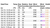
Poking around Georgia obs before hitting the rack. The highest gust I found in Georgia so far is 48 mph in Columbus.

I'd expect similar weather around ATL by morning as the wind field expands with further transition to extratropical.
Looks like Macon got to 51mph around the time of your postIMG_3960.jpeg
 
Back
Top