
Even our Mets are watching this! 
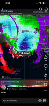



Explains why Penscola and Fort Walton Beach getting blasted with windsPer Dr. Knabb: The strongest winds are currently on the NW-W side of the center due to how the strong southerly wind shear is interacting. Interesting.


Tonight:
Conditions will rapidly deteriorate tonight. Widespread
precipitation will be present by early evening, with the
strongest winds occurring during the evening hours across the
southern half of the area. The peak wind impacts will materialize
after landfall and continue into Saturday morning. The sustained
tropical storm force wind probabilities may be conservative given
the pressure gradient with high pressure to the east, and do not
fully reflect the potential for damaging wind gusts. An
inversion/stable layer will remain in place north of a warm front
closer to the coast, though forecast soundings continue to
indicate significant winds near the surface. Highest sustained
winds are expected across southern counties, with higher wind
gusts of 50 to 60+ mph extending further north. Given the
anticipated impacts of widespread downed trees and power outages,
wind-related have been issued. With the transition to an extratropical
system, determining the exact boundary to transition from tropical
to non-tropical wind products remains challenging. Generally, I-20
in the east and I-22 serve as the approximate cutoff between
tropical storm and high wind warnings. There is a possibility
after the system loses its tropical status, additional wind
advisories may be needed.

| Humidity | 91% |
| Wind Speed | NE 44 G 92 mph |
| Barometer | 29.24 in (990.3 mb) |
| Dewpoint | 64°F (18°C) |
| Visibility | 2.50 mi |
| Last update | 9 Oct 6:53 pm CDT |


Consistent with a cat 2 landfall.Almost a 100 mph gust at Pensacola ....highest one so far I have seen so far.
Humidity 91% Wind Speed NE 44 G 92 mph Barometer 29.24 in (990.3 mb) Dewpoint 64°F (18°C) Visibility 2.50 mi Last update 9 Oct 6:53 pm CDT


 forecast.weather.gov
The 972mb was over 2 hours ago I'd imagine at the rate it was filling that landfall will be closer to 978 or higher.
Still some serious wind in that western side
Where did they get that 971 from? Are they going with the last vdm or do.they have a different source?I just saw this as of 9PM EDT from NHC:
Hurricane Isaias Tropical Cyclone Update
NWS National Hurricane Center Miami FL AL092026
800 PM CDT Fri Oct 09 2026
...WATER LEVELS RISING RAPIDLY ALONG THE COAST AS DANGEROUS
HURRICANE CONDITIONS AND LIFE-THREATENING FLASH FLOODING SPREAD
INLAND...
...800 PM CDT POSITION UPDATE...
A NOAA National Ocean Service water level gauge in Panama City
Beach, Florida, recently reported a water level of 5.4 feet above
mean higher high water, which is an approximation of inundation in
that area.
A wind gust to 102 mph (164 km/h) with a sustained wind of 62 mph
(100 km/h) was recently reported at Pensacola City Hall.
SUMMARY OF 800 PM CDT...0100 UTC...INFORMATION
----------------------------------------------
LOCATION...30.2N 86.5W
ABOUT 50 MI...80 KM ESE OF PENSACOLA FLORIDA
ABOUT 50 MI...80 KM W OF PANAMA CITY FLORIDA
MAXIMUM SUSTAINED WINDS...105 MPH...165 KM/H
PRESENT MOVEMENT...N OR 10 DEGREES AT 19 MPH...31 KM/H
MINIMUM CENTRAL PRESSURE...971 MB...28.67 INCHES
$$
Forecaster Mahoney/Camposano/Reinhart/Cangialosi
Where did they get that 971 from? Are they going with the last vdm or do.they have a different source?
I'm sure there will be a definite pressure at landfall locationGood question as I don’t know.
Check this out as of 9PM at Destin with center just offshore likely just to their SSE based on NE wind:
DESTIN LGT RAIN 71 70 96 NE39G67 29.08 FOG
That’s 984 mb.

