• Hello, please take a minute to check out our awesome content, contributed by the wonderful members of our community. We hope you'll add your own thoughts and opinions by making a free account!

Tropical Major Hurricane Isaias

Tropical Storm Isaias Discussion Number 6
NWS National Hurricane Center Miami FL AL092026
1000 PM CDT Wed Oct 07 2026

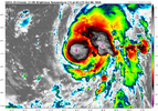
Aircraft data and satellite trends indicate Isaias has continued
intensifying this evening. The center of the tropical cyclone is
embedded underneath a small central dense overcast with very cold
tops associated with deep convection. Upper-level outflow is
observed in all quadrants, though it remains somewhat restricted to
the southwest due to moderate vertical wind shear. Data from the Air
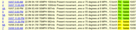
Force Hurricane Hunters indicates the central pressure has fallen to
988 mb, and on the last fix they reported a circular eyewall open to
the southwest. Based on these developments, the initial intensity is
raised to 60 kt.

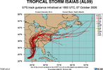
Aircraft fixes indicate the center is still moving toward the
east-northeast (070/8 kt). The system is expected to accelerate
northeastward tomorrow and then northward on Friday within the flow
between a deepening trough over the south-central United States and
a strengthening subtropical ridge over the western Atlantic. This
steering pattern is forecast to bring the center of Isaias to the
northern Gulf Coast late Friday night into early Saturday. There
were no major changes to the guidance suite, with the AI-based
models generally faster and farther right than the physics-based
models. The NHC forecast continues to lean more heavily on the
better-performing corrected consensus (HCCA) and Google DeepMind
(GDMI) aids, remaining on the faster and right side of the guidance
envelope. The inland track at 60-72 h was shifted westward as more
models now show Isaias becoming captured by the cutoff low over the
southeastern United States.

Continued strengthening is expected during the next day or so as
Isaias moves over very warm waters in a moist environment with
moderate vertical wind shear. Given its small size and formative
inner core, rapid intensification is a distinct possibility, and the
NHC forecast lies on the high end of the intensity guidance. The
shear is predicted to markedly increase on Friday while Isaias
approaches the northern Gulf Coast, but the system is expected to
remain a dangerous hurricane through landfall. Gusty winds are
expected well inland after landfall given the anticipated expansion
of the wind field and fast forward speed of the storm.

Hurricane, Storm Surge, and Tropical Storm Warnings have been
issued with this advisory for portions of the northern Gulf Coast.
 
...ISAIAS BECOMES A HURRICANE...

Dropsonde data from an Air Force Reserve hurricane hunter aircraft
indicates that Isaias has become a hurricane, with maximum sustained
winds of 75 mph (120 km/h) with higher gusts. The minimum central
pressure measured from another dropsonde launched in the eye was
982 mb (29.00 inches).
Who knew that the first hurricane of the season will be a I-storm.
 
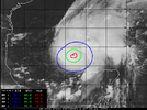
The change on IR over the last few hours is drastic. This being a MH in twelve hours wouldn't surprise me.
I would agree with that. I am curious to see how strong this one can get before the shear takes over for sure. I wonder if it can stay "east" enough long enough to maintain a cat 2 at landfall.
 
I would agree with that. I am curious to see how strong this one can get before the shear takes over for sure. I wonder if it can stay "east" enough long enough to maintain a cat 2 at landfall.
Something to consider regarding the shear. The storm is and will be moving with the direction of the mid-level shear and will get upper-level enhancement from divergent flow aloft as it approaches the coast. There is a great deal of dry air to the west, though. Tricky intensity forecast for sure.
 
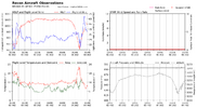
Underwelming pass so far wind wise, but pretty substantial pull north of the COC.

Edit: But huge spike in temp. My guess is the LLC and the MLC are still slightly disjointed and preventing rapid strengthening. IR kind of shows this.
 
Underwelming pass so far wind wise, but pretty substantial pull north of the COC.

Edit: But huge spike in temp. My guess is the LLC and the MLC are still slightly disjointed and preventing rapid strengthening. IR kind of shows this.
Unless TT is running slowly, it hasn't reached the core yet. No?
 
Winds catching up.
635
URNT15 KNHC 080445
AF301 0509A ISAIAS HDOB 42 20261008
043630 2311N 09141W 6947 03065 9885 +119 +107 105029 030 /// /// 03
043700 2312N 09140W 6940 03079 9901 +110 //// 116033 037 /// /// 05
043730 2314N 09139W 6939 03087 9912 +109 +102 129029 031 /// /// 03
043800 2315N 09138W 6946 03081 9921 +106 +095 135033 033 /// /// 03
043830 2316N 09137W 6933 03101 9928 +101 +100 143038 041 /// /// 03
043900 2317N 09135W 6934 03107 9941 +096 //// 144043 045 /// /// 05
043930 2318N 09134W 6942 03098 9950 +090 //// 149053 056 /// /// 05
044000 2318N 09132W 6962 03077 9948 +093 //// 157053 055 /// /// 05
044030 2319N 09130W 6929 03117 9949 +097 //// 156055 057 /// /// 05
044100 2321N 09129W 6954 03092 9954 +095 //// 155062 069 /// /// 05
044130 2322N 09128W 6938 03118 9976 +080 //// 137057 070 /// /// 05
044200 2324N 09128W 6949 03105 //// +072 //// 135052 056 /// /// 05
044230 2326N 09127W 6935 03131 //// +070 //// 134047 052 /// /// 05
044300 2327N 09126W 6949 03117 //// +067 //// 129044 049 /// /// 05
044330 2329N 09125W 6938 03134 //// +063 //// 124042 043 /// /// 05
044400 2331N 09125W 6940 03137 0026 +064 //// 126042 043 /// /// 05
044430 2333N 09125W 6938 03144 0024 +069 //// 125042 044 /// /// 05
044500 2335N 09126W 6946 03137 0018 +078 //// 122039 043 /// /// 05
044530 2337N 09126W 6945 03137 0008 +083 //// 117038 040 /// /// 05
044600 2338N 09126W 6955 03132 //// +076 //// 114034 040 /// /// 05
 
Something to consider regarding the shear. The storm is and will be moving with the direction of the mid-level shear and will get upper-level enhancement from divergent flow aloft as it approaches the coast. There is a great deal of dry air to the west, though. Tricky intensity forecast for sure.

I agree. I don't envy anyone trying to forecast intensity here. I mean it's always a mess(track is the easy part...) if we remember past forecasts but there's a wide range of possibilities

Lili went from a strong Cat 4 to a weakening rapidly Cat 1 in the final 12 hours before landfall(at the end of a 3 year streak of no hurricane landfalls...) but there's also the other extreme of Michael which in both cases nobody saw coming

Like anyone who thinks they know what landfall intensity will be is kidding themselves
 
Last edited:
bd0.gif


rbtop-animated.gif
 
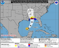
...NOAA HURRICANE HUNTERS INDICATE THAT ISAIAS CONTINUES TO INTENSIFY... ...PREPARATIONS TO PROTECT LIFE AND PROPERTY FROM STORM SURGE AND DAMAGING WINDS ALONG THE WARNING AREA OF THE GULF COAST SHOULD BE RUSHED TO COMPLETION TODAY...

4:00 AM CDT Thu Oct 08
Location: 23.3°N 91.2°W
Moving: ENE at 9 mph
Min pressure: 979 mb
Max sustained: 80 mph
 
FFC this AM:

LONG TERM...
(Friday night through Wednesday)
Issued at 239 AM EDT Thu Oct 8 2026

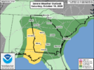
The focus of the long-term period will be Hurricane Isaias and its
potential impacts on the forecast area. The latest forecast cone
from NHC progs landfall somewhere between the Mississippi coast and
western portion of the Florida Panhandle. This positions north and
central Georgia on the eastern side of the center of Isaias, where
strong winds, flooding rain, and tornadoes will all be on the table.

Wind Threat: High pressure will remain in place on Friday, having
built in over the Appalachians on Thursday and been reinforced with
cold air damming (the "wedge"). A tightening pressure gradient is
expected at the surface across Georgia as Isaias moves northward and
pushes up against the high pressure area. Due to this tightened
gradient, the area of strong winds is forecast to be larger on the
east side of Isaias. As a result, at least some period of sustained
winds of 15-25 mph and gusts of 25-35 mph can be expected across
north and central Georgia. Additionally, a developing upper-level
low will be moving eastward across the Southeast Friday into
Saturday. This will likely accelerate the extra-tropical transition
(ET) of Isaias and may bring potential for an initial increase in
winds in the immediate hours after Isaias has begun its ET. There is
also the potential for the development of a "sting jet" -- an
acceleration of descending air that brings extreme localized winds.
Some form of wind-related Watch issuance is very likely in the next
24 hours or so.

Flooding Rain Threat: Given strong tropical moisture advection as
Isaias moves inland, widespread rainfall is expected early Saturday
morning through early Sunday morning. The convective rainbands from
Isaias will be where the most efficient rainfall will be focused.
That said, it is futile to try to pin down where exactly the
heaviest rain will occur, so residents anywhere in Georgia should
prepare for the possibility of localized flash flooding and/or river
flooding, should they find themselves under persistent rainbands.
Our current forecast has widespread 2 to 3 inches through the
weekend, backed by most of the ensemble guidance. Would not be
surprised to see hi-res guidance painting bullseyes/swaths of
greater amounts over the coming days as they try to resolve the
rainbands.

Tornado Threat: The conceptual model of tropical storms and
hurricanes holds that the front right quadrant of these systems have
the greatest potential for tornadoes. Given that the center of
Isaias will very likely track to the west of Georgia, tornadoes will
be a possibility across parts of the forecast area -- especially
along the wedge boundary and outside of the cooler, stable wedge
airmass.
 
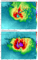
Sattelte imagery is a bit ragged ATM. Recon is just arriving. I doubt it's done very much overnight.

Yeah never a good sign that its hard to tell where the exact center is on IR and the window to go nuts is closing, Cat 3 seems less and less likely at this point, it would have to organize a small tight center like right now to pull it off. I suspect this will be one of those open on one side eyewalls with a fairly small area of strongest winds on the east side somewhere when it comes in, the dry air and shear only get worse tomorrow.

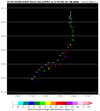
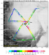
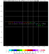
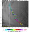
Latest recon is meh on winds, this is the NW eyewall

1791461764201.png
 
Sattelte imagery is a bit ragged ATM. Recon is just arriving. I doubt it's done very much overnight.

One thing is clear though, the joker has expanded alot. Huge area of flight level 65+knt winds SE of the center and it will only get bigger.
 
Looking at the WV, the outflow looks like its starting to improve on the western side of the system. I think the next 18 hours is its best chance to strengthen. I also see the dry air push moving east over southern Texas toward the western Gulf. There also seems to be a small Upper Level Low south of Cuba.
 
Back
Top