GFS looks very wet through the whole run! Let’s keep that going as long as we can! Summer will be dry soon enough!
-
Hello, please take a minute to check out our awesome content, contributed by the wonderful members of our community. We hope you'll add your own thoughts and opinions by making a free account!
You are using an out of date browser. It may not display this or other websites correctly.
You should upgrade or use an alternative browser.
You should upgrade or use an alternative browser.
Pattern Magnificent March
- Thread starter GaWx
- Start date
All of the Mets in B'ham have already mentioned a "vigorous system that will need to be watched for severe weather" during this time period, and now we have a thread.
From the last line of the long term section from the most recent BMX AFD:
"Confidence just isn`t there with how the parameters
are lining up to mention any severe threat for Thursday/Friday right
now."
Why was a thread made?
Last edited:
pcbjr
Member
You will have to ask DadofJax. Obviously some mets and others think the system needs to be watched. No one I read said there would be severe, just a vigorous storm system that should be watched this time of year. And with the map above by pcbjr, as strong cold front is modeled to be coming through at some point after the upper 70s and near 80 late next week.From the last line of the long term section from the most recent BMX AFD:
"Confidence just isn`t there with how the parameters
are lining up to mention any severe threat for Thursday/Friday right
now."
Why was a thread made?
Starting to think it may be May before things start to bloom here.
it's 90 degrees in Southwest Kansas !
Don’t care what happens in the weather world, as long as Duke loses tonight, all is right in the world! I think I’ll road trip to Roxboro tomorrow!
dsaur
Member
That's one of those abacus words, right? I know I thoroughly enjoyed the wind and cold the other day. Stayed out in it all day, just storing up the memories for later in the doldrums of summer.March has easily earned its "magnificitness", just the opposite of the February disappointment.
Brent
Member
it's 90 degrees in Southwest Kansas !
hah, 90 before Dallas
didn't even get close to 80 here today due to unexpected clouds. Tomorrow supposed to approach 90 but we'll see how well that goes
hit the 90s in the Amarillo area... literally the only place I'd ever move to in the state of Texas..
Webberweather53
Meteorologist
We have the right background state to take advantage of a favorable synoptic pattern for severe weather, we just need a trigger to set off this powder keg and who knows when/if we'll get that. Still gives me the chills we're following 2011 this closely even though obviously the inter-event variability is so large it doesn't necessarily effectively downscale the way you think it would but that's besides the point. A hot and dry high plains adjacent to a warmer than normal Gulf of Mexico and relatively beign/wetter than average central MS valley is a recipe for big trouble if other pieces cooperate. There's a very good reason we had a dry line penetrate all the way into AL, MS, and TN last week, this EML is insane thanks to the drought over west Texas, Oklahoma, and Kansas and the rest of the southwestern US.


Current US drought monitor.


Current US drought monitor.


Brent
Member
hit the 90s in the Amarillo area... literally the only place I'd ever move to in the state of Texas..
been a rough few months there... extreme drought and basically no snow(in the one place in the state that usually sees a ton). At least we've had plenty of rain
I like small to mid sized cities, where there's at least a year to year chance of seeing snow.. no idea how the economy is there. Probably not that good. Ideally I'd move to the front range, Pueblo or Colorado Springs.
Snowflowxxl
Member
Looks like parts of the southeast could be dealing with Severe weather again next Wed/Thurs
cd2play
Member
Imagine Dragons: Thunder, feel the thunder; lightning and the thunderLooks like parts of the southeast could be dealing with Severe weather again next Wed/Thurs
Webberweather53
Meteorologist
The Euro and GFS look mighty interesting for NC and SC on Friday wrt severe weather, pretty decent looking synoptic setup w/ a low passing to our NW over the apps, nice deep layer veering and shear, convective looking precipitation field and there's some marginal CAPE to work with (which will likely be a limiting factor)
Brent
Member
89 lovely degrees here today, tied the record from 1929 
Wow. I was over 50 degrees colder than you.89 lovely degrees here today, tied the record from 1929
Brent
Member
Wow. I was over 50 degrees colder than you.
also first time I'm hearing the spring bugs tonight and the news reported the first mosquito sightings earlier
I think its time for you to start planning on a move northalso first time I'm hearing the spring bugs tonight and the news reported the first mosquito sightings earlier
Brent
Member
I think its time for you to start planning on a move north
lol I always have plans but I actually don't hate this little corner of Dallas which is basically a moderate size town where I live and work is so close so its complicated
Definitely something that will not happen soon
Last edited:
gawxnative
Member
About the stongest of a Spring Wedge that I can remember.. 41 for me here now .meanwhile FFC is 68.
temps doing some crazy things tonight here in Chattanooga... went from 57 around 9 pm to 64 at 2 am, then dropped to 50 currently... guess we're getting on the other side of the Low now.
While Hunter AAFB is as of 10 AM still at 64, KSAV (airport that is only 8 miles from Hunter) has dropped in one hour due to a wind shift from light W winds to moderate N winds from 64 to 52! Can you say well defined wedge front?
gawxnative
Member
And so far a daytime recovery up to 43...lolAbout the stongest of a Spring Wedge that I can remember.. 41 for me here now .meanwhile FFC is 68.
It's 48 at the GA/AL border west of ATL and 77 in Birmingham less than 100 miles away !
EastAtlwx
Meteorologist
This wedge is incredible...
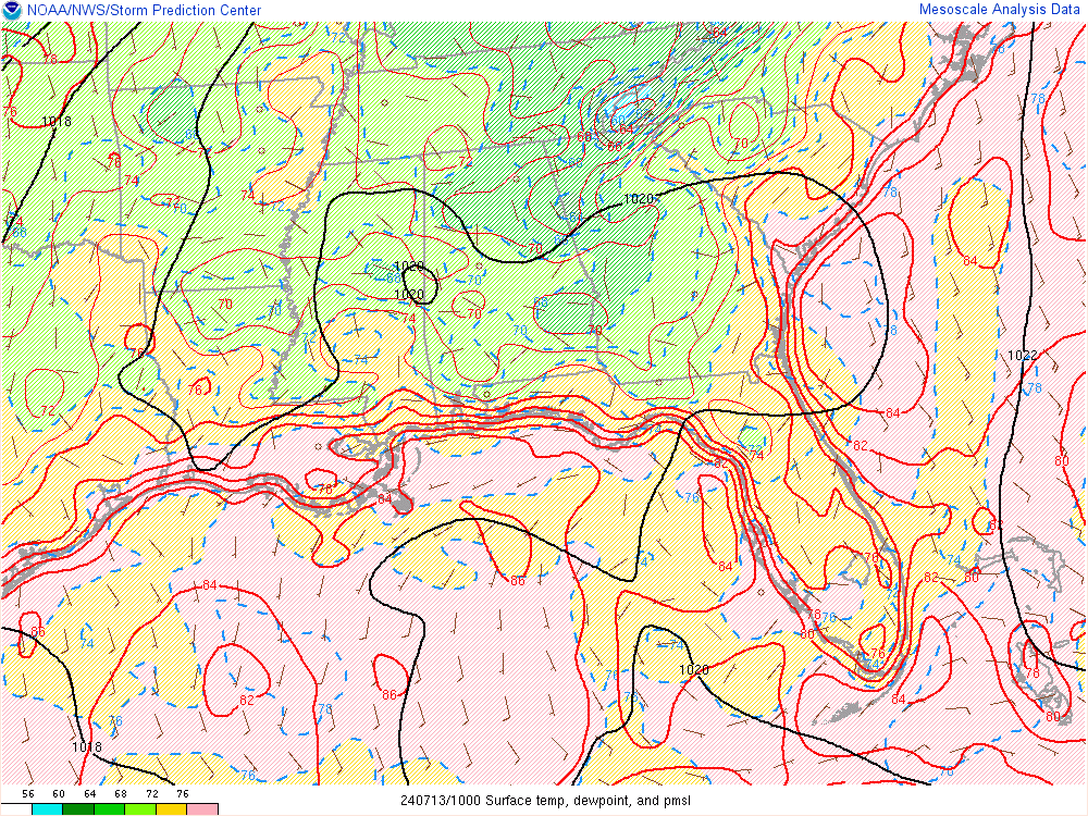
and surface diagnosis two hours ago..
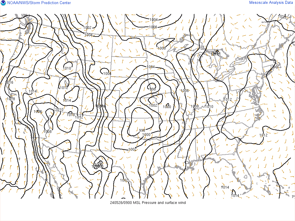

and surface diagnosis two hours ago..

Indeed. We’ve got upper 40’s all the way into South Georgia at 3pmThis wedge is incredible...
and surface diagnosis two hours ago..

dsaur
Member
Where were all these cads back when it was cold?? It was cold, right? So long ago..... Anyway cads out in front on Goofy...it's all about timing in the south...whether is off by 6 hours or two months...it's still off down hereAbout the stongest of a Spring Wedge that I can remember.. 41 for me here now .meanwhile FFC is 68.
This is easily one of the most incredible/memorable spring wedges for me. I won't soon forget this one. While practically everyone else I know here is complaining about it being cold, I'm loving every minute of it and expect to be walking out in it in a few hours.
The wind has been quite brisk at times as well... this morning before daybreak I was having gusts 30-35... just cuts right through you for sure!
Storm5
Member
Currently 85 degrees here in Baton Rouge . I went from a snow storm in Maryland to a damn furnace here in LA and I love it
Sent from my SM-J327VPP using Tapatalk
Sent from my SM-J327VPP using Tapatalk
Greensboro is running almost 6 degrees Below Normal on temps for March 2018.
And has recorded 5 inches of total snow for March 2018. Pretty amazing.
And has recorded 5 inches of total snow for March 2018. Pretty amazing.
Brent
Member
Currently 85 degrees here in Baton Rouge . I went from a snow storm in Maryland to a damn furnace here in LA and I love it
Sent from my SM-J327VPP using Tapatalk
You're welcome lol
Geez...old man Winter is angry!! This is night 3 of gusty winds just slamming into the house. Certainly doesn’t help that my portion of the neighborhood is perched on a large hill either. It’s been gusting 25-30 most the evening and really hasn’t let up much. One hell of a wedge. 44 this hour but feels colder with the showers coming down at times.
Sent from my iPhone using Tapatalk
Sent from my iPhone using Tapatalk
packfan98
Moderator
Why is it 38 degrees here at noon????
With some light rain earlier what gives?!Why is it 38 degrees here at noon????
Sent from my SM-G920V using Tapatalk
Gotta love waa over top a residual wedge locking in a cold ass dayWith some light rain earlier what gives?!
Sent from my SM-G920V using Tapatalk
Sent from my SM-G955U using Tapatalk

