NCHighCountryWX
Member
- Joined
- Dec 28, 2016
- Messages
- 700
- Reaction score
- 1,921
Excellent presentation from a real meteorologist
Is it an increase or is it just the 18zGoogle’s really digging its heels in for NC. Looks like a QPF increase over 12z
It will be moving some by tonight, not like last week. But you can sense it, why you been seeing more coastal enhancement today. If this thing would hug the coastline up to the bottom of the delmarva,tidewater. Be historic in enc.In ran away during the last storm. Moved 100 miles north every model run for the last 72 hours
6z 18z good/ 12z 0z badIs it an increase or is it just the 18z


It's amazing what a real block will do. We're so used to not seeing one, that things seem to behave strangely to us when one is actually present.I dont think this is ticking north…it’s remarkable how stubborn that 50/50 is. It just won’t move out…never seen anything like it. Every single winter storm we’ve ever had that has lifted out quicker than modeled as we approached go time. But not this time…
View attachment 191465View attachment 191466
Never thought I’d see the day people would cheer for the 50/50 to move out so they could get snowIt's amazing what a real block will do. We're so used to not seeing one, that things seem to behave strangely to us when one is actually present.
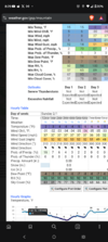
With ratios that’s probably 6-12” for most of NC lol. Pretty insane and something I wasn’t expecting!I just realized though, it got the .5 qpf almost always to Va line. Can you run a trend gif? I can't figure out how to make that happen on SV yet
View attachment 191461
Yep…this?I just realized though, it got the .5 qpf almost always to Va line. Can you run a trend gif? I can't figure out how to make that happen on SV yet
View attachment 191461


Please forgive me. It really fell flat and leveled off after about hour 38. Still going to be a good hit but it looked like it was going toward God tierThis hrrr run is going to be dgex like


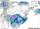
View attachment 191483triangle area that was dry slotted on a couple model runs earlier today, now NC bullseye on 0z HRRR. this is gonna be such an interesting one to see unfold
View attachment 191483triangle area that was dry slotted on a couple model runs earlier today, now NC bullseye on 0z HRRR. this is gonna be such an interesting one to see unfold
Looking more like Low is going to be closer to coastMid level warm front trending NW on the hrrr… does it continue to do so ? It’s a pretty big forcing mechanism for the precipitation. Wonder if it keeps jogging NW View attachment 191480View attachment 191482

This would move the dry slot as well, right? Which side of this do you want to be on?Mid level warm front trending NW on the hrrr… does it continue to do so ? It’s a pretty big forcing mechanism for the precipitation. Wonder if it keeps jogging NW View attachment 191480View attachment 191482

 Sizable jump very early in the NAM run
That dark green line is where the 0 deg C line is located 95% of the time with these - not out in the ocean. Don’t take this one for granted folksMid level warm front trending NW on the hrrr… does it continue to do so ? It’s a pretty big forcing mechanism for the precipitation. Wonder if it keeps jogging NW View attachment 191480View attachment 191482

It basically takes Augusta from 4-5 inch consensus from the globals to less than 1 inch on the HRRRSerious question.... are we buying the HRRR yet? HUGE intrusion of dry air in the southwestern section of this.... basically in south central to southwestern SC... the HRRR is cutting the totals from 5-6 inches on Euro/4-5 on GFS to 0.9 inches on HRRR. That's a huge bust on the globals if so
Could allow time for system to go negative, and slow? 50/50 looks like its Building back into NE areaAnother little tick west on the NAM at 12
View attachment 191485
No doubt, in Georgia, there will be elation and heartbreak mere miles apart. The HRRR was the first model to put the 850MB meso low deform band squarely over MBY and delivered 5". Most have that band further east.This would be so heartbreaking for me. Less than an inch for my backyard while literally 5 miles to my northeast they get a 3-4 inch lollipop.
Can I get a laymen’s term explanation on what that does on either side for this storm?That dark green line is where the 0 deg C line is located 95% of the time with these - not out in the ocean. Don’t take this one for granted folks
View attachment 191488