packfan98
Moderator
Any chance you could do a trend loop? Looks like the sample size wasn't large enough for this model because it for sure doesn't look like it's leading the way. The GFS suite has been locked in for a couple of days.
Any chance you could do a trend loop? Looks like the sample size wasn't large enough for this model because it for sure doesn't look like it's leading the way. The GFS suite has been locked in for a couple of days.
yeah probably, its just really really funny that the GFS was closer than itIirc @bouncycorn said once that the AI models don't always slowly shift but if changes arise, make a big jump and kinda lock in. Something along those lines, anyway, seems Google AI did that. One big adjustment and locked, maybe?
This trend of precip shows a precip max developing over western nc and another in eastern nc. A steadier but slightly less amount over central nc seems reasonable. Hopefully the models continue to latch onto this enhanced look rather than precip maxes handing off to one anotherThe handling of the coastal is intriguing. Rather than the coastal pumping moisture inland it seems we are getting a hybrid setup where the ULL starts to interact with the coastal and enhance the moisture stretching back towards the deepening low. The obvious fail here is if webbers dry slot appears and this is more of a handoff rather than an enhancement.
Need the coastal to form nc/sc border or south. If it forms due east of us it has to go super bomb to wrap all the way back in time before it's too far northThe handling of the coastal is intriguing. Rather than the coastal pumping moisture inland it seems we are getting a hybrid setup where the ULL starts to interact with the coastal and enhance the moisture stretching back towards the deepening low. The obvious fail here is if webbers dry slot appears and this is more of a handoff rather than an enhancement.
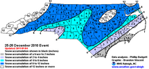
December 2010 was an example of a "hand off". Different setup, whereas Charlotte and southwestward should do better this time, but this drier zone can happen.The handling of the coastal is intriguing. Rather than the coastal pumping moisture inland it seems we are getting a hybrid setup where the ULL starts to interact with the coastal and enhance the moisture stretching back towards the deepening low. The obvious fail here is if webbers dry slot appears and this is more of a handoff rather than an enhancement.
Interesting that the changes doesn’t really effect the coastal path much. I wonder if it will jump today?
Based on? A hunch?Expect continued westward trends with the ULL and expanded qpf fields back into AL/GA. This may continue until verification…time will tell.
Just checking in how is AL/GA looking with more recent runs, do we have a better chance now or about the same?Expect continued westward trends with the ULL and expanded qpf fields back into AL/GA. This may continue until verification…time will tell.
The euro and gfs ai models are showing an initial dry slot over the Sandhills north atm. It backfills but initially is slotted.The handling of the coastal is intriguing. Rather than the coastal pumping moisture inland it seems we are getting a hybrid setup where the ULL starts to interact with the coastal and enhance the moisture stretching back towards the deepening low. The obvious fail here is if webbers dry slot appears and this is more of a handoff rather than an enhancement.
Just checking in how is AL/GA looking with more recent runs, do we have a better chance now or about the same?
I'm fairly certain, unless something changes, you can shift that east and slightly NE about 2-3 rows of counties.December 2010 was an example of a "hand off". Different setup, whereas Charlotte and southwestward should do better this time, but this drier zone can happen.
View attachment 190506
Based on:Based on? A hunch?
When you take the average of huge storms and zeros, like the NWS often does with the uncertainty at this stage, the 'forecast' is sometimes the least likely to happen.NWS must be thinking 3:1 ratios are happening??? lol
I'm sorry, but this is pathetic. It's just a wishcast for less snow essentially. no guidance supports this. Is it their job to mislead the public?
Edit: just saw it's only through 7am Saturday, so nevermind. Haha
yep, been watching that precip divot on the modelsThe handling of the coastal is intriguing. Rather than the coastal pumping moisture inland it seems we are getting a hybrid setup where the ULL starts to interact with the coastal and enhance the moisture stretching back towards the deepening low. The obvious fail here is if webbers dry slot appears and this is more of a handoff rather than an enhancement.
We're still looking good. The AI models are not great for my location over to your place. But the GIS ai did bump up the QPF some for us. Hopefully that can continue at 12z:I'm fairly certain, unless something changes, you can shift that east and slightly NE about 2-3 rows of counties.
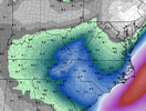
We're still looking good. The AI models are not great for my location over to your place. But the GIS ai did bump up the QPF some for us. Hopefully that can continue at 12z:
View attachment 190512
Honestly, 5-6" would be a win for me.
We're used to it. If the warm nose doesn't get us, the dry slot will.The euro and gfs ai models are showing an initial dry slot over the Sandhills north atm. It backfills but initially is slotted.
Well it's slight but even on the 3 run trend of the NBM you can start to see amounts increase W/SW and the dry slot slowly inch north. Subtle but thereWe're still looking good. The AI models are not great for my location over to your place. But the GIS ai did bump up the QPF some for us. Hopefully that can continue at 12z:
View attachment 190512
Honestly, 5-6" would be a win for me.
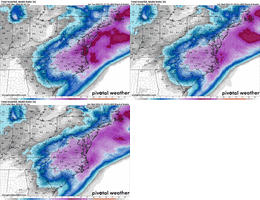
We're still looking good. The AI models are not great for my location over to your place. But the GIS ai did bump up the QPF some for us. Hopefully that can continue at 12z:
Honestly, 5-6" would be a win for me.
And other models as well. We (weather weenies) always focus on the worse models and the worse possible outcome. Which is part of the game.Google looks really good for our location
Sent from my iPhone using Tapatalk
Considering the 0z Canadian had the snow not ending in eastern areas until sat after 0z, the rgem is a big hit for north ga. I hope the 12z run is consistent.6Z RGEM, still snowing over north GA.

This is life along 95/the fall line. It always happens here. There are very few wintry weather events I can remember where MBY wasn't either in a precip hole or along the 10 mile wide razor edge transition of snow/sleet/rain. Or we will get sleet with a light dusting at the end of the event while points 20 miles north/west get all snow. I'm hopeful for a good performer out of this system but also trying to keep expectations realistic.We're used to it. If the warm nose doesn't get us, the dry slot will.
I grew up in Coats so I know all too well! Still a lot to change possibly between now and Sat morn!We're used to it. If the warm nose doesn't get us, the dry slot will.
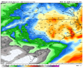
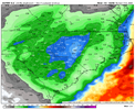
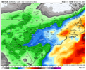
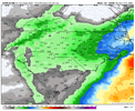
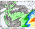
I expect that to drop some more (especially for us) once the GFS comes down to reality.Well it's slight but even on the 3 run trend of the NBM you can start to see amounts increase W/SW and the dry slot slowly inch north. Subtle but there
View attachment 190514
The dry slot (lesser amounts) near our area though looks real on several model outputs now.And other models as well. We (weather weenies) always focus on the worse models and the worse possible outcome. Which is part of the game.
Hopefully this is better
View attachment 187010
Especially since the GFS output is the Low basically stalling/meandering off NC/VA for 12-18 hours. No other model show is getting captured. They show gradual NE movement not a crawlI’d be very wary about the crazy high qpf of the last several GFS over C and E NC. It had 2-4” of qpf for the previous storm in many areas like ATL and much of N GA ended up with only ~0.75”. I’d at least cut the GFS’ in half. Besides we know it is an inferior model in general. Compare the GFS crazy high qpf to the other models and it isn’t really close for the most part:
GFS way out on limb:
View attachment 190515
Euro: way less than GFS
View attachment 190516
CMC: much less than GFS except within 75 miles of coast:
View attachment 190517
ICON: way less than GFS
View attachment 190518
UKMET: way less than others/likely way underdone
View attachment 190519
I’d favor going with the middle ground combo of Euro and Icon as of now for overall qpf amounts and favor the Euro’s C NC for the heaviest at this point.
Probably correct but most of the western piedmont is from the ull, correct? The qpf letdown has been from surface lows. If we can get the neutral to negative tilt to occur, I would expect decent returns.I’d be very wary about the crazy high qpf of the last several GFS over C and E NC. It had 2-4” of qpf for the previous storm in many areas like ATL and much of N GA ended up with only ~0.75”. I’d at least cut the GFS’ in half. Besides we know it is an inferior model in general. Compare the GFS crazy high qpf to the other models and it isn’t really close for the most part:
GFS way out on limb:
View attachment 190515
Euro: way less than GFS
View attachment 190516
CMC: much less than GFS except within 75 miles of coast:
View attachment 190517
ICON: way less than GFS
View attachment 190518
UKMET: way less than others/likely way underdone
View attachment 190519
I’d favor going with the middle ground combo of Euro and Icon as of now for overall qpf amounts and favor the Euro’s C NC for the heaviest at this point.
