NBAcentel
Member
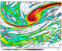
GEFSAI throwing back a .7 QPF finger all the way to Charlotte 
An AI model honking on ULL stuff is extremely impressive. It just means that the short range models will be printing some pretty things here soon.GEFSAI throwing back a .7 QPF finger all the way to Charlotte View attachment 190413
Yeah. Seems with the AI’s, their forecast is revolving heavily around that. Hard to ignore right nowAn AI model honking on ULL stuff is extremely impressive. It just means that the short range models will be printing some pretty things here soon.

UKMET wants to be dr. NO so bad View attachment 190406View attachment 190407


whew, liking this so far


My goodness, yall are on top of this run.Watch the Euro’s W trend: probably good for some and bad for others especially assuming this continues
View attachment 190427


That looks GFSAI like to me….

tilt was a little worse


Oh my god upstate getting buried! Ice pixels along the coast. Dynamic move from the euro here wow

Developed a little late and primarily upper low/mesolow/trough extension from the surface low arching across the Carolinas.


RDU may have a sub 20F max temperature on Sunday if it snows
This gonna be a much colder version of 3-1-09 for the Carolinas!! Thundersnow!??Snow breaking out rapidly on the ULL at hr 90 in SC.
View attachment 190438


It's a trend on the same theme. This is a central Carolinas storm. Three days out let the big dog hunt.Trend on Euro of snowfall: axis of heaviest moving west
View attachment 190446