Yeah. I knew I’d seen this storm before. Long way to go on this one 
Agreed. Let’s be honest, we know there isn’t gonna be widespread 2-4 foot totals in central and eastern NC. Still a lot of potential for a widespread big dogBest guess: the GFS trends worse, the euro trends better, they meet somewhere near the AIFS. Wouldn’t be surprised to see the AIFS go a hair back west as we get closer and we settle on a really good event for most everyone. Those 2-3ft runs were pretty to look at but most reasonable estimate is 4-8” in the western carolinas and probably a swath of 6-12”+ amounts in a couple of bands that no one has a clue where it’ll setup
Literally everything we normally have going against us is for us this go around. all we need is moisture.
Yeah. I knew I’d seen this storm before. Long way to go on this one View attachment 190082


Funny enough, both you and Jimmy have mentioned these 2010 and 2018 storms as having some similar characteristics for this setup. It snowed in Sav in both those years but not during either of the specific storms you both mentioned. Kind of speaks to how this might end up being one of these once in a 7-8 year winter with the current pattern in place.Keep digging West come on... Trying to recall the December 2010 Christmas storm here's a good writeup
Basically the CMC/NAM/GFS have shown some of this if all parts of GA want measurable snow can't be too dependent on the ULL throwing it back especially the further west you go you hope for the initially build up of a wave of moisture as it start coming down right before it swings
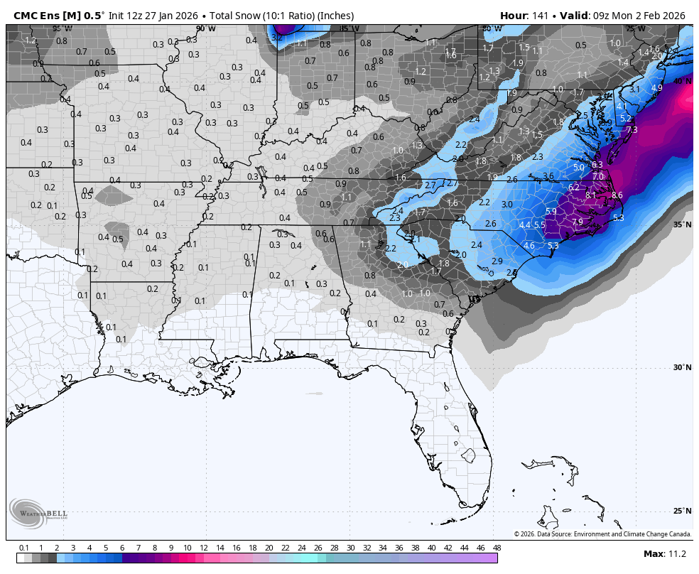
The retrogression up above north of Maine. Yesterday, we saw that ridge extension east of Hudson bay.Watch 540 and 546dm in Canada, notice how they are farther E when the Canadian was going south and bombing but have relaxed so the system has leaked E, need more thumb ridge
View attachment 190085
i'm also thinking about how the aifs "jumps" sometimes... wonder if we're due for oneHonestly could just be sped up a couple of hours vs an actual "change" in location.
I had forgotten about that, on how the AIs can have some sort of interpretation jump vs other models which have that as well as jumps from inputs/initialization or do I have this incorrect.i'm also thinking about how the aifs "jumps" sometimes... wonder if we're due for one
Fascinating to me how just a couple degrees of tilt in a system can create huge changes down the road. For last week, it was the difference between a raging snowstorm and getting an icy mess. This storm is no different, but ironically a little tilt in the back of that trough, just like last week, will be the difference between a few flurries and getting molly-walloped! We should not be surprised the models are having difficulty.Watch 540 and 546dm in Canada, notice how they are farther E when the Canadian was going south and bombing but have relaxed so the system has leaked E, need more thumb ridge
View attachment 190085
Yep it makes it hard to give up on these until 24 hours or so before showtime when its likely more evident that its not going to happenFascinating to me how just a couple degrees of tilt in a system can create huge changes down the road. For last week, it was the difference between a raging snowstorm and getting an icy mess. This storm is no different, but ironically a little tilt in the back of that trough, just like last week, will be the difference between a few flurries and getting molly-walloped! We should not be surprised the models are having difficulty.


This is another model I didn't know anything about. It seems to be trending in the right direction too.6z GenCast (another model from Google that I recently started ingesting) View attachment 190093View attachment 190094View attachment 190095
Very similar to the Canadian Ensemble I just posted. Cool.Slight shift SW actually
View attachment 190096
Coastal looks east, ULL providing all the action...Google finally running...be done in about 15-20 mins
Where can you view the WeatherNext runs?Google coming even drier / farther east. Unreal.
Yep. Probably time to shift focus. This can still be a better than good snow event as it stands. ULL hard to nail down and often gets beefy right up into go-time. We’ll be fineCoastal looks east, ULL providing all the action...
Not over hereYep. Probably time to shift focus. This can still be a better than good snow event as it stands. ULL hard to nail down and often gets beefy right up into go-time. We’ll be fine
It won’t be 39” but I will be shocked if the bulk of yall North Carolina boys don’t see snow with this setupNot over here


