@hr63 op euro is... different. shortwave ticked NW a hair. a little more separation. unsure how it matters downstream
-
Hello, please take a minute to check out our awesome content, contributed by the wonderful members of our community. We hope you'll add your own thoughts and opinions by making a free account!
You are using an out of date browser. It may not display this or other websites correctly.
You should upgrade or use an alternative browser.
You should upgrade or use an alternative browser.
Wintry Machine Learning Mauler 1/30-2/1
- Thread starter SD
- Start date
Euro likes the ULL more this run

BrickTamland
Member
Really looks like it was west, went east, back west, and then east again. Hard to really call that a trend but more back and forth.
packfan98
Moderator
Much better than 6z
iGRXY
Member
This is gonna be a slightly improved euro run I think
 Big improvement IMO
packfan98
Moderator
wow
Member
Euro is walking back.. whew

6z a blip, move on

Looks more back and forth to me than anything
Very good to see6z a blip, move on
View attachment 190063
feel like i live in the stone age with my puny little pivotalwx account when you stormvista guys post the full snowmap an hour before i'm at hour 60
Stormsfury
Member
If that's the case, it shows just how volatile just subtle details are as this juncture. A little noise and chaos theory.Looks more back and forth to me than anything
Big Dog is still on table, alive and kicking
Ha Vista has its pluses and minuses. Graphics are old school which some seem to hate. It has a lot of models that come out fast for the most part…but what I like best about it is that the UI is unbeatablefeel like i live in the stone age with my puny little pivotalwx account when you stormvista guys post the full snowmap an hour before i'm at hour 60
CNCsnwfan1210
Member
Big Dog is still on table, alive and kicking
Plenty of time for positive changes
Sent from my iPhone using Tapatalk
Cary_Snow95
Member
I still note the eastern trend of the base of the trough axis6z a blip, move on
View attachment 190063


packfan98
Moderator
I can't be too mad with this look 102 hours out. Lots of potential.
Footprint remains. Plenty of time to beef up totals and death bands. Also plenty of time to crash and burn. Next
iGRXY
Member
Best guess: the GFS trends worse, the euro trends better, they meet somewhere near the AIFS. Wouldn’t be surprised to see the AIFS go a hair back west as we get closer and we settle on a really good event for most everyone. Those 2-3ft runs were pretty to look at but most reasonable estimate is 4-8” in the western carolinas and probably a swath of 6-12”+ amounts in a couple of bands that no one has a clue where it’ll setup
nice modest capitulation back to the median by the euro. like the coastal precip making it to little washington. lets stack a few more of those
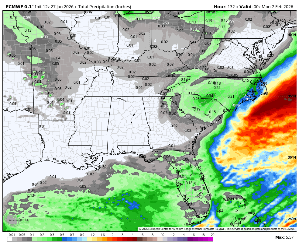
Total QPF on Euro AI

- Joined
- Jan 23, 2021
- Messages
- 4,604
- Reaction score
- 15,203
- Location
- Lebanon Township, Durham County NC
I think this event is primed to overachieve:
Soil temps should be at or below freezing by Saturday
The DGZ starts at approximately the top of the Bank of America building.
Cold surface temps(likely in the teens) during the event.
Soil temps should be at or below freezing by Saturday
The DGZ starts at approximately the top of the Bank of America building.
Cold surface temps(likely in the teens) during the event.
NBAcentel
Member
I’m starting to notice that Piedmont maxima with the upper level low. Charlotte has won these before in the past


- Joined
- Jan 23, 2021
- Messages
- 4,604
- Reaction score
- 15,203
- Location
- Lebanon Township, Durham County NC
2003 vibesI’m starting to notice that Piedmont maxima with the upper level low. Charlotte has won these before in the past View attachment 190076
Edward Nygma
Member
My take is that any modeling solution is possible from the GFS to the ICON / Euro. We've basically seen all modeling suites jump between the various solutions from the neg tilt monster to the light ULL snow and vice versa. AI guidance is going to be slower to adjust but something tells me they are prone to a "snap" adjustment here one way or the other.
Cary_Snow95
Member
Someone mentioned 2018 and this does remind me of that quite a bit. The northern stream amped about 24 hours out and continued all the way up until 0 hour. It became more neutral tilt and qpf amounts literally went from 0.2 to .6-.8 within 2 cycles.
CJ on it..love the high ratio talk. You don’t need much qpf to make it special 
- Joined
- Jan 23, 2021
- Messages
- 4,604
- Reaction score
- 15,203
- Location
- Lebanon Township, Durham County NC
Literally everything we normally have going against us is for us this go around. all we need is moisture.
You and me both. I'm thinking long and hard about biting the bullet and getting the Storm Vista subscription too. The maps aren't nearly as nice but it does have the new AI models which have performed so well.feel like i live in the stone age with my puny little pivotalwx account when you stormvista guys post the full snowmap an hour before i'm at hour 60
BrickTamland
Member
Great Euro run compared to the last UK and Euro run.
snowlover91
Member
To my untrained eye, that looks more like minor fluctuations rather than a trend no?
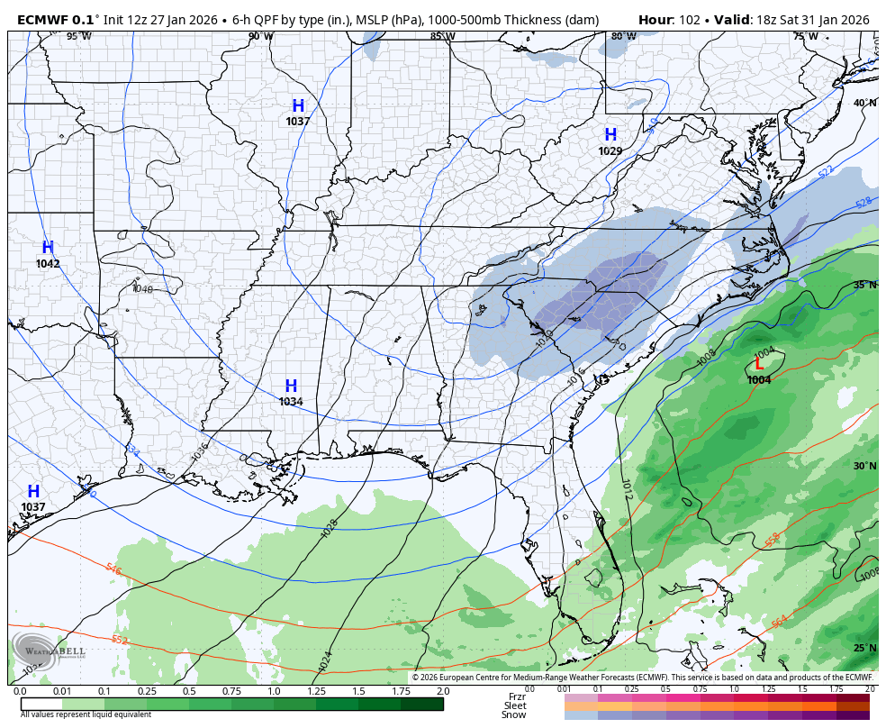
Gradual ticks to the SE with the surface low and 5h features with precip less expansive and confined closer to ENC. If the SE ticks continue then you’ll get an ICON or UK type of solution.

I breathed a loud sigh of relief to see the Euro stop its track to the east. There is still a ways to go but what this run showed eased my concerns this storm will be a Southern slider. There is still a lot of time between now and Sunday and one thing is certain, there will be changes in the storm track and amounts but at least they are showing a storm and potential for a big one if things go right.

Why am I getting January 18 2018 vibes..

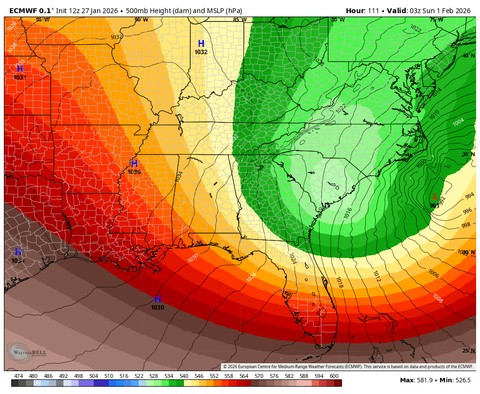
This is one impressive cold air push we are getting. The 540 line is all the way into Central Florida
CNCsnwfan1210
Member
522 line running through central NC, a good bet there is some higher ratio snowfall better than 10:1
Sent from my iPhone using Tapatalk
Mahomeless
Member
- Joined
- Oct 17, 2023
- Messages
- 900
- Reaction score
- 2,158
Honestly could just be sped up a couple of hours vs an actual "change" in location.AIFS is still really consistent with the upper level low, given how hard it is for models to resolve them View attachment 190055