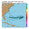
I know that few are paying this much attention right now, but the 18Z GFS actually had a semi-interesting result fwiw, a legit LF of a very weak barely closed sfc low at Cape Canaveral at 192. It is a potentially dangerous track if it were to be strong.
-
Hello, please take a minute to check out our awesome content, contributed by the wonderful members of our community. We hope you'll add your own thoughts and opinions by making a free account!
You are using an out of date browser. It may not display this or other websites correctly.
You should upgrade or use an alternative browser.
You should upgrade or use an alternative browser.
Tropical Karen
- Thread starter GaWx
- Start date
pcbjr
Member
Thank the Good Lord it's not ...I know that few are paying this much attention right now, but the 18Z GFS actually had a semi-interesting result fwiw, a legit LF of a very weak barely closed sfc low at Cape Canaveral at 192. It is a potentially dangerous track if it were to be strong.
Jessy89
Member
For the record, here is a high resolution 18Z GFS sfc wind flow map showing Karen’s tiny sfc low “landfalling” at Cape Canaveral:
View attachment 24031
It might be a depression or 40mph tropical storm
Sent from my iPhone using Tapatalk
pcbjr
Member
No thank you, to be very selfish here ... that through the 5th are my Cedar Key sanity days ... no rain, no wind, nothing but sea gulls, oysters, redfish ... and an adult beverage or 10 ...It might be a depression or 40mph tropical storm
Sent from my iPhone using Tapatalk
The operational models still dissipate Karen and not one single EPS member gets her anywhere close to the US with almost all dissipating as well....
But she sure is trying atm, wouldn't it be something if she took full advantage of the short window of opportunity and blew up, that would throw a monkey wrench into things. Not saying it will happen and channeling my inner @GaWx statistical side, I'd give that about a 5% chance.
But she sure is trying atm, wouldn't it be something if she took full advantage of the short window of opportunity and blew up, that would throw a monkey wrench into things. Not saying it will happen and channeling my inner @GaWx statistical side, I'd give that about a 5% chance.
Not meaning to scare @pcbjr at all but the 6Z GFS is the 2nd in the last 3 that technically per the high resolution run that I have access to has a FL LF of a very weak and tiny closed sfc low meaning there’s still a potentially dangerous path if this were to be stronger than models are showing. Whereas the 18Z had it at Cape Canaveral moving NNW, the 6Z has it just N of WPB moving W.


Last edited:
Ethan80963!
Member
Ethan80963!
Member

INIT 26/1500Z 26.6N 63.3W 40 KT 45 MPH
12H 27/0000Z 27.6N 62.5W 40 KT 45 MPH
24H 27/1200Z 28.1N 61.1W 35 KT 40 MPH
36H 28/0000Z 28.0N 60.4W 35 KT 40 MPH
48H 28/1200Z 27.8N 60.6W 30 KT 35 MPH
72H 29/1200Z 27.3N 63.5W 25 KT 30 MPH...POST-TROP/REMNT LOW
96H 30/1200Z 27.1N 66.5W 25 KT 30 MPH...POST-TROP/REMNT LOW
120H 01/1200Z 27.0N 69.0W 25 KT 30 MPH...POST-TROP/REMNT LOW
Shaggy
Member
If this all plays out as expected then I say this was handled very well by the models way in advance. Most have had some form of very weak remnants moving westward for numerous days and it appears they were correct all along.
GeorgiaGirl
Member
KAREN LOOKS TO BE SOMEWHAT FIRING SOME GOOD DEEP CONVECTION AT THIS TIME. ALSO NOTE LORENZO IS VERY IMPRESSIVE AND THERE IS ANOTHER WAVE COMMING OFF AFRICA THAT SHOULD BE WATCHED
With the pattern we're in, any waves coming off from Africa will probably not be a US threat. The next possible thing we'll need to start keeping an eye on are the CAGs which could cause a gulf system.
Ethan80963!
Member
Henry2326
Member
That's what I've been waiting on.....ridge always softens as it moves closer. Hope its just rain.
That's what I've been waiting on.....ridge always softens as it moves closer. Hope its just rain.
At 168, when the 12Z GFS has the remnant sfc low at Melbourne, FL, (not quite closed in this run but it is clearly there per the high resolution map) the 12Z Euro has the remnant low only 1,000 miles E of the GFS way out only a few hundred miles SW of Bermuda. Can you say "model disagreement"?
Henry2326
Member
Typical....I watch for possible options but only get worried 3 days or so away. They just don't have definitive solutions any further out. Which is sad considering that people can die with only a 3 day window.At 168, when the 12Z GFS has the remnant sfc low at Melbourne, FL, (not quite closed in this run but it is clearly there per the high resolution map) the 12Z Euro has the remnant low only 1,000 miles E of the GFS way out only a few hundred miles SW of Bermuda. Can you say "model disagreement"?
Ethan80963!
Member


