-
Hello, please take a minute to check out our awesome content, contributed by the wonderful members of our community. We hope you'll add your own thoughts and opinions by making a free account!
You are using an out of date browser. It may not display this or other websites correctly.
You should upgrade or use an alternative browser.
You should upgrade or use an alternative browser.
Pattern JUULY 2025 Smokin Heat Thraad
- Thread starter SD
- Start date
Brent
Member


Shaggy
Member
79/79 this morning. Forecast yesterday missed by 3 or so degrees and today is supposed to be 93.......maybe we can miss 3 degrees again today!!
Broken Clouds saving us so far. But only matter of time.
10 am temp 83 GSO
10 am temp 83 GSO
Shaggy
Member
You know it has been a very hot stretch when 90 over 77 and the heat index of 103 doesn't really feel all that bad
Interesting cloud movement on visby today still some kind of convergent axis in the wake of the weak meso low sneaking down toward Sampson county. Wonder if it fires up more today
JHS
Member
Not if it's the feature you mentioned, but widespread storms have formed in 2 separate places already. One from east of Charlotte to south of Greensboro, the other from near Myrtle Beach up to Rockingham.Interesting cloud movement on visby today still some kind of convergent axis in the wake of the weak meso low sneaking down toward Sampson county. Wonder if it fires up more today
There’s a sudden popup heavy thunderstorm that just formed only a couple of miles from me. It’s hard to tell whether or not it will spread out or generate others nearby to give me rain. The other possibility is for it to move toward me although I’m leaning against that right now based on subtle hints and H5 model progs suggesting it might move to the E. Regardless, steering winds are very light and flash flooding is a concern for wherever it lingers.
1:20 PM update: initial cell drifted away but it lead to more developing including at my location. Temp plunged from 92 to 80 within just a few minutes in the rain!
3:30PM update: I received only ~0.05”. Temp rose back some but only to 82 thus far.
1:20 PM update: initial cell drifted away but it lead to more developing including at my location. Temp plunged from 92 to 80 within just a few minutes in the rain!
3:30PM update: I received only ~0.05”. Temp rose back some but only to 82 thus far.
Last edited:
Asheboro an GBoro want make 90 degree club today. T storms got going early
JP152
Member
96/81 at KTPA.. 118 Heat Index.
Got to 95 but now getting our first real storm in a while. About a Quarter inch in ~10min
Shaggy
Member

JHS
Member
Nothing here again today and not expecting anything right through the next few days. We may as well have a 0% pop here. I still would not be shocked at all if that front never comes below I-40 leaving many of us in the heat right through the weekend.
Avalanche
Member
It grazed my house too

ATL officially hit 100 at 4:40pm
Only 94.2 so far
JHS
Member
It's coming into NAM range now and the cooler air is delayed. It's coming in from the NW now and that means the mountains will hold it up. Sat will be another hot one in most of NC and SC.
Actually the 6z Nam is the coldest model out there at hr 18z Saturday. Still think most of NC stays in the 70's Saturday, probably more due to NE winds, clouds. You need the backdoor front to jackpot and stay below 80 for a couple days.It's coming into NAM range now and the cooler air is delayed. It's coming in from the NW now and that means the mountains will hold it up. Sat will be another hot one in most of NC and SC.

JHS
Member
It's time to cut precip chances and issue more heat advisories today in the GSP area. The HRRR is almost completely dry over both Carolinas today, even the mountains. The 6zGFS finally has a clue on precip showing 2-3 inches over a large area now, but with one small area that stays much drier and it's right over me. It just cannot rain around rain around here again, I guess.
I'm not sure how far sout the front will actually get. Thinking that most of NC stays in the 80s through the weekend, except mountains and maybe foothills. Still, it should feel really good compared to the horrible weather of late.
JHS
Member
It's all about how much sun we get. If it's cloudy and rainy much of NC might have a problem reaching 70. If Sat and Sun are sunny days many of us see 85 to even 90 no problem.I'm not sure how far sout the front will actually get. Thinking that most of NC stays in the 80s through the weekend, except mountains and maybe foothills. Still, it should feel really good compared to the horrible weather of late.
Highs either side of 80 with a stiff NE wind did i miss something?
Iceagewhereartthou
Member
GSP officially broke the 90 degree day streak yesterday at 39 straight which is pretty major. During that stretch; since June 21, it reached 100 twice and 95 or greater 17 times, which is also a lot. The current monthly temp is 83.1, which is just one tenth lower than the all time hottest July ever, which was July 93 at 83.2. The hottest month ever was August 07 at an astounding 84.7! But basically saying; this has been one of the 3 hottest months ever at GSP, and now the longest stretch of consecutive 90 degree days ever. And this has happened without drought conditions. This is historic.

Shaggy
Member
Watching all kind of boundaries unzip down here storms popping up everywhere on my second round of storms now and they are very Electric
Shaggy
Member
Also a sub 90 degree day as the clouds and storms formed early and kept us to a high of 88
JHS
Member
Well, the widespread 3-4 inches of rain for tomorrow through Sunday is long gone now just like I know it would be. Some of us will not get a drop with this. We are already 5 degrees over our forecast for today now and I fully expect this to continue. GSP is already talking about heat advisories for tomorrow and Friday too. They will eventually happen and I would not be shocked if we get 2 more shots at 100 at GSP.
Stats
7/18 96/77
7/19 95/75
7/20 95/74
7/21 95/74
7/22 88/75
7/23 88/65
7/24 96/72
7/25 99/72
7/26 103/75
7/27 101/76
7/28 100/75
7/29 94/72
7/30 93/76
7/31 92/75
Pretty brutal 2 weeks minus the 2 day break
7/18 96/77
7/19 95/75
7/20 95/74
7/21 95/74
7/22 88/75
7/23 88/65
7/24 96/72
7/25 99/72
7/26 103/75
7/27 101/76
7/28 100/75
7/29 94/72
7/30 93/76
7/31 92/75
Pretty brutal 2 weeks minus the 2 day break
Downeastnc
Member
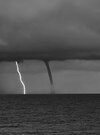
These storms rolling through the coastal plains tonight are downright scary. Continuous rolling thunder for a half hour before they got here then LOTS of CTG lightning throughout. Big nasty bolts either streamers in every direction.
Sitting at 10.26” for the month. May eke out a bit more before midnight.
Sitting at 10.26” for the month. May eke out a bit more before midnight.
Shaggy
Member
In those storms that rolled off your area and along the caoe fear region yesterday morning produced 421 strikes in 15 minutes apparently.These storms rolling through the coastal plains tonight are downright scary. Continuous rolling thunder for a half hour before they got here then LOTS of CTG lightning throughout. Big nasty bolts either streamers in every direction.
Sitting at 10.26” for the month. May eke out a bit more before midnight.
Shaggy
Member
Radar has a look of training over my neck of the woods this morning. Gotna feeling we are about to get a bunch more rain. At 2.8 for the week already
Avalanche
Member
It’s been great sleeping weather.Radar has a look of training over my neck of the woods this morning. Gotna feeling we are about to get a bunch more rain. At 2.8 for the week already
Shaggy
Member
My alarm for work goes off at 5:05am every day. I wouldn't know lol.It’s been great sleeping weather.
Looks like the heavy stuff finally shifted south of us and will get the southern beaches. That's fine I've had plenty of rain for the last 2 days. I'm sure this put me well over 3 inches in 36 hours
Avalanche
Member
Yeah I’m like 5 miles north of you and since I’ve moved down here I have never seen so many frequent afternoon thunderstorms since I lived in Florida.My alarm for work goes off at 5:05am every day. I wouldn't know lol.
Looks like the heavy stuff finally shifted south of us and will get the southern beaches. That's fine I've had plenty of rain for the last 2 days. I'm sure this put me well over 3 inches in 36 hours