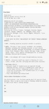
really quite nice today. settling into our first stretch of closer-to-real-summer now
-
Hello, please take a minute to check out our awesome content, contributed by the wonderful members of our community. We hope you'll add your own thoughts and opinions by making a free account!
You are using an out of date browser. It may not display this or other websites correctly.
You should upgrade or use an alternative browser.
You should upgrade or use an alternative browser.
Pattern June’s Drought Dialogues
- Thread starter SD
- Start date
Brent
Member
These upper 40's mornings aren't good for my Tomatoes, but man what a streak of good fortune this entire spring. It's been like October here since March. 3 days into June and the good fortune is continuing.
Well I was wrong haha another 47 cool start to a June morning47 to start June, last nice morning for a while I'm sure
Brent
Member
Like a summer morning here.... 76/72 
We're still not done with the cold fronts though.... Wednesday may struggle to get above the low 70s if we don't clear out
We're still not done with the cold fronts though.... Wednesday may struggle to get above the low 70s if we don't clear out
It got down to 53.6 degrees here at my house which is about a mile southeast of Lake Wheeler in Wake County as the crow flies. This will probably be the last morning like that for a while. This run of below average temperatures has been nice.
Not relevant to the Carolinas in the southeast but I get to punch through this with the 24 foot jayco to Omaha

Sent from my iPhone using Tapatalk

Sent from my iPhone using Tapatalk
Brent
Member
BHS1975
Member
Looks like one more cool shot and then we bake.
Without having any idea that this would occur, I got a heavy shower suddenly at ~1:45AM (6/4) but it ended after no more than 5 minutes. I looked on radar and saw that it came from a rather unusual direction, from offshore moving WNW.
Edit: That shower here late that night was just a quick, isolated rain. But late that morning (6/4), it had been much more widespread in SE GA.
All of that rain along with some light rain the subsequent days added to ~0.75”
Edit: That shower here late that night was just a quick, isolated rain. But late that morning (6/4), it had been much more widespread in SE GA.
All of that rain along with some light rain the subsequent days added to ~0.75”
Last edited:
Yea we all know its gonna come, just like they know for sure the cold always show up in upper Michigan during the winter. Heat is a gurantee in the south.Looks like one more cool shot and then we bake.
Good news is the days start shortening here in just about 17 more days. Goal in June is to avoid 90 degree days. That's a win if you can do it. Come July /August, we are all just out of luck and have to suck it up for 2 months lol.
It got down to 58.2 degrees this morning for a low at my house. I hope I am wrong but I believe this may be the last low temperature in the fifties that I see for several months to come.
Brent
Member
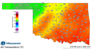
You guys have it all in Oklahoma. I watch the Arms family on YouTube, not sure of the locale in the state but a ton of rain for sure and I know it’s been warm for y’all. I think our drought is done for now but always subject to change!It's 3pm in June View attachment 173010
Minor flooding on this 2-4 inch daily rain event thats popped up out of nowhere. 69 degrees at high noon. Keep Betting the streak
Should get a handful of storms to roll of the escarpment mid-afternoon today. Environment looks perfectly acceptable for some nice storms in foothills NC/SC and central VA
JHS
Member
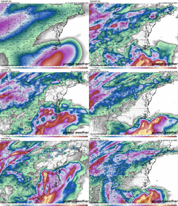
The Euro and the GFS say we bake bigtime by around June 20. Temps from 100-105 for many of us and lows from 80-85 for a good many of us.
Is this before or after the hurricaneThe Euro and the GFS say we bake bigtime by around June 20. Temps from 100-105 for many of us and lows from 80-85 for a good many of us.
89.8 dews in he 70s most of the day. Fun in the summer has arrived
CHA picked up its 1st official 90 of the year today. Latest into the season for a 1st 90 since 2013.
Brent
Member
Saw a lot of flooding this morning
When drought
When drought
We’re having a ton of what I would call heat lightning on the southern Caburrus northern Union county line. Glowing orange. I’ll try and get a pic if I can!
JHS
Member
I don't think any hurricane will verify, but the heat might since both the GFS and Euro had it. However, it looks like the 18z GFS backed down some. Still hot, but about 10-12 degrees cooler than the 12z run.Is this before or after the hurricane
88/66 hike this morning was humid as all get out
The dewpoint is right at least for some severe weather later this afternoon. I was planting part of my late vegetable garden and taking more breaks than normal due to the sanua like conditions. It could get interesting later today and this evening if we get some storms that roll through.
BrickTamland
Member
Feels like a wet blanket on you working outside on days like this.The dewpoint is right at least for some severe weather later this afternoon. I was planting part of my late vegetable garden and taking more breaks than normal due to the sanua like conditions. It could get interesting later today and this evening if we get some storms that roll through.
Downeastnc
Member
Feels like a wet blanket on you working outside on days like this.
We had a nice big ole nighttime thunderstorm around 430 this morning with lots of big house rattling thunder.....took the dog for her morning walk at 730 am and it was a short one cause its a tad bit muggy out there already.
Brent
Member
Today was the first time in 3 days we didn't have predawn thunderstorms
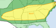
But there is a big severe risk later today especially to my SW. Possible derecho towards Dallas tonight
But there is a big severe risk later today especially to my SW. Possible derecho towards Dallas tonight
What's a thunderstorm
What's a thunderstorm
Brent
Member
What's a thunderstorm
You can have ours. If I see one more post about how it's a conspiracy to have thunderstorms in tornado alley im gonna snap
Apparently we never have any days with normal weather anymore
Looking at the Euro and GFS on Pivotal Weather, there looks to be no abnormally hot weather at least through the end of the model runs. Most of the scorching heat seems to be confined to the middle section of the United States. By the end of next week, highs look to be running a little below normal in North Carolina. Any break you can get from the heat during the summer months is a good thing.
snowc
Member
Just wait till July... Severe heat and DPs in 80s...Looking at the Euro and GFS on Pivotal Weather, there looks to be no abnormally hot weather at least through the end of the model runs. Most of the scorching heat seems to be confined to the middle section of the United States. By the end of next week, highs look to be running a little below normal in North Carolina. Any break you can get from the heat during the summer months is a good thing.
I've lost track of how many consecutive days my back yard has had at least a pop up shower. Seriously its in the double digits. 180 degrees opposite of last May into June.
packfan98
Moderator
Yeah, I’m tired of mowing every 5-6 days.I've lost track of how many consecutive days my back yard has had at least a pop up shower. Seriously its in the double digits. 180 degrees opposite of last May into June.
BrickTamland
Member
Another Weather Alert day.
BrickTamland
Member
It's actually been dry enough for you to mow?Yeah, I’m tired of mowing every 5-6 days.


