• Hello, please take a minute to check out our awesome content, contributed by the wonderful members of our community. We hope you'll add your own thoughts and opinions by making a free account!

Pattern July Fry and Dry

Most CAMs seem to like the I-85 corridor between CLT/GSO/RDU for the most rainfall today, some large pockets of 2-3" with higher localized. Latest HREF likes Chatham and Orange again as well. qpf_024h_pmm.ma.f02400 (1).png
 
A band of heavy thunderstorms has popped up in this area early this afternoon along the seabreeze. Coming down pretty hard now.

Edit: That storm ended up being pretty wet. We also got a small amount late in the afternoon from other showers. Total for the day (7/9/25): ~0.75ā€.
 
Last edited:
SEVERE THUNDERSTORM WATCH #497 HAS BEEN ISSUED UNTIL 10PM TONIGHT.
SEVERE THUNDERSTORM WATCH #500 IS GOING TO BE ISSUED.
ww0500_radar.gif


ww0497_radar.gif

Refresh page if graphic doesn't showmcd1614.png
 
Last edited:
PAIN (apologies, again to @tractor girl )
NWS Raleigh AND WRAL were down due to a vehicle hitting powerline. Back online before 4:30p. AKQ is doing SVRs and FFWs.
UPDATE: Power back on now.
1752085183332.png
 

Attachments

  • 1752085176681.png
    1752085176681.png
    459.8 KB · Views: 2
Last edited:
I'm on the lookout for any signs of relief; the long range GFS has been showing this front after mid-month for awhile now. Per climo; it doesn't look to make it past the Apps with the refreshing air, but it does cause more of a trough in the East an back off on the heights for us. Could be a nice little change if it happens.

1752088621860.gif
 
We’re drying out bad. Need a super soaker
1 more chance tomorrow and if that misses, we have to wait 7-10 days for another chance. These storms just do not like the I-85 corridor from Atlanta to north of Charlotte, so our chance tomorrow does not look good.
 
Cut the grass today and boy was it crunchy even down in the floodplain. Ground's cracking. Hoping this little boundary parked over Spartanburg Co can ignite
I do not see it happening today or tomorrow for that matter. Most of the rain will be from I-77 east or along I-20 south both days. We are probably 7-10 days away or longer from good rain in the GSP metro. Our biggest story will be the heat continuing and getting more intense.
 
Been cooking a little outside for about 20ish minutes or so, but the house hilariously somehow whiffed on everything closer to the lunch hour again.

At least based on Dad.
 
@SD your goose is now cooked
WUUS52 KRAH 092303
SVRRAH
NCC037-085-093-105-125-151-100000-
/O.NEW.KRAH.SV.W.0204.250709T2303Z-250710T0000Z/

BULLETIN - IMMEDIATE BROADCAST REQUESTED
Severe Thunderstorm Warning
National Weather Service Raleigh NC
703 PM EDT Wed Jul 9 2025

The National Weather Service in Raleigh has issued a

* Severe Thunderstorm Warning for...
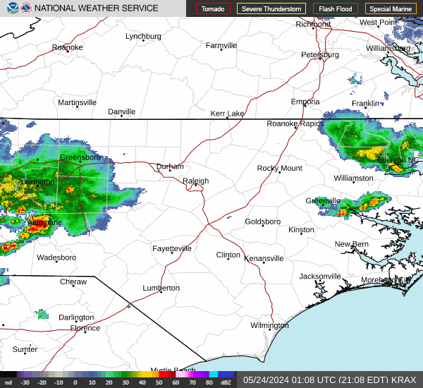
Moore County in central North Carolina...
Southwestern Harnett County in central North Carolina...
Southeastern Randolph County in central North Carolina...
Lee County in central North Carolina...
Northwestern Hoke County in central North Carolina...
Chatham County in central North Carolina...

* Until 800 PM EDT.

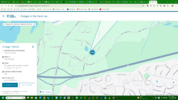
* At 703 PM EDT, severe thunderstorms were located along a line
extending from 10 miles east of Biscoe to near Pinehurst, moving
northeast at 40 mph.

HAZARD...60 mph wind gusts.

SOURCE...Radar indicated.

IMPACT...Expect damage to roofs, siding, and trees.

* Locations impacted include...
Sanford, Southern Pines, Pittsboro, Carthage, Pinehurst, Aberdeen,
Goldston, Whispering Pines, Pinebluff, and Broadway.

PRECAUTIONARY/PREPAREDNESS ACTIONS...

Straight line winds can blow down trees, power lines, and damage
mobile homes and other buildings. Seek shelter in a sturdy structure
until the storm has passed. Stay away from windows as flying debris
generated by damaging winds can be deadly.

&&

LAT...LON 3506 7948 3515 7953 3531 7956 3542 7964
3551 7977 3552 7980 3586 7910 3586 7905
3553 7901 3532 7903 3502 7943
TIME...MOT...LOC 2303Z 226DEG 35KT 3538 7960 3516 7956

HAIL THREAT...RADAR INDICATED
MAX HAIL SIZE...<.75 IN
WIND THREAT...RADAR INDICATED
MAX WIND GUST...60 MPH

$$

26
 
Crazy OFB collision about to go down around Greenville SC, let's see if we can get this line from GSO to Anderson SC
 
There is some heavy rain with this impressive line of thunderstorms that is about to roll through Wake and surrounding counties. I think there are going to be a lot of flash flood warnings in urban areas coming up soon.
 
Crazy OFB collision about to go down around Greenville SC, let's see if we can get this line from GSO to Anderson SC
Those boundaries did touch off storms, but that solid line is probably not coming far into SC. If these boundaries had arrived 2-3 hours earlier, it's probably a different story. The Raleigh area is about to get nailed and maybe Charlotte too with that line.
 
Durham PD said to avoid the following areas due to flooding:
-Anderson Rd. / Chapel Hill Rd.
-Garrett Rd. / Durham Chapel Hill Blvd.
-4200 Block of University Dr. (Between Martin Luther King Jr. Blvd. and Shannon Rd.)
-N. Duke St. / W. Morgan St.
-Hunt St./Foster St.
 
Back
Top